<< Text Pages >> Tel Shiloh - Ancient Village or Settlement in Israel
Submitted by bat400 on Saturday, 09 November 2013 Page Views: 2161
Multi-periodSite Name: Tel ShilohCountry: Israel
NOTE: This site is 0.898 km away from the location you searched for.
Type: Ancient Village or Settlement
Latitude: 32.057000N Longitude: 35.289000E
Condition:
| 5 | Perfect |
| 4 | Almost Perfect |
| 3 | Reasonable but with some damage |
| 2 | Ruined but still recognisable as an ancient site |
| 1 | Pretty much destroyed, possibly visible as crop marks |
| 0 | No data. |
| -1 | Completely destroyed |
| 5 | Superb |
| 4 | Good |
| 3 | Ordinary |
| 2 | Not Good |
| 1 | Awful |
| 0 | No data. |
| 5 | Can be driven to, probably with disabled access |
| 4 | Short walk on a footpath |
| 3 | Requiring a bit more of a walk |
| 2 | A long walk |
| 1 | In the middle of nowhere, a nightmare to find |
| 0 | No data. |
| 5 | co-ordinates taken by GPS or official recorded co-ordinates |
| 4 | co-ordinates scaled from a detailed map |
| 3 | co-ordinates scaled from a bad map |
| 2 | co-ordinates of the nearest village |
| 1 | co-ordinates of the nearest town |
| 0 | no data |
Be the first person to rate this site - see the 'Contribute!' box in the right hand menu.
Internal Links:
External Links:
Ancient Settlement in the West Bank.
Archaeological excavations have shown occupation as early as 19th-18th centuries BC. (Middle Bronze Age II A.) A large mound from the Caananite and Israelite eras, until the 8th century BC. During the following 12 centuries Shiloh is solely noted as a station on sojourners' routes. Archeological excavations have revealed remains from the Roman and Persian as well as early and late Moslem periods.
Excavations have taken place periodically since 1922. An extensive excavation (1981-84) showed eight periods of occupation, from Middle Bronze II to Byzantine.
Finds of pottery and animal sacrefice points to a sacred status of Shiloh during the Canaanite period, a status adopted by the Israelites. But the top of the tel, where a tabernacle would have been placed, is now exposed bedrock, offering no clues concerning Israelite worship.
By C14 dating, the site was abandoned around 1050 BCE, and then sparsely repopulated during the Iron II period. More substantive villages emerged in Roman and Byzantine periods, with finds of a mosaic floor of a large Byzantine church (~80 and 420 AD.)
Source: .wikipedia.org
Note: Recent archaeological findings in Samaria shed light on the incomplete story of the destruction of Shiloh, the ancient capital of Israel.
You may be viewing yesterday's version of this page. To see the most up to date information please register for a free account.
Do not use the above information on other web sites or publications without permission of the contributor.
Nearby Images from Flickr
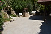
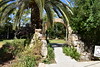
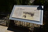
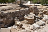


The above images may not be of the site on this page, but were taken nearby. They are loaded from Flickr so please click on them for image credits.
Click here to see more info for this site
Nearby sites
Click here to view sites on an interactive map of the areaKey: Red: member's photo, Blue: 3rd party photo, Yellow: other image, Green: no photo - please go there and take one, Grey: site destroyed
Download sites to:
KML (Google Earth)
GPX (GPS waypoints)
CSV (Garmin/Navman)
CSV (Excel)
To unlock full downloads you need to sign up as a Contributory Member. Otherwise downloads are limited to 50 sites.
Turn off the page maps and other distractions
Nearby sites listing. In the following links * = Image available
7.3km WSW 243° The Gilgal associated with Elijah and Elisha Stone Circle
17.3km N 356° Jacob's Well (Bir Ya'Qub)* Holy Well or Sacred Spring
19.9km N 357° Mount 'Ebal Ancient Temple
24.0km ENE 61° Argaman-Gilgal sanctuary Ancient Temple
25.6km SE 139° The Gilgal associated peacefully with Joshua Stone Circle
26.3km E 80° Damiyah dolmen field* Burial Chamber or Dolmen
26.8km SSE 149° Jericho* Ancient Village or Settlement
27.9km S 189° Shuafat road Chalcolithic period site* Ancient Village or Settlement
28.8km W 279° Ancient Farm near Rosh Ha'ayin * Ancient Village or Settlement
29.7km WNW 282° Qesem Cave* Cave or Rock Shelter
30.7km S 189° 2000 year old stone fragment in Jerusalem* Marker Stone
31.5km S 189° Temple Mount* Ancient Temple
31.7km SSW 201° Tel Motza* Ancient Village or Settlement
31.9km S 189° City of David* Ancient Village or Settlement
32.0km SSW 205° Motza Neolithic City* Ancient Village or Settlement
32.0km S 189° Hezekiah's Tunnel* Ancient Mine, Quarry or other Industry
32.8km WSW 258° Mosaic and Stone structure near Shoham Ancient Village or Settlement
33.5km WNW 289° The Gilgal associated violently with Joshua Stone Circle
34.2km W 279° Antipatris* Ancient Village or Settlement
34.8km SSW 191° Talpiot Tomb Rock Cut Tomb
37.2km SW 229° Emmaus Ancient Village or Settlement
38.0km WSW 253° Lod Mosaic Ancient Palace
38.3km SSW 192° Rachel's Tomb Ancient Temple
38.6km SSE 155° Qumran* Ancient Village or Settlement
38.8km NNE 16° Gadara* Ancient Village or Settlement
View more nearby sites and additional images


 We would like to know more about this location. Please feel free to add a brief description and any relevant information in your own language.
 Wir möchten mehr über diese Stätte erfahren. Bitte zögern Sie nicht, eine kurze Beschreibung und relevante Informationen in Deutsch hinzuzufügen.
 Nous aimerions en savoir encore un peu sur les lieux. S'il vous plaît n'hesitez pas à ajouter une courte description et tous les renseignements pertinents dans votre propre langue.
 Quisieramos informarnos un poco más de las lugares. No dude en añadir una breve descripción y otros datos relevantes en su propio idioma.