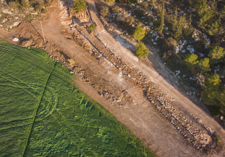
<< Other Photo Pages >> 2,000-year-old ‘Emperor’s Road’ near Beit Shemesh - Ancient Trackway in Israel
Submitted by motist on Tuesday, 07 March 2017 Page Views: 1091
Roman, Greek and ClassicalSite Name: 2,000-year-old ‘Emperor’s Road’ near Beit ShemeshCountry: Israel
NOTE: This site is 5.066 km away from the location you searched for.
Type: Ancient Trackway
Nearest Town: Beit Shemesh
Latitude: 31.687299N Longitude: 35.000991E
Condition:
| 5 | Perfect |
| 4 | Almost Perfect |
| 3 | Reasonable but with some damage |
| 2 | Ruined but still recognisable as an ancient site |
| 1 | Pretty much destroyed, possibly visible as crop marks |
| 0 | No data. |
| -1 | Completely destroyed |
| 5 | Superb |
| 4 | Good |
| 3 | Ordinary |
| 2 | Not Good |
| 1 | Awful |
| 0 | No data. |
| 5 | Can be driven to, probably with disabled access |
| 4 | Short walk on a footpath |
| 3 | Requiring a bit more of a walk |
| 2 | A long walk |
| 1 | In the middle of nowhere, a nightmare to find |
| 0 | No data. |
| 5 | co-ordinates taken by GPS or official recorded co-ordinates |
| 4 | co-ordinates scaled from a detailed map |
| 3 | co-ordinates scaled from a bad map |
| 2 | co-ordinates of the nearest village |
| 1 | co-ordinates of the nearest town |
| 0 | no data |
Internal Links:
External Links:

Archeologists discover 2,000-year-old ‘Emperor’s Road’ near Beit Shemesh
wide and well-preserved 2,000-year-old road dating to the Roman period was unearthed last month during archeological excavations carried out by the Israel Antiquities Authority and students near Beit Shemesh.
The dig, located just off of Highway 375, was conducted prior to laying a water pipeline to Jerusalem at the initiative of the Beit Shemesh water corporation Mei Shemesh.
On Tuesday, Irina Zilberbod, director of the excavation on behalf of the IAA, said the road was up to six meters wide, and stretched for approximately 1.5 kilometers.
“The road was apparently built to link the Roman settlement that existed in the vicinity of Beit Natif with the main highway known as the ‘Emperor’s Road,’” said Zilberbod. “That road was in fact a main artery that connected the large settlements of Eleutheropolis (Beit Guvrin) and Jerusalem.”
According to Zilberbod, construction of the road is believed to have taken place at the time of Emperor Hadrian’s visit to the country, circa 130 CE, or slightly thereafter, during the suppression of the Bar Kochba revolt in 132-135 CE.
“The presence of a milestone [a stone marking distances] bearing the name of the emperor Hadrian, which was discovered in the past close to the road, reinforces this hypothesis,” she said.
Ancient coins were also discovered between the pavement stones, including one from the second year of the Great Revolt in 67 CE; one from the Umayyad period; one from the prefect of Judea, Pontius Pilate, dating to 29 CE; and a coin of Agrippa I from 41 CE, that was minted in Jerusalem.
“Up until 2,000 years ago, most of the roads in the country were actually improvised trails,” said Zilberbod.
“However, during the Roman period, as a result of military and other campaigns, the national and international road network started to be developed in an unprecedented manner. The Roman government was well aware of the importance of the roads for the proper running of the empire.”
From the main roads, such as the Emperor’s Road, there were secondary routes that led to the settlements where all of the agricultural products were grown, she added.
“The grain, oil and wine, which constituted the main dietary basis at the time, were transported along the secondary routes from the surrounding villages, and then by way of the main roads to the large markets in Israel, and even abroad,” explained Zilberbod.
Amit Shadman, the Authority’s district archeologist for Judea, added that the ancient road passed close to the Israel National Trail.
“We believe that it will spark interest among hikers,” said Shadman, noting that the IAA and Mei Shemesh Corporation have agreed that the road will be conserved for the public’s benefit.
You may be viewing yesterday's version of this page. To see the most up to date information please register for a free account.


Do not use the above information on other web sites or publications without permission of the contributor.
Nearby Images from Flickr


The above images may not be of the site on this page, but were taken nearby. They are loaded from Flickr so please click on them for image credits.
Click here to see more info for this site
Nearby sites
Click here to view sites on an interactive map of the areaKey: Red: member's photo, Blue: 3rd party photo, Yellow: other image, Green: no photo - please go there and take one, Grey: site destroyed
Download sites to:
KML (Google Earth)
GPX (GPS waypoints)
CSV (Garmin/Navman)
CSV (Excel)
To unlock full downloads you need to sign up as a Contributory Member. Otherwise downloads are limited to 50 sites.
Turn off the page maps and other distractions
Nearby sites listing. In the following links * = Image available
1.2km NW 320° Ramat Beit Shemesh ritual baths* Ancient Village or Settlement
4.2km WNW 284° Khirbet Qeiyafa* Ancient Village or Settlement
5.0km SSW 212° Khirbat Ethri* Ancient Village or Settlement
6.3km WNW 283° Tel Azeqa Ancient Village or Settlement
6.3km N 355° Tel Beth-Shemesh* Artificial Mound
6.5km SSW 207° Tel Burgin* Ancient Village or Settlement
10.0km SW 233° Tel Goded Ancient Village or Settlement
13.6km SW 226° Bet Guvrin-Maresha National Park* Ancient Village or Settlement
13.7km WSW 242° Tel Burna* Ancient Village or Settlement
13.7km WSW 242° Tel Burna* Ancient Village or Settlement
14.6km W 276° Tel Gath Ancient Village or Settlement
16.8km N 357° Emmaus Ancient Village or Settlement
17.3km NW 305° Tel 'Ekron Ancient Village or Settlement
18.3km NE 48° Motza Neolithic City* Ancient Village or Settlement
18.8km SSW 205° Amatzia* Ancient Mine, Quarry or other Industry
19.4km E 79° Rachel's Tomb Ancient Temple
19.6km NE 54° Tel Motza* Ancient Village or Settlement
19.8km SW 227° Tel Lachish* Artificial Mound
20.2km WSW 238° Ziklag* Ancient Village or Settlement
20.6km NNW 338° Tel Gezer* Ancient Village or Settlement
20.9km SSE 150° Cave of the Patriarchs Rock Cut Tomb
21.6km ENE 71° Talpiot Tomb Rock Cut Tomb
22.9km E 96° Herodion* Ancient Palace
24.1km ENE 67° Hezekiah's Tunnel* Ancient Mine, Quarry or other Industry
24.2km ENE 66° City of David* Ancient Village or Settlement
View more nearby sites and additional images


 We would like to know more about this location. Please feel free to add a brief description and any relevant information in your own language.
 Wir möchten mehr über diese Stätte erfahren. Bitte zögern Sie nicht, eine kurze Beschreibung und relevante Informationen in Deutsch hinzuzufügen.
 Nous aimerions en savoir encore un peu sur les lieux. S'il vous plaît n'hesitez pas à ajouter une courte description et tous les renseignements pertinents dans votre propre langue.
 Quisieramos informarnos un poco más de las lugares. No dude en añadir una breve descripción y otros datos relevantes en su propio idioma.