

<< Our Photo Pages >> Har Rakhama - Ancient Village or Settlement in Israel
Submitted by motist on Friday, 23 March 2007 Page Views: 4390
Multi-periodSite Name: Har RakhamaCountry: Israel Type: Ancient Village or Settlement
Nearest Town: Yeruham
Latitude: 30.967708N Longitude: 34.867866E
Condition:
| 5 | Perfect |
| 4 | Almost Perfect |
| 3 | Reasonable but with some damage |
| 2 | Ruined but still recognisable as an ancient site |
| 1 | Pretty much destroyed, possibly visible as crop marks |
| 0 | No data. |
| -1 | Completely destroyed |
| 5 | Superb |
| 4 | Good |
| 3 | Ordinary |
| 2 | Not Good |
| 1 | Awful |
| 0 | No data. |
| 5 | Can be driven to, probably with disabled access |
| 4 | Short walk on a footpath |
| 3 | Requiring a bit more of a walk |
| 2 | A long walk |
| 1 | In the middle of nowhere, a nightmare to find |
| 0 | No data. |
| 5 | co-ordinates taken by GPS or official recorded co-ordinates |
| 4 | co-ordinates scaled from a detailed map |
| 3 | co-ordinates scaled from a bad map |
| 2 | co-ordinates of the nearest village |
| 1 | co-ordinates of the nearest town |
| 0 | no data |
Internal Links:
External Links:
")
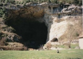
Har (Mt) Rakhama, N' Negev desert, Israel
Situated in central N' Negev desert , 4km SW' to Yeruham.
Tumuli field and cult installations, on the N' of the Mountain habitation site with stone structures, cubes and ingraved mortars, in the walls incorporated Masseboth.
Dated To Middle Bronze A era (2300 - 1900 BCE).
This winter (2006/07) is blessed with a lot of rain, northern Negev desert is blooming.
You may be viewing yesterday's version of this page. To see the most up to date information please register for a free account.
")
")
")
")
")
")
")
")
")
")
")
")
")
")
")
")
")
")
")
")
")
")
")
")
")
These are just the first 25 photos of Har Rakhama. If you log in with a free user account you will be able to see our entire collection.
Do not use the above information on other web sites or publications without permission of the contributor.
Click here to see more info for this site
Nearby sites
Click here to view sites on an interactive map of the areaKey: Red: member's photo, Blue: 3rd party photo, Yellow: other image, Green: no photo - please go there and take one, Grey: site destroyed
Download sites to:
KML (Google Earth)
GPX (GPS waypoints)
CSV (Garmin/Navman)
CSV (Excel)
To unlock full downloads you need to sign up as a Contributory Member. Otherwise downloads are limited to 50 sites.
Turn off the page maps and other distractions
Nearby sites listing. In the following links * = Image available
10.3km WNW 293° Ramat Negev stone wine press* Ancient Mine, Quarry or other Industry
12.1km SW 218° The Lost City* Ancient Village or Settlement
19.8km ENE 71° Mamshit* Ancient Village or Settlement
21.2km SW 218° Har Mihya* Rock Art
21.3km SSW 205° Tel 'Avdat* Ancient Village or Settlement
24.6km WSW 247° Shivta National Park* Ancient Village or Settlement
24.9km NW 305° Haluza Ancient Village or Settlement
26.1km ESE 105° Ma'ale-Akrabbim* Ancient Trackway
30.3km NNW 343° Bir Al Safadi* Ancient Village or Settlement
30.9km N 355° Tel Be'er Shev'a* Ancient Village or Settlement
35.2km NNW 348° Beer Sheva north* Ancient Village or Settlement
35.5km SW 232° Be'er Resisim* Ancient Village or Settlement
37.9km N 5° Shoket Junction* Ancient Village or Settlement
39.1km S 171° Ramat Saharonim* Ancient Temple
39.2km SW 218° Wadi 'Akrav Petroglyphs* Rock Art
40.1km ESE 116° Ein Hatseva fortress* Hillfort
40.5km SE 142° Wadi Marzeba Crenellation Line* Ancient Temple
40.6km S 182° Ramon crater open air sanctuary* Ancient Temple
41.0km S 170° Ein Saharonim* Stone Fort or Dun
41.8km S 174° Wadi Gvanim Ancient Bedouin cemetery* Barrow Cemetery
41.9km S 175° Wadi Gvanim Tumulus and Matsebah* Round Barrow(s)
42.4km NE 35° tel 'Arad* Ancient Village or Settlement
42.7km WSW 256° Tel Nitzana* Ancient Village or Settlement
45.1km SSW 207° Wadi Kabir Matseboth* Ancient Temple
45.4km SSW 206° Wadi Kabir cistern* Ancient Mine, Quarry or other Industry
View more nearby sites and additional images


 We would like to know more about this location. Please feel free to add a brief description and any relevant information in your own language.
 Wir möchten mehr über diese Stätte erfahren. Bitte zögern Sie nicht, eine kurze Beschreibung und relevante Informationen in Deutsch hinzuzufügen.
 Nous aimerions en savoir encore un peu sur les lieux. S'il vous plaît n'hesitez pas à ajouter une courte description et tous les renseignements pertinents dans votre propre langue.
 Quisieramos informarnos un poco más de las lugares. No dude en añadir una breve descripción y otros datos relevantes en su propio idioma.