<< Text Pages >> Nyero Rockpaintings - Rock Art in Uganda
Submitted by KaiHofmann on Thursday, 29 January 2015 Page Views: 1762
Rock ArtSite Name: Nyero RockpaintingsCountry: Uganda
NOTE: This site is 103.386 km away from the location you searched for.
Type: Rock Art
Nearest Town: Kumi
Latitude: 1.476554N Longitude: 33.847328E
Condition:
| 5 | Perfect |
| 4 | Almost Perfect |
| 3 | Reasonable but with some damage |
| 2 | Ruined but still recognisable as an ancient site |
| 1 | Pretty much destroyed, possibly visible as crop marks |
| 0 | No data. |
| -1 | Completely destroyed |
| 5 | Superb |
| 4 | Good |
| 3 | Ordinary |
| 2 | Not Good |
| 1 | Awful |
| 0 | No data. |
| 5 | Can be driven to, probably with disabled access |
| 4 | Short walk on a footpath |
| 3 | Requiring a bit more of a walk |
| 2 | A long walk |
| 1 | In the middle of nowhere, a nightmare to find |
| 0 | No data. |
| 5 | co-ordinates taken by GPS or official recorded co-ordinates |
| 4 | co-ordinates scaled from a detailed map |
| 3 | co-ordinates scaled from a bad map |
| 2 | co-ordinates of the nearest village |
| 1 | co-ordinates of the nearest town |
| 0 | no data |
Be the first person to rate this site - see the 'Contribute!' box in the right hand menu.
Internal Links:
External Links:
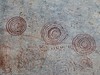
Prehistoric geometric rock paintings spread over six rock shelters. The site is one of the most important rock art in Uganda. It lies 8km west of Kumi town.
You may be viewing yesterday's version of this page. To see the most up to date information please register for a free account.
Do not use the above information on other web sites or publications without permission of the contributor.
Nearby Images from Flickr

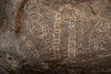
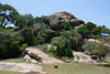
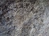
The above images may not be of the site on this page, but were taken nearby. They are loaded from Flickr so please click on them for image credits.
Click here to see more info for this site
Nearby sites
Click here to view sites on an interactive map of the areaKey: Red: member's photo, Blue: 3rd party photo, Yellow: other image, Green: no photo - please go there and take one, Grey: site destroyed
Download sites to:
KML (Google Earth)
GPX (GPS waypoints)
CSV (Garmin/Navman)
CSV (Excel)
To unlock full downloads you need to sign up as a Contributory Member. Otherwise downloads are limited to 50 sites.
Turn off the page maps and other distractions
Nearby sites listing. In the following links * = Image available
41.4km SE 144° Kakoro Rock art Rock Art
126.0km ESE 119° Orchard Cave, Kenya* Cave or Rock Shelter
215.8km S 176° Ukula Rock Paintings Rock Art
258.2km ENE 76° Namoratunga Rock Engravings Rock Art
273.4km ENE 68° Lokori Stone Pillars Standing Stone (Menhir)
293.8km ENE 57° Lothagam Pillar site Standing Stones
306.6km NE 45° Kalokol stone pillars* Standing Stones
318.1km SE 128° Hyrax Hill Ancient Village or Settlement
427.9km ESE 109° Lewa Rock Gongs Rock Art
427.9km W 266° Matupi Cave Cave or Rock Shelter
478.1km SSE 167° Gong Rock* Rock Art
724.1km NE 42° Tutu Fela* Sculptured Stone
879.3km SSE 166° Dodoma Stones* Natural Stone / Erratic / Other Natural Feature
936.5km NE 34° Tiya Stelae Standing Stones
1056.1km S 169° Isimila* Ancient Village or Settlement
1211.3km NNW 334° Dar Kabira settlement* Ancient Village or Settlement
1211.5km NNW 334° Dar Kabira Paintings* Rock Art
1221.1km NNW 335° Tareen basin and cup marks* Carving
1224.3km NNW 335° Warina ancient settlement* Ancient Village or Settlement
1255.7km NNE 17° Gorgora Rock Shelter* Cave or Rock Shelter
1329.1km SSW 192° Mwela rock paintings Rock Art
1451.1km NE 51° Laas Gaal* Cave or Rock Shelter
1505.5km NNE 21° Aksum* Ancient Village or Settlement
1533.2km NNE 21° Yeha* Ancient Village or Settlement
1578.1km N 355° Sudan National Museum Museum
View more nearby sites and additional images


 We would like to know more about this location. Please feel free to add a brief description and any relevant information in your own language.
 Wir möchten mehr über diese Stätte erfahren. Bitte zögern Sie nicht, eine kurze Beschreibung und relevante Informationen in Deutsch hinzuzufügen.
 Nous aimerions en savoir encore un peu sur les lieux. S'il vous plaît n'hesitez pas à ajouter une courte description et tous les renseignements pertinents dans votre propre langue.
 Quisieramos informarnos un poco más de las lugares. No dude en añadir una breve descripción y otros datos relevantes en su propio idioma.