

<< Our Photo Pages >> Great Zimbabwe - Ancient Village or Settlement in Zimbabwe
Submitted by ladrin on Thursday, 19 November 2015 Page Views: 4545
Multi-periodSite Name: Great ZimbabweCountry: Zimbabwe
NOTE: This site is 49.03 km away from the location you searched for.
Type: Ancient Village or Settlement
Nearest Town: Masvingo
Latitude: 20.272805S Longitude: 30.934342E
Condition:
| 5 | Perfect |
| 4 | Almost Perfect |
| 3 | Reasonable but with some damage |
| 2 | Ruined but still recognisable as an ancient site |
| 1 | Pretty much destroyed, possibly visible as crop marks |
| 0 | No data. |
| -1 | Completely destroyed |
| 5 | Superb |
| 4 | Good |
| 3 | Ordinary |
| 2 | Not Good |
| 1 | Awful |
| 0 | No data. |
| 5 | Can be driven to, probably with disabled access |
| 4 | Short walk on a footpath |
| 3 | Requiring a bit more of a walk |
| 2 | A long walk |
| 1 | In the middle of nowhere, a nightmare to find |
| 0 | No data. |
| 5 | co-ordinates taken by GPS or official recorded co-ordinates |
| 4 | co-ordinates scaled from a detailed map |
| 3 | co-ordinates scaled from a bad map |
| 2 | co-ordinates of the nearest village |
| 1 | co-ordinates of the nearest town |
| 0 | no data |
Internal Links:
External Links:
")
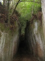
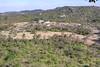
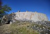
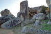
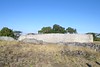
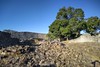
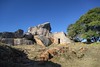
Zimbabwe seems to be a bit out of interest of main tourist tracks these days, though this country has plenty to offer. Unspoilt south African nature, Victoria Falls and the most important to me...The Great Zimbabwe Ruins.
This ruined city is the exceptional stone monument of its size south of the Sahara. Built between the 11th and 15th centuries by ancestors of the Shona people is now UNESCO World Heritage Site. Two main structures of the place are fortified Acropolis on the hill and the well known Great Enclosure in the valley below.
You may be viewing yesterday's version of this page. To see the most up to date information please register for a free account.
")
")
")
")
Do not use the above information on other web sites or publications without permission of the contributor.
Nearby Images from Flickr
The above images may not be of the site on this page, but were taken nearby. They are loaded from Flickr so please click on them for image credits.
Click here to see more info for this site
Nearby sites
Click here to view sites on an interactive map of the areaKey: Red: member's photo, Blue: 3rd party photo, Yellow: other image, Green: no photo - please go there and take one, Grey: site destroyed
Download sites to:
KML (Google Earth)
GPX (GPS waypoints)
CSV (Garmin/Navman)
CSV (Excel)
To unlock full downloads you need to sign up as a Contributory Member. Otherwise downloads are limited to 50 sites.
Turn off the page maps and other distractions
Nearby sites listing. In the following links * = Image available
253.5km W 264° World's View Matobo National Park* Natural Stone / Erratic / Other Natural Feature
254.7km W 263° Inanke Cave Cave or Rock Shelter
264.8km W 264° Bambata Cave* Cave or Rock Shelter
278.3km SW 217° Machete I Rock Art
480.8km SW 215° Palala River Bluffs San Rock Paintings* Rock Art
596.2km S 182° Bantu stone circles* Standing Stones
602.5km W 266° Makgadikgadi* Ancient Village or Settlement
632.0km NW 308° Sikaunda petroglyphs Rock Art
658.3km S 179° Lion Cavern Ngwenya Ancient Mine, Quarry or other Industry
671.1km SSW 204° African Window* Museum
673.5km SW 227° Matsieng Footprints Rock Art
699.2km SSW 206° Malapa* Cave or Rock Shelter
717.4km SSW 207° Sterkfontein* Cave or Rock Shelter
753.5km NNE 29° Chongoni Rock Art Rock Art
757.9km S 172° Border Cave* Cave or Rock Shelter
920.7km SSW 212° Wolmaransstad Rock Art Rock Art
977.8km W 278° Tsodilo Hills* Rock Art
1021.7km S 187° Kamberg rock art Rock Art
1028.7km S 179° Sibudu Cave* Cave or Rock Shelter
1029.2km SSW 213° Stowlands Rock art Rock Art
1050.4km S 188° Ikanti Shelter I Rock Art
1094.7km SSW 194° Lesob 5 Rock Art
1095.2km SSW 194° Lesob 4 Rock Art
1095.7km SSW 194° Lesob 2 Rock Art
1095.8km SSW 194° Lesob 3 Rock Art
View more nearby sites and additional images


 We would like to know more about this location. Please feel free to add a brief description and any relevant information in your own language.
 Wir möchten mehr über diese Stätte erfahren. Bitte zögern Sie nicht, eine kurze Beschreibung und relevante Informationen in Deutsch hinzuzufügen.
 Nous aimerions en savoir encore un peu sur les lieux. S'il vous plaît n'hesitez pas à ajouter une courte description et tous les renseignements pertinents dans votre propre langue.
 Quisieramos informarnos un poco más de las lugares. No dude en añadir una breve descripción y otros datos relevantes en su propio idioma.