<< Text Pages >> Amenemhat I Pyramid - Pyramid / Mastaba in Egypt in Lower Egypt (North)
Submitted by AlexHunger on Sunday, 18 January 2009 Page Views: 4865
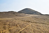
Multi-periodSite Name: Amenemhat I Pyramid Alternative Name: Lisht Pyramid, Amenemhet I PyramidCountry: Egypt
NOTE: This site is 0.655 km away from the location you searched for.
Region: Lower Egypt (North) Type: Pyramid / Mastaba
Nearest Town: Cairo Nearest Village: Lisht
Latitude: 29.574737N Longitude: 31.225047E
Condition:
| 5 | Perfect |
| 4 | Almost Perfect |
| 3 | Reasonable but with some damage |
| 2 | Ruined but still recognisable as an ancient site |
| 1 | Pretty much destroyed, possibly visible as crop marks |
| 0 | No data. |
| -1 | Completely destroyed |
| 5 | Superb |
| 4 | Good |
| 3 | Ordinary |
| 2 | Not Good |
| 1 | Awful |
| 0 | No data. |
| 5 | Can be driven to, probably with disabled access |
| 4 | Short walk on a footpath |
| 3 | Requiring a bit more of a walk |
| 2 | A long walk |
| 1 | In the middle of nowhere, a nightmare to find |
| 0 | No data. |
| 5 | co-ordinates taken by GPS or official recorded co-ordinates |
| 4 | co-ordinates scaled from a detailed map |
| 3 | co-ordinates scaled from a bad map |
| 2 | co-ordinates of the nearest village |
| 1 | co-ordinates of the nearest town |
| 0 | no data |
Internal Links:
External Links:
Pyramid in Lower Egypt (North)
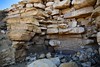
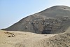
Mud brick pyramid of 12th Dynasyt Middle Kingdom Pharaoh Amenemhat I in the desert just West of Lisht. There are a number of Mastabas surounding it.
You may be viewing yesterday's version of this page. To see the most up to date information please register for a free account.
Do not use the above information on other web sites or publications without permission of the contributor.
Nearby Images from Flickr

The above images may not be of the site on this page, but were taken nearby. They are loaded from Flickr so please click on them for image credits.
Click here to see more info for this site
Nearby sites
Click here to view sites on an interactive map of the areaKey: Red: member's photo, Blue: 3rd party photo, Yellow: other image, Green: no photo - please go there and take one, Grey: site destroyed
Download sites to:
KML (Google Earth)
GPX (GPS waypoints)
CSV (Garmin/Navman)
CSV (Excel)
To unlock full downloads you need to sign up as a Contributory Member. Otherwise downloads are limited to 50 sites.
Turn off the page maps and other distractions
Nearby sites listing. In the following links * = Image available
1.7km SSW 194° Senusret I Pyramid Pyramid / Mastaba
14.1km S 190° Gerzeh cemetery* Barrow Cemetery
18.7km N 358° Mazghuna 2 Pyramid Pyramid / Mastaba
18.8km N 358° Mazghuna 1 Pyramid Pyramid / Mastaba
21.4km SSW 198° Rahotep Mastaba* Chambered Cairn
21.7km SSW 198° Meidum Broken Pyramid* Pyramid / Mastaba
21.7km SSW 198° Meidum Mastaba* Pyramid / Mastaba
23.8km N 356° Queen Hetepheres Pyramid* Pyramid / Mastaba
24.0km N 356° Sneferu's Bent Pyramid* Pyramid / Mastaba
24.1km N 360° Amenemhat III Pyramid at Dashour.* Pyramid / Mastaba
24.5km N 358° Dashour Valley Temple* Ancient Temple
25.9km N 359° Amenmenhat II Pyramid Pyramid / Mastaba
26.1km N 356° Red Pyramid* Pyramid / Mastaba
27.1km SW 218° Seila Pyramid Pyramid / Mastaba
27.2km N 0° Senusret III Pyramid Pyramid / Mastaba
28.4km N 359° Khendjer's Pyramid Pyramid / Mastaba
29.4km N 358° Shepseskaf's Mastaba* Pyramid / Mastaba
29.5km N 358° Pepy II Pyramid* Pyramid / Mastaba
29.7km N 359° Ibi I Pyramid Pyramid / Mastaba
30.7km N 358° Merenre Nemtyemzaf Pyramid Pyramid / Mastaba
30.7km N 5° Memphis Museum* Museum
30.7km N 359° Djedkare Izezi Pyramid Pyramid / Mastaba
31.1km N 359° Pepy I Pyramid* Pyramid / Mastaba
31.8km W 259° Karanis Aushim Temple* Ancient Temple
32.4km N 360° Unas Valley Temple* Ancient Temple
View more nearby sites and additional images


 We would like to know more about this location. Please feel free to add a brief description and any relevant information in your own language.
 Wir möchten mehr über diese Stätte erfahren. Bitte zögern Sie nicht, eine kurze Beschreibung und relevante Informationen in Deutsch hinzuzufügen.
 Nous aimerions en savoir encore un peu sur les lieux. S'il vous plaît n'hesitez pas à ajouter une courte description et tous les renseignements pertinents dans votre propre langue.
 Quisieramos informarnos un poco más de las lugares. No dude en añadir una breve descripción y otros datos relevantes en su propio idioma.