<< Text Pages >> Tira (Ukraine) - Ancient Village or Settlement in Ukraine
Submitted by doctorbiba on Tuesday, 10 April 2012 Page Views: 9566
Multi-periodSite Name: Tira (Ukraine) Alternative Name: TyrasCountry: Ukraine
NOTE: This site is 67.807 km away from the location you searched for.
Type: Ancient Village or Settlement
Nearest Town: Belgorod Dnestrovsky
Latitude: 46.200849N Longitude: 30.351243E
Condition:
| 5 | Perfect |
| 4 | Almost Perfect |
| 3 | Reasonable but with some damage |
| 2 | Ruined but still recognisable as an ancient site |
| 1 | Pretty much destroyed, possibly visible as crop marks |
| 0 | No data. |
| -1 | Completely destroyed |
| 5 | Superb |
| 4 | Good |
| 3 | Ordinary |
| 2 | Not Good |
| 1 | Awful |
| 0 | No data. |
| 5 | Can be driven to, probably with disabled access |
| 4 | Short walk on a footpath |
| 3 | Requiring a bit more of a walk |
| 2 | A long walk |
| 1 | In the middle of nowhere, a nightmare to find |
| 0 | No data. |
| 5 | co-ordinates taken by GPS or official recorded co-ordinates |
| 4 | co-ordinates scaled from a detailed map |
| 3 | co-ordinates scaled from a bad map |
| 2 | co-ordinates of the nearest village |
| 1 | co-ordinates of the nearest town |
| 0 | no data |
Internal Links:
External Links:
Ancient Village or Settlement in Ukraine
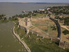
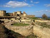
One of the oldest centres of Greek culture, VI century BC, located in the territory of modern Ukraine (Belgorod-Dniester).
Archaeological excavations were carried out only in the last century, mainly by Soviet archaeologists. Last time here, "digging" 20-25 years ago.
The huge stone monoliths of the ancient city of rakushnyaka the local population for a long time, used in construction.
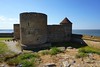
Almost on the spot Tyra, in the XV century defensive fortress was built from the same rakushnyaka, naturally, much was taken out again - with the ruins of ancient Thira.
You may be viewing yesterday's version of this page. To see the most up to date information please register for a free account.
Do not use the above information on other web sites or publications without permission of the contributor.
Nearby Images from Flickr
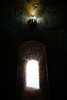
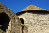
The above images may not be of the site on this page, but were taken nearby. They are loaded from Flickr so please click on them for image credits.
Click here to see more info for this site
Nearby sites
Click here to view sites on an interactive map of the areaKey: Red: member's photo, Blue: 3rd party photo, Yellow: other image, Green: no photo - please go there and take one, Grey: site destroyed
Download sites to:
KML (Google Earth)
GPX (GPS waypoints)
CSV (Garmin/Navman)
CSV (Excel)
To unlock full downloads you need to sign up as a Contributory Member. Otherwise downloads are limited to 50 sites.
Turn off the page maps and other distractions
Nearby sites listing. In the following links * = Image available
50.3km NE 34° Kuyalnik Temple Ancient Temple
130.9km ENE 65° Olbia Ancient Village or Settlement
142.7km ENE 72° Kherson Cliffs* Natural Stone / Erratic / Other Natural Feature
147.9km NW 309° National Museum of History of Moldova* Museum
164.3km W 280° Upper Trajan's Wall Misc. Earthwork
182.6km SW 230° Telita-Celic Dere* Barrow Cemetery
193.4km NNE 18° Yuzhnoukrainsk Cromlech* Chambered Cairn
194.5km SW 215° Argamum* Ancient Village or Settlement
211.2km N 8° Mohyla Blyzniuky Burial Mound Round Barrow(s)
214.7km N 9° Mohyla-Hostra Burial Mound Round Barrow(s)
217.3km SW 214° Fertility menhir* Standing Stone (Menhir)
219.7km SW 215° Istria burial site* Barrow Cemetery
221.3km SW 214° Histria* Ancient Village or Settlement
221.6km SW 214° Histria Museum of History* Museum
231.4km ESE 115° Modern Stonehenge on the beach at Popovka Modern Stone Circle etc
259.3km SW 224° Capidava* Ancient Village or Settlement
261.5km SSW 211° Constanta Museum of National History and Archaeology* Museum
289.4km NW 309° Buteşti, Moldova* Cave or Rock Shelter
294.5km NNE 29° Stone Babas on Dvortsova Street* Carving
299.3km SSW 208° Callatis* Ancient Village or Settlement
299.4km SSW 208° Callatis Museum of Archaeology Museum
299.6km SW 220° Tropaeum Traiani* Sculptured Stone
301.2km SW 220° Adamclisi Museum of Antiquities* Museum
302.3km SE 125° Chersonesus* Ancient Village or Settlement
314.2km WSW 256° Turtudui menhir* Standing Stone (Menhir)
View more nearby sites and additional images


 We would like to know more about this location. Please feel free to add a brief description and any relevant information in your own language.
 Wir möchten mehr über diese Stätte erfahren. Bitte zögern Sie nicht, eine kurze Beschreibung und relevante Informationen in Deutsch hinzuzufügen.
 Nous aimerions en savoir encore un peu sur les lieux. S'il vous plaît n'hesitez pas à ajouter une courte description et tous les renseignements pertinents dans votre propre langue.
 Quisieramos informarnos un poco más de las lugares. No dude en añadir una breve descripción y otros datos relevantes en su propio idioma.