<< Our Photo Pages >> Mausoleum Lanuéjols - Ancient Temple in France in Languedoc:Lozère (48)
Submitted by johnstone on Tuesday, 30 October 2018 Page Views: 798
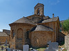
Multi-periodSite Name: Mausoleum Lanuéjols Alternative Name: Mausolée des PomponiiCountry: France Département: Languedoc:Lozère (48) Type: Ancient Temple
Nearest Town: Lanuéjols Nearest Village: Lanuéjols
Latitude: 44.500000N Longitude: 3.571400E
Condition:
| 5 | Perfect |
| 4 | Almost Perfect |
| 3 | Reasonable but with some damage |
| 2 | Ruined but still recognisable as an ancient site |
| 1 | Pretty much destroyed, possibly visible as crop marks |
| 0 | No data. |
| -1 | Completely destroyed |
| 5 | Superb |
| 4 | Good |
| 3 | Ordinary |
| 2 | Not Good |
| 1 | Awful |
| 0 | No data. |
| 5 | Can be driven to, probably with disabled access |
| 4 | Short walk on a footpath |
| 3 | Requiring a bit more of a walk |
| 2 | A long walk |
| 1 | In the middle of nowhere, a nightmare to find |
| 0 | No data. |
| 5 | co-ordinates taken by GPS or official recorded co-ordinates |
| 4 | co-ordinates scaled from a detailed map |
| 3 | co-ordinates scaled from a bad map |
| 2 | co-ordinates of the nearest village |
| 1 | co-ordinates of the nearest town |
| 0 | no data |
Internal Links:
External Links:
I have visited· I would like to visit
rrmoser would like to visit
johnstone visited on 11th Jul 2007 - their rating: Cond: 3 Amb: 4 Access: 5
")
Gallo-Roman mausoleum, built in the third century, in memory of an important family.
Wikipedia (Article in French)
Lieux Insolites (Description and pictures)
Base Mérimée (Historic Monument)
Base Mérimée (Patrimonial Inventory)
You may be viewing yesterday's version of this page. To see the most up to date information please register for a free account.
")
")
Do not use the above information on other web sites or publications without permission of the contributor.
Nearby Images from Flickr

The above images may not be of the site on this page, but were taken nearby. They are loaded from Flickr so please click on them for image credits.
Click here to see more info for this site
Nearby sites
Click here to view sites on an interactive map of the areaKey: Red: member's photo, Blue: 3rd party photo, Yellow: other image, Green: no photo - please go there and take one, Grey: site destroyed
Download sites to:
KML (Google Earth)
GPX (GPS waypoints)
CSV (Garmin/Navman)
CSV (Excel)
To unlock full downloads you need to sign up as a Contributory Member. Otherwise downloads are limited to 50 sites.
Turn off the page maps and other distractions
Nearby sites listing. In the following links * = Image available
1.2km SW 234° Menhir du Boy* Standing Stone (Menhir)
2.2km SSW 200° Dolmen de la Blachère Burial Chamber or Dolmen
4.3km N 9° Dolmen de la Rouvière (Pelouse) Burial Chamber or Dolmen
4.5km SE 128° Menhir de Brajon Standing Stone (Menhir)
5.8km E 93° Menhir de l'Oustel-Cremat* Standing Stone (Menhir)
6.8km N 353° Dolmen du Féron Burial Chamber or Dolmen
7.5km E 94° Menhir de la Fergère* Standing Stone (Menhir)
7.9km S 172° Menhir de la Borie 2 Standing Stone (Menhir)
8.9km SW 222° Fraissinel Dolmen* Burial Chamber or Dolmen
8.9km NNE 16° Dolmen de la Tailladisse* Burial Chamber or Dolmen
9.0km S 172° Menhir de la Borie 1* Standing Stone (Menhir)
9.0km S 173° Menhirs de la Fage A* Standing Stones
9.1km S 173° Menhir de la Fage A08* Standing Stone (Menhir)
9.2km SW 222° Menhir de Fraissinel* Standing Stone (Menhir)
9.2km W 272° Dolmen de la Couronne de Mende Burial Chamber or Dolmen
9.3km S 173° Menhir de la Fage A07* Standing Stone (Menhir)
9.3km S 174° Menhir de la Fage A06* Standing Stone (Menhir)
9.3km S 174° Menhir de la Fage A05* Standing Stone (Menhir)
9.3km SSW 194° Montmirat menhirs* Standing Stones
9.4km S 174° Menhir de la Fage A04* Standing Stone (Menhir)
9.5km S 169° Menhir de la Fage B11* Standing Stone (Menhir)
9.6km S 169° Pierre des Trois Communes* Standing Stone (Menhir)
9.6km S 169° Menhirs de la Fage B* Standing Stones
9.6km S 170° Menhir de la Fage B01* Standing Stone (Menhir)
9.6km S 170° Menhir de la Fage B02* Standing Stone (Menhir)
View more nearby sites and additional images


 We would like to know more about this location. Please feel free to add a brief description and any relevant information in your own language.
 Wir möchten mehr über diese Stätte erfahren. Bitte zögern Sie nicht, eine kurze Beschreibung und relevante Informationen in Deutsch hinzuzufügen.
 Nous aimerions en savoir encore un peu sur les lieux. S'il vous plaît n'hesitez pas à ajouter une courte description et tous les renseignements pertinents dans votre propre langue.
 Quisieramos informarnos un poco más de las lugares. No dude en añadir una breve descripción y otros datos relevantes en su propio idioma.