

<< Our Photo Pages >> Cala Sant Vincenc - Cave or Rock Shelter in Spain in Balearic Isles (Mallorca / Majorca)
Submitted by TimPrevett on Wednesday, 20 April 2011 Page Views: 11806
Natural PlacesSite Name: Cala Sant VincencCountry: Spain Region: Balearic Isles (Mallorca / Majorca) Type: Cave or Rock Shelter
Nearest Village: Cala St Vincenc
Latitude: 39.915170N Longitude: 3.048000E
Condition:
| 5 | Perfect |
| 4 | Almost Perfect |
| 3 | Reasonable but with some damage |
| 2 | Ruined but still recognisable as an ancient site |
| 1 | Pretty much destroyed, possibly visible as crop marks |
| 0 | No data. |
| -1 | Completely destroyed |
| 5 | Superb |
| 4 | Good |
| 3 | Ordinary |
| 2 | Not Good |
| 1 | Awful |
| 0 | No data. |
| 5 | Can be driven to, probably with disabled access |
| 4 | Short walk on a footpath |
| 3 | Requiring a bit more of a walk |
| 2 | A long walk |
| 1 | In the middle of nowhere, a nightmare to find |
| 0 | No data. |
| 5 | co-ordinates taken by GPS or official recorded co-ordinates |
| 4 | co-ordinates scaled from a detailed map |
| 3 | co-ordinates scaled from a bad map |
| 2 | co-ordinates of the nearest village |
| 1 | co-ordinates of the nearest town |
| 0 | no data |
Internal Links:
External Links:
")
Our time at Cala St Vincenc was a time of happy surprises. We did not know entirely what to expect by ‘prehistoric caves’ by the road signs, so the sense of discovery was very acute.
Knowing that there was a talaiotic column just on entering the village, we approached the village carefully watching the signs and avoiding the huge groups of cyclists which render slow and attentive driving particularly necessary quite frequently on Mallorca.
The signs directed us to the right, and almost immediately we observed the megalith on the left hand corner of Carrer de Joaquim Sorolla and Carrer Dionis Bennassar. Pulling over on to the left side of the road, and crossing over, we found a very aged and weathered interpretation panel in Spanish, German and English. The text was worn and not entirely legible but the map was invaluable for working what was where.
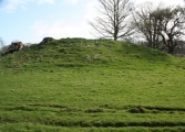
Some 11 caves form the necropolis. Cave 1 was across the road by some distance and not accessible as far as we could work out. Cave 5 was immediately across and down from caves 6, 7 and 8. What remains of caves 2, 3, and 4 is not given.
Cave 5 is quite disappointing - its cross section revealed by standing on the bank across the road, as there is no roof, so it is an overgrown hole, essentially. For the rest of the caves a torch will be an enormous help.
Caves 6, 7, 8 form a cluster immediately next to each other and are quite delightful to explore. Number 6 is high enough to walk in to and recesses some distance, with a long thin rectangle cut into its centre.
Cave 7 is a squeeze to enter. Muddy hands, knees and shins will be gained! Two small rectangular apertures linked by a small passage give entry to a very long carved out chamber, with a long thin rectangle cut into the centre, and a circular pit about three feet deep at the furthest end. My sun hat fell into the pit, and I had to climb in to retrieve it. I didn’t particularly relish that, but it had to be done. There is a ledge on either side of the cave, and a smaller chamber on either side near the entrance, giving it something of a phallic plan layout. The ceilings were curved too - wondering if that’s related to the boat shaped graves on other built graves on the island?
Cave 8 would have had two apertures as cave 7, except the ceiling above the first aperture and linking passage has been removed. A small chamber midway along on the right and another long thin rectangular depression help define the interior.
The whole area in front of caves 6, 7 and 8 looks like it was once part of the complex, so the entrances to each may well have been longer and several feet more recessed than they are now.
Cave 9 is just a little further around on the left, an exposed passage like cave 8, a long thin rectangular inset, with four smaller chambers - one on the far left, one opposite the entrance at the far end, and two on the right hand side at the end furthest from the entrance.
Cave 10 is a more typical cave shape, a wide walk in entrance, and looked like it may have been used for habitation long after any use for burials.
Cave 11 is the furthest on the left from the megalithic monument, and is a smaller version of cave 10 - a walk entrance and not much (obvious) detail to look at.
Note: Many photos and information for this Mallorcan prehistoric burial site now on The Megalithic Portal.
You may be viewing yesterday's version of this page. To see the most up to date information please register for a free account.
")
")
")
")
")
")
")
")
")
")
")
")
")
")
")
")
")
")
")
")
")
")
")
")
These are just the first 25 photos of Cala Sant Vincenc. If you log in with a free user account you will be able to see our entire collection.
Do not use the above information on other web sites or publications without permission of the contributor.
Click here to see more info for this site
Nearby sites
Click here to view sites on an interactive map of the areaKey: Red: member's photo, Blue: 3rd party photo, Yellow: other image, Green: no photo - please go there and take one, Grey: site destroyed
Download sites to:
KML (Google Earth)
GPX (GPS waypoints)
CSV (Garmin/Navman)
CSV (Excel)
To unlock full downloads you need to sign up as a Contributory Member. Otherwise downloads are limited to 50 sites.
Turn off the page maps and other distractions
Nearby sites listing. In the following links * = Image available
2.7km E 82° Bocchoris* Ancient Village or Settlement
18.3km SSE 165° Son Serra (Can Picafort)* Ancient Village or Settlement
18.4km S 174° Talaiot de Sa Font* Broch or Nuraghe
20.2km SSE 152° Son Bauló D'Alt* Burial Chamber or Dolmen
21.2km SSE 147° Son Real Necropolis* Barrow Cemetery
21.5km SE 146° Illot des Parros Necropolis* Barrow Cemetery
21.6km SSE 147° Sa Coveta* Burial Chamber or Dolmen
23.0km WSW 238° Almallutx Stone* Ancient Village or Settlement
23.0km WSW 237° Almallutx Sanctuary* Ancient Village or Settlement
23.4km SSE 150° Es Figueral* Ancient Village or Settlement
25.0km S 188° Es Racons* Broch or Nuraghe
25.3km SSE 147° Son Serra de Marina* Broch or Nuraghe
27.8km SW 221° Es Castellot Ancient Village or Settlement
28.5km SE 130° Aigua Dolça* Burial Chamber or Dolmen
29.0km SE 141° Sa Clova Des Xot* Broch or Nuraghe
29.3km SE 141° Sa Canova de Morell* Broch or Nuraghe
30.7km SSW 199° Son Corro* Ancient Village or Settlement
30.8km SSW 202° Son Fred* Broch or Nuraghe
31.6km SSW 195° Es Turassot* Ancient Village or Settlement
32.0km SSW 202° Camp del Bisbe* Cave or Rock Shelter
32.0km SSW 197° Binifat* Broch or Nuraghe
36.4km SE 134° Ses Paisses* Ancient Village or Settlement
37.0km S 189° Campanari des Moros* Broch or Nuraghe
37.5km S 191° Son Fornes Settlement* Ancient Village or Settlement
38.6km S 188° Archaeological Museum of Son Fornés* Museum
View more nearby sites and additional images


 We would like to know more about this location. Please feel free to add a brief description and any relevant information in your own language.
 Wir möchten mehr über diese Stätte erfahren. Bitte zögern Sie nicht, eine kurze Beschreibung und relevante Informationen in Deutsch hinzuzufügen.
 Nous aimerions en savoir encore un peu sur les lieux. S'il vous plaît n'hesitez pas à ajouter une courte description et tous les renseignements pertinents dans votre propre langue.
 Quisieramos informarnos un poco más de las lugares. No dude en añadir una breve descripción y otros datos relevantes en su propio idioma.