<< Image Pages >> African Window - Museum in South Africa
Submitted by durhamnature on Tuesday, 19 March 2013 Page Views: 4176
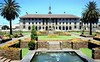
MuseumsSite Name: African Window Alternative Name: Ditsong National Museum of Cultural HistoryCountry: South Africa
NOTE: This site is 170.26 km away from the location you searched for.
Type: Museum
Nearest Town: Pretoria
Latitude: 25.752694S Longitude: 28.184916E
Condition:
| 5 | Perfect |
| 4 | Almost Perfect |
| 3 | Reasonable but with some damage |
| 2 | Ruined but still recognisable as an ancient site |
| 1 | Pretty much destroyed, possibly visible as crop marks |
| 0 | No data. |
| -1 | Completely destroyed |
| 5 | Superb |
| 4 | Good |
| 3 | Ordinary |
| 2 | Not Good |
| 1 | Awful |
| 0 | No data. |
| 5 | Can be driven to, probably with disabled access |
| 4 | Short walk on a footpath |
| 3 | Requiring a bit more of a walk |
| 2 | A long walk |
| 1 | In the middle of nowhere, a nightmare to find |
| 0 | No data. |
| 5 | co-ordinates taken by GPS or official recorded co-ordinates |
| 4 | co-ordinates scaled from a detailed map |
| 3 | co-ordinates scaled from a bad map |
| 2 | co-ordinates of the nearest village |
| 1 | co-ordinates of the nearest town |
| 0 | no data |
Internal Links:
External Links:
")
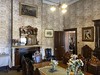
Large archaeology collection.
Opening times: 8am to 4pm daily, there is an admission charge.
Address: 149 Visagie Street, Pretoria 0002
Telephone: 012 324 6082
Website: National Cultural History Museum
You may be viewing yesterday's version of this page. To see the most up to date information please register for a free account.
Do not use the above information on other web sites or publications without permission of the contributor.
davidmorgan has found this location on Google Street View:
Nearby Images from Flickr


The above images may not be of the site on this page, but were taken nearby. They are loaded from Flickr so please click on them for image credits.
Click here to see more info for this site
Nearby sites
Click here to view sites on an interactive map of the areaKey: Red: member's photo, Blue: 3rd party photo, Yellow: other image, Green: no photo - please go there and take one, Grey: site destroyed
Download sites to:
KML (Google Earth)
GPX (GPS waypoints)
CSV (Garmin/Navman)
CSV (Excel)
To unlock full downloads you need to sign up as a Contributory Member. Otherwise downloads are limited to 50 sites.
Turn off the page maps and other distractions
Nearby sites listing. In the following links * = Image available
37.3km WSW 248° Malapa* Cave or Rock Shelter
53.7km WSW 237° Sterkfontein* Cave or Rock Shelter
216.1km N 2° Palala River Bluffs San Rock Paintings* Rock Art
258.4km E 88° Bantu stone circles* Standing Stones
262.1km NW 306° Matsieng Footprints Rock Art
272.6km SW 233° Wolmaransstad Rock Art Rock Art
288.6km E 100° Lion Cavern Ngwenya Ancient Mine, Quarry or other Industry
381.3km SW 230° Stowlands Rock art Rock Art
404.2km ESE 111° Border Cave* Cave or Rock Shelter
405.2km NNE 16° Machete I Rock Art
429.7km SSE 161° Kamberg rock art Rock Art
448.7km SSE 164° Ikanti Shelter I Rock Art
451.4km S 179° Lesob 5 Rock Art
451.9km S 179° Lesob 4 Rock Art
452.3km S 179° Lesob 2 Rock Art
452.4km S 179° Lesob 3 Rock Art
452.9km S 179° Lesob 1 Rock Art
473.6km SW 225° McGregor Museum Museum
474.7km SW 227° Nooitgedacht Rock art Rock Art
476.6km SW 226° Wildebeestkuil* Rock Art
507.3km SSE 146° Sibudu Cave* Cave or Rock Shelter
515.1km WSW 242° Wonderwerk Cave* Cave or Rock Shelter
527.0km SW 227° Driekopseiland Rock Art Rock Art
554.0km WSW 246° Kathu Pan* Ancient Mine, Quarry or other Industry
557.7km SW 222° Thomas' Farm Belmont Rock Art Rock Art
View more nearby sites and additional images


 We would like to know more about this location. Please feel free to add a brief description and any relevant information in your own language.
 Wir möchten mehr über diese Stätte erfahren. Bitte zögern Sie nicht, eine kurze Beschreibung und relevante Informationen in Deutsch hinzuzufügen.
 Nous aimerions en savoir encore un peu sur les lieux. S'il vous plaît n'hesitez pas à ajouter une courte description et tous les renseignements pertinents dans votre propre langue.
 Quisieramos informarnos un poco más de las lugares. No dude en añadir una breve descripción y otros datos relevantes en su propio idioma.