<< Our Photo Pages >> Capidava - Ancient Village or Settlement in Romania
Submitted by mfrincu on Friday, 21 August 2015 Page Views: 1481
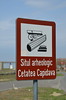
Multi-periodSite Name: CapidavaCountry: Romania
NOTE: This site is 64.53 km away from the location you searched for.
Type: Ancient Village or Settlement
Nearest Town: Cernavoda Nearest Village: Capidava
Latitude: 44.493611N Longitude: 28.090278E
Condition:
| 5 | Perfect |
| 4 | Almost Perfect |
| 3 | Reasonable but with some damage |
| 2 | Ruined but still recognisable as an ancient site |
| 1 | Pretty much destroyed, possibly visible as crop marks |
| 0 | No data. |
| -1 | Completely destroyed |
| 5 | Superb |
| 4 | Good |
| 3 | Ordinary |
| 2 | Not Good |
| 1 | Awful |
| 0 | No data. |
| 5 | Can be driven to, probably with disabled access |
| 4 | Short walk on a footpath |
| 3 | Requiring a bit more of a walk |
| 2 | A long walk |
| 1 | In the middle of nowhere, a nightmare to find |
| 0 | No data. |
| 5 | co-ordinates taken by GPS or official recorded co-ordinates |
| 4 | co-ordinates scaled from a detailed map |
| 3 | co-ordinates scaled from a bad map |
| 2 | co-ordinates of the nearest village |
| 1 | co-ordinates of the nearest town |
| 0 | no data |
Internal Links:
External Links:
I have visited· I would like to visit
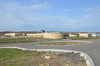
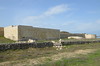
mfrincu saw from a distance on 20th Aug 2015 - their rating: Cond: 3 Amb: 4 Access: 4 The site is being reconditioned and cannot be visited. Estimated completion time is end of 2015.
")
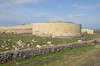
The name of the place is Getic meaning the "curve fortified settlement". Historians believe that the castrum was built over an existing geto-dacian settlement. This is based on the literary evidences that confirms both the existence and the importance of Capidava and also based on the archaeological pre-Roman evidences, some take into consideration the hypothesis that the Getic fortress might have been razed to the ground through the building of the Roman castra itself.
Historians have identified the Geto-Dacian Capidava as the center of power for the Getic king Dapyx, within a territorium Capidavense. Cassius Dio's Historia Romana makes mention of the retreat of Dapyx into his fort after his defeat in 28 BC at the hand of Marcus Licinius Crassus. The fort mentioned by Dio was identified with future Roman fort Capidava, based on the locations described in the ancient source.
Also, on the site of modern Capidava village (a few meters away), there is a La Tène settlement of Geto-Dacian culture, dated to 5th century - 2nd century BC. 4 km south of Capidava, on the bank of Zaval Valley, there are strong Geto-Dacian traces, dating back to the second period of Iron Age. Beside the Geto-Dacian ceramic, fragments of Roman vases are scattered around.
Source: wikipedia
You may be viewing yesterday's version of this page. To see the most up to date information please register for a free account.
Do not use the above information on other web sites or publications without permission of the contributor.
Nearby Images from Flickr
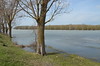
The above images may not be of the site on this page, but were taken nearby. They are loaded from Flickr so please click on them for image credits.
Click here to see more info for this site
Nearby sites
Click here to view sites on an interactive map of the areaKey: Red: member's photo, Blue: 3rd party photo, Yellow: other image, Green: no photo - please go there and take one, Grey: site destroyed
Download sites to:
KML (Google Earth)
GPX (GPS waypoints)
CSV (Garmin/Navman)
CSV (Excel)
To unlock full downloads you need to sign up as a Contributory Member. Otherwise downloads are limited to 50 sites.
Turn off the page maps and other distractions
Nearby sites listing. In the following links * = Image available
44.9km SSW 194° Tropaeum Traiani* Sculptured Stone
46.7km SSW 194° Adamclisi Museum of Antiquities* Museum
53.4km E 80° Istria burial site* Barrow Cemetery
54.2km E 84° Histria Museum of History* Museum
54.6km E 83° Histria* Ancient Village or Settlement
57.5km SE 128° Constanta Museum of National History and Archaeology* Museum
58.0km E 81° Fertility menhir* Standing Stone (Menhir)
73.4km ENE 66° Argamum* Ancient Village or Settlement
80.6km NNE 27° Telita-Celic Dere* Barrow Cemetery
84.9km SSE 152° Callatis* Ancient Village or Settlement
85.0km SSE 152° Callatis Museum of Archaeology Museum
121.1km S 177° Cybele Temple* Ancient Temple
134.5km SW 232° Sveshtari Thracian Tomb* Chambered Cairn
143.7km S 186° Varna Museum of Archaeology Museum
144.3km SSW 192° Pobiti Kamani* Natural Stone / Erratic / Other Natural Feature
144.9km SSW 212° Pliska Mound Artificial Mound
145.0km W 267° Cernica Neolithic Tombs* Barrow Cemetery
148.5km SSW 212° Pliska Menhirs* Standing Stones
158.3km W 268° National Museum of Romanian History Museum
159.7km SSW 198° Solnitsata* Ancient Village or Settlement
165.7km NW 309° Turtudui menhir* Standing Stone (Menhir)
166.0km NW 309° Menhir near Fundul Pesterii* Standing Stone (Menhir)
166.0km NW 309° Fundul Pesterii Cave* Rock Art
206.1km S 188° Nesebar Necropolis* Burial Chamber or Dolmen
217.9km N 3° Upper Trajan's Wall Misc. Earthwork
View more nearby sites and additional images


 We would like to know more about this location. Please feel free to add a brief description and any relevant information in your own language.
 Wir möchten mehr über diese Stätte erfahren. Bitte zögern Sie nicht, eine kurze Beschreibung und relevante Informationen in Deutsch hinzuzufügen.
 Nous aimerions en savoir encore un peu sur les lieux. S'il vous plaît n'hesitez pas à ajouter une courte description et tous les renseignements pertinents dans votre propre langue.
 Quisieramos informarnos un poco más de las lugares. No dude en añadir una breve descripción y otros datos relevantes en su propio idioma.