<< Text Pages >> Ukonkivi - Round Cairn in Finland
Submitted by bat400 on Friday, 25 June 2010 Page Views: 5215
Neolithic and Bronze AgeSite Name: Ukonkivi Alternative Name: Ukko's StoneCountry: Finland
NOTE: This site is 101.747 km away from the location you searched for.
Type: Round Cairn
Nearest Village: Inari
Latitude: 68.939000N Longitude: 27.292000E
Condition:
| 5 | Perfect |
| 4 | Almost Perfect |
| 3 | Reasonable but with some damage |
| 2 | Ruined but still recognisable as an ancient site |
| 1 | Pretty much destroyed, possibly visible as crop marks |
| 0 | No data. |
| -1 | Completely destroyed |
| 5 | Superb |
| 4 | Good |
| 3 | Ordinary |
| 2 | Not Good |
| 1 | Awful |
| 0 | No data. |
| 5 | Can be driven to, probably with disabled access |
| 4 | Short walk on a footpath |
| 3 | Requiring a bit more of a walk |
| 2 | A long walk |
| 1 | In the middle of nowhere, a nightmare to find |
| 0 | No data. |
| 5 | co-ordinates taken by GPS or official recorded co-ordinates |
| 4 | co-ordinates scaled from a detailed map |
| 3 | co-ordinates scaled from a bad map |
| 2 | co-ordinates of the nearest village |
| 1 | co-ordinates of the nearest town |
| 0 | no data |
Be the first person to rate this site - see the 'Contribute!' box in the right hand menu.
Internal Links:
External Links:
Round Cairn in Northern Finland.A stone arrangement in shallow water off Ukonsaari Island in lake Inari, Finnish Lapland. Ukko is the ancient Finnish Thunder God. The island is considered a holy place by the Sami people.
You may be viewing yesterday's version of this page. To see the most up to date information please register for a free account.
Do not use the above information on other web sites or publications without permission of the contributor.
Nearby Images from Flickr
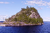
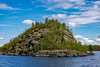
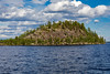

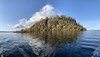

The above images may not be of the site on this page, but were taken nearby. They are loaded from Flickr so please click on them for image credits.
Click here to see more info for this site
Nearby sites
Click here to view sites on an interactive map of the areaKey: Red: member's photo, Blue: 3rd party photo, Yellow: other image, Green: no photo - please go there and take one, Grey: site destroyed
Download sites to:
KML (Google Earth)
GPX (GPS waypoints)
CSV (Garmin/Navman)
CSV (Excel)
To unlock full downloads you need to sign up as a Contributory Member. Otherwise downloads are limited to 50 sites.
Turn off the page maps and other distractions
Nearby sites listing. In the following links * = Image available
188.6km NW 310° Transfardalen* Cave or Rock Shelter
195.0km NW 309° Amtmannsnes* Carving
195.4km NW 309° Komsa sacrificial site* Natural Stone / Erratic / Other Natural Feature
195.6km NW 307° Hjemmeluft stone age settlement* Ancient Village or Settlement
195.7km NW 307° Alta (Norway)* Rock Art
200.7km NW 312° Kviby sacrificial site* Natural Stone / Erratic / Other Natural Feature
200.9km ENE 59° Dva Brata Natural Stone / Erratic / Other Natural Feature
201.3km NW 313° Slottsbergkjerringa* Natural Stone / Erratic / Other Natural Feature
202.3km NW 310° Djupvika sacrificial site* Natural Stone / Erratic / Other Natural Feature
218.8km NW 325° Stallogargo sacrificial site* Natural Stone / Erratic / Other Natural Feature
220.4km ENE 77° Seids Ura-Guba* Natural Stone / Erratic / Other Natural Feature
230.1km E 87° Crow Stone complex* Stone Circle
238.1km SW 225° Kaunisvaara Settlements Ancient Village or Settlement
295.9km SE 131° Kandalaksha* Turf Maze
307.3km WNW 288° Skarmunken* Natural Stone / Erratic / Other Natural Feature
307.6km W 279° Nordkjosbotn sacrificial site* Natural Stone / Erratic / Other Natural Feature
317.5km W 281° Balsfjord rock carvings* Carving
335.0km W 279° Mårfjellskardet sacrificial site* Natural Stone / Erratic / Other Natural Feature
338.2km WNW 287° University Museum, Tromso* Museum
342.6km SW 217° Lillberget* Ancient Village or Settlement
343.4km WNW 286° Skavberget* Rock Art
344.1km WNW 287° Håkøya* Ancient Village or Settlement
350.4km SSW 196° Jatulinlehto Giant's Church Stone Fort or Dun
353.8km SE 124° Lake Kanozero* Carving
363.6km WNW 284° Greipstad* Ancient Village or Settlement
View more nearby sites and additional images


 We would like to know more about this location. Please feel free to add a brief description and any relevant information in your own language.
 Wir möchten mehr über diese Stätte erfahren. Bitte zögern Sie nicht, eine kurze Beschreibung und relevante Informationen in Deutsch hinzuzufügen.
 Nous aimerions en savoir encore un peu sur les lieux. S'il vous plaît n'hesitez pas à ajouter une courte description et tous les renseignements pertinents dans votre propre langue.
 Quisieramos informarnos un poco más de las lugares. No dude en añadir una breve descripción y otros datos relevantes en su propio idioma.