<< Other Photo Pages >> Sveshtari Thracian Tomb - Chambered Cairn in Bulgaria
Submitted by AlexHunger on Monday, 24 July 2006 Page Views: 8142
Neolithic and Bronze AgeSite Name: Sveshtari Thracian TombCountry: Bulgaria
NOTE: This site is 50.085 km away from the location you searched for.
Type: Chambered Cairn
Nearest Town: Razgrad Nearest Village: Jasenovec
Latitude: 43.745024N Longitude: 26.766900E
Condition:
| 5 | Perfect |
| 4 | Almost Perfect |
| 3 | Reasonable but with some damage |
| 2 | Ruined but still recognisable as an ancient site |
| 1 | Pretty much destroyed, possibly visible as crop marks |
| 0 | No data. |
| -1 | Completely destroyed |
| 5 | Superb |
| 4 | Good |
| 3 | Ordinary |
| 2 | Not Good |
| 1 | Awful |
| 0 | No data. |
| 5 | Can be driven to, probably with disabled access |
| 4 | Short walk on a footpath |
| 3 | Requiring a bit more of a walk |
| 2 | A long walk |
| 1 | In the middle of nowhere, a nightmare to find |
| 0 | No data. |
| 5 | co-ordinates taken by GPS or official recorded co-ordinates |
| 4 | co-ordinates scaled from a detailed map |
| 3 | co-ordinates scaled from a bad map |
| 2 | co-ordinates of the nearest village |
| 1 | co-ordinates of the nearest town |
| 0 | no data |
Internal Links:
External Links:
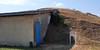
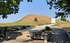
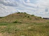
Chambered Cairn in Bulgaria
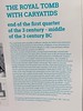
3rd century B.C. Tumulus with long dromos, chamber, 2 funerary beds as well as polychrome half-human, half-plant caryatids and painted murals.
A UNESCO World Heritage Site.
You may be viewing yesterday's version of this page. To see the most up to date information please register for a free account.
Do not use the above information on other web sites or publications without permission of the contributor.
davidmorgan has found this location on Google Street View:
Nearby Images from Flickr
The above images may not be of the site on this page, but were taken nearby. They are loaded from Flickr so please click on them for image credits.
Click here to see more info for this site
Nearby sites
Click here to view sites on an interactive map of the areaKey: Red: member's photo, Blue: 3rd party photo, Yellow: other image, Green: no photo - please go there and take one, Grey: site destroyed
Download sites to:
KML (Google Earth)
GPX (GPS waypoints)
CSV (Garmin/Navman)
CSV (Excel)
To unlock full downloads you need to sign up as a Contributory Member. Otherwise downloads are limited to 50 sites.
Turn off the page maps and other distractions
Nearby sites listing. In the following links * = Image available
49.3km SE 143° Pliska Mound Artificial Mound
51.5km SSE 147° Pliska Menhirs* Standing Stones
84.7km NNW 332° Cernica Neolithic Tombs* Barrow Cemetery
89.1km SE 140° Solnitsata* Ancient Village or Settlement
93.2km NW 325° National Museum of Romanian History Museum
95.3km SE 127° Pobiti Kamani* Natural Stone / Erratic / Other Natural Feature
102.2km ENE 68° Adamclisi Museum of Antiquities* Museum
103.1km ENE 67° Tropaeum Traiani* Sculptured Stone
110.2km ESE 122° Varna Museum of Archaeology Museum
119.0km ESE 108° Cybele Temple* Ancient Temple
134.5km NE 51° Capidava* Ancient Village or Settlement
134.9km S 190° Cabyle* Ancient Village or Settlement
136.6km W 275° Crangu Artifical Mounds* Artificial Mound
143.5km SSE 147° Nesebar Necropolis* Burial Chamber or Dolmen
146.0km E 86° Callatis* Ancient Village or Settlement
146.0km E 86° Callatis Museum of Archaeology Museum
158.7km ENE 72° Constanta Museum of National History and Archaeology* Museum
162.9km SW 225° Shushmanets mound Chambered Tomb
163.1km SW 225° Helvetia mound Chambered Tomb
163.2km SW 225° Griffins mound Chambered Tomb
163.5km S 185° Baalar Kayryak Artificial Mound
163.5km SW 224° Sarafova mound Chambered Tomb
164.1km SW 225° Ostrusha mound* Chambered Tomb
164.2km SW 224° Kran Bronze Age sanctuary Ancient Village or Settlement
164.3km SW 225° Goliama Kosmatka mound* Ancient Temple
View more nearby sites and additional images


 We would like to know more about this location. Please feel free to add a brief description and any relevant information in your own language.
 Wir möchten mehr über diese Stätte erfahren. Bitte zögern Sie nicht, eine kurze Beschreibung und relevante Informationen in Deutsch hinzuzufügen.
 Nous aimerions en savoir encore un peu sur les lieux. S'il vous plaît n'hesitez pas à ajouter une courte description et tous les renseignements pertinents dans votre propre langue.
 Quisieramos informarnos un poco más de las lugares. No dude en añadir una breve descripción y otros datos relevantes en su propio idioma.