<< Text Pages >> Klopedi Temples - Ancient Temple in Greece in Greek Islands
Submitted by AlexHunger on Saturday, 06 October 2007 Page Views: 6023
Neolithic and Bronze AgeSite Name: Klopedi TemplesCountry: Greece
NOTE: This site is 8.779 km away from the location you searched for.
Region: Greek Islands Type: Ancient Temple
Nearest Town: Ayía Paraskevi Nearest Village: Klopedi
Latitude: 39.252723N Longitude: 26.243231E
Condition:
| 5 | Perfect |
| 4 | Almost Perfect |
| 3 | Reasonable but with some damage |
| 2 | Ruined but still recognisable as an ancient site |
| 1 | Pretty much destroyed, possibly visible as crop marks |
| 0 | No data. |
| -1 | Completely destroyed |
| 5 | Superb |
| 4 | Good |
| 3 | Ordinary |
| 2 | Not Good |
| 1 | Awful |
| 0 | No data. |
| 5 | Can be driven to, probably with disabled access |
| 4 | Short walk on a footpath |
| 3 | Requiring a bit more of a walk |
| 2 | A long walk |
| 1 | In the middle of nowhere, a nightmare to find |
| 0 | No data. |
| 5 | co-ordinates taken by GPS or official recorded co-ordinates |
| 4 | co-ordinates scaled from a detailed map |
| 3 | co-ordinates scaled from a bad map |
| 2 | co-ordinates of the nearest village |
| 1 | co-ordinates of the nearest town |
| 0 | no data |
Internal Links:
External Links:
Ancient Temples in Greek Islands (Aegean etc)
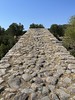
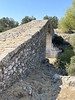
Two side by side temples to unknown deities measuring 27 by 14 metres as well as 38 metres by 16 metres which had 17 by 8 columns. Blocks and capitals have been reused at nearby Byzantine church.
You may be viewing yesterday's version of this page. To see the most up to date information please register for a free account.
Do not use the above information on other web sites or publications without permission of the contributor.
Nearby Images from Flickr


The above images may not be of the site on this page, but were taken nearby. They are loaded from Flickr so please click on them for image credits.
Click here to see more info for this site
Nearby sites
Click here to view sites on an interactive map of the areaKey: Red: member's photo, Blue: 3rd party photo, Yellow: other image, Green: no photo - please go there and take one, Grey: site destroyed
Download sites to:
KML (Google Earth)
GPX (GPS waypoints)
CSV (Garmin/Navman)
CSV (Excel)
To unlock full downloads you need to sign up as a Contributory Member. Otherwise downloads are limited to 50 sites.
Turn off the page maps and other distractions
Nearby sites listing. In the following links * = Image available
8.2km SE 140° Messon Temple of Zeus Ancient Temple
24.0km ESE 111° Thermi (Lesbos)* Ancient Village or Settlement
27.7km NNE 17° Assos Temple of Athena* Ancient Temple
33.5km NNW 341° Chrysa Temple of Sminthian Apollo* Ancient Temple
35.5km N 350° Tuzla* Ancient Temple
52.4km N 3° Neandria Ancient Village or Settlement
53.3km N 1° Koçali* Ancient Mine, Quarry or other Industry
56.0km N 353° Alexandria Troas* Ancient Village or Settlement
58.0km NE 52° Antandros necropolis* Ancient Village or Settlement
58.7km NE 53° Antandros Ancient Village or Settlement
59.2km NE 53° Antandros house* Ancient Village or Settlement
69.2km ESE 120° Candarli Necropolis Chambered Tomb
78.3km N 360° Troy.* Ancient Village or Settlement
78.4km SE 146° Phokaia* Ancient Village or Settlement
80.5km SE 145° Seytan Hamami Rock Cut Tomb
80.8km E 100° Asklepieion* Ancient Temple
81.2km SE 132° Kyme* Ancient Village or Settlement
81.8km E 100° Bergama Archaeological Museum Museum
82.2km E 99° Pergamon* Ancient Village or Settlement
82.6km ESE 101° Bergama Tumulus* Round Barrow(s)
82.8km SE 143° Tas Kule* Rock Cut Tomb
91.6km E 91° Allianoi Ancient Village or Settlement
92.6km SE 139° Panaztepe Ancient Village or Settlement
94.1km SE 133° Larissa (Aeolis) Ancient Village or Settlement
94.2km ESE 120° Aigai.* Ancient Village or Settlement
View more nearby sites and additional images


 We would like to know more about this location. Please feel free to add a brief description and any relevant information in your own language.
 Wir möchten mehr über diese Stätte erfahren. Bitte zögern Sie nicht, eine kurze Beschreibung und relevante Informationen in Deutsch hinzuzufügen.
 Nous aimerions en savoir encore un peu sur les lieux. S'il vous plaît n'hesitez pas à ajouter une courte description et tous les renseignements pertinents dans votre propre langue.
 Quisieramos informarnos un poco más de las lugares. No dude en añadir una breve descripción y otros datos relevantes en su propio idioma.