<< Text Pages >> Saraakallio - Rock Art in Finland
Submitted by KaiHofmann on Saturday, 07 November 2015 Page Views: 1166
Rock ArtSite Name: SaraakallioCountry: Finland
NOTE: This site is 68.885 km away from the location you searched for.
Type: Rock Art
Nearest Town: Laukaa Nearest Village: Rajala
Latitude: 62.417585N Longitude: 25.997243E
Condition:
| 5 | Perfect |
| 4 | Almost Perfect |
| 3 | Reasonable but with some damage |
| 2 | Ruined but still recognisable as an ancient site |
| 1 | Pretty much destroyed, possibly visible as crop marks |
| 0 | No data. |
| -1 | Completely destroyed |
| 5 | Superb |
| 4 | Good |
| 3 | Ordinary |
| 2 | Not Good |
| 1 | Awful |
| 0 | No data. |
| 5 | Can be driven to, probably with disabled access |
| 4 | Short walk on a footpath |
| 3 | Requiring a bit more of a walk |
| 2 | A long walk |
| 1 | In the middle of nowhere, a nightmare to find |
| 0 | No data. |
| 5 | co-ordinates taken by GPS or official recorded co-ordinates |
| 4 | co-ordinates scaled from a detailed map |
| 3 | co-ordinates scaled from a bad map |
| 2 | co-ordinates of the nearest village |
| 1 | co-ordinates of the nearest town |
| 0 | no data |
Internal Links:
External Links:
Rock Art in Finland
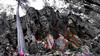
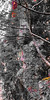
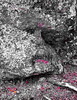
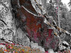
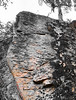
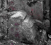
Rock paintings on a large rock at a lakeside east of Laukaa. Until 200 paintings more or less visible could still be found at this site. The oldest are over 6000 years old.
You may be viewing yesterday's version of this page. To see the most up to date information please register for a free account.
Do not use the above information on other web sites or publications without permission of the contributor.
Nearby Images from Flickr
The above images may not be of the site on this page, but were taken nearby. They are loaded from Flickr so please click on them for image credits.
Click here to see more info for this site
Nearby sites
Click here to view sites on an interactive map of the areaKey: Red: member's photo, Blue: 3rd party photo, Yellow: other image, Green: no photo - please go there and take one, Grey: site destroyed
Download sites to:
KML (Google Earth)
GPX (GPS waypoints)
CSV (Garmin/Navman)
CSV (Excel)
To unlock full downloads you need to sign up as a Contributory Member. Otherwise downloads are limited to 50 sites.
Turn off the page maps and other distractions
Nearby sites listing. In the following links * = Image available
111.6km S 179° Liikkuva kivi* Natural Stone / Erratic / Other Natural Feature
135.3km SE 143° Astuvansalmi rock paintings* Rock Art
140.7km NNW 348° Jätinlinna Giant's Church Stone Fort or Dun
155.5km SSW 207° Hovin Manor Stone Rock Art
159.7km W 271° The Devil's Nest (Pirunpesä)* Natural Stone / Erratic / Other Natural Feature
161.5km SW 223° Järvensuo I* Ancient Village or Settlement
163.5km SE 128° Strange rock Kummakivi* Natural Stone / Erratic / Other Natural Feature
169.4km SW 218° Rapola* Hillfort
177.8km SSW 208° Kauriala Uhrikivi Rock Art
178.3km SSE 147° Lemin Heiluvakivi* Natural Stone / Erratic / Other Natural Feature
178.6km WNW 303° Korkeamäki Giant's Church* Stone Fort or Dun
179.9km NW 312° Storbacken Giant's Church Stone Fort or Dun
182.7km NW 313° Esse-Hembacken Giant's Church Stone Fort or Dun
184.2km NW 316° Terjärv-Snårbacken Giant's Church Stone Fort or Dun
186.4km NW 313° Esse-Tallbackharju Giant's Church Stone Fort or Dun
187.1km NW 313° Esse-Tallbackharju N Giant's Church Stone Fort or Dun
187.2km NW 310° Purmo-Jäknabacken Giant's Church Stone Fort or Dun
187.7km NW 322° Kiimanevan Hautakangas Giant's Church Stone Fort or Dun
187.7km NW 308° Kejsmolandsbacken Giant's Church Stone Fort or Dun
188.4km NW 311° Esse-Svedjebacken Giant's Church Stone Fort or Dun
188.8km NW 322° Tressunharju Giant's Church Stone Fort or Dun
190.9km NW 323° Pikku Hautakangas Stone Fort or Dun
191.3km NW 318° Nedervetil Kåtabacken Giant's Church Stone Fort or Dun
192.3km WNW 289° Levänluhta Holy Well or Sacred Spring
193.2km NW 316° Högryggen Giant's Church Stone Fort or Dun
View more nearby sites and additional images


 We would like to know more about this location. Please feel free to add a brief description and any relevant information in your own language.
 Wir möchten mehr über diese Stätte erfahren. Bitte zögern Sie nicht, eine kurze Beschreibung und relevante Informationen in Deutsch hinzuzufügen.
 Nous aimerions en savoir encore un peu sur les lieux. S'il vous plaît n'hesitez pas à ajouter une courte description et tous les renseignements pertinents dans votre propre langue.
 Quisieramos informarnos un poco más de las lugares. No dude en añadir una breve descripción y otros datos relevantes en su propio idioma.