<< Our Photo Pages >> Lombozino - Not Known (by us) in Greece in Peloponnese Peninsula
Submitted by alastor on Friday, 24 April 2009 Page Views: 2868
Date UncertainSite Name: LombozinoCountry: Greece
NOTE: This site is 1.401 km away from the location you searched for.
Region: Peloponnese Peninsula Type: Not Known (by us)
Nearest Town: Diakopto Nearest Village: Kastro
Latitude: 38.151600N Longitude: 22.220786E
Condition:
| 5 | Perfect |
| 4 | Almost Perfect |
| 3 | Reasonable but with some damage |
| 2 | Ruined but still recognisable as an ancient site |
| 1 | Pretty much destroyed, possibly visible as crop marks |
| 0 | No data. |
| -1 | Completely destroyed |
| 5 | Superb |
| 4 | Good |
| 3 | Ordinary |
| 2 | Not Good |
| 1 | Awful |
| 0 | No data. |
| 5 | Can be driven to, probably with disabled access |
| 4 | Short walk on a footpath |
| 3 | Requiring a bit more of a walk |
| 2 | A long walk |
| 1 | In the middle of nowhere, a nightmare to find |
| 0 | No data. |
| 5 | co-ordinates taken by GPS or official recorded co-ordinates |
| 4 | co-ordinates scaled from a detailed map |
| 3 | co-ordinates scaled from a bad map |
| 2 | co-ordinates of the nearest village |
| 1 | co-ordinates of the nearest town |
| 0 | no data |
Internal Links:
External Links:
")
It is located at the higher end of Lombozino gorge near Aghios Georgios country church. I don't know what it is.
You may be viewing yesterday's version of this page. To see the most up to date information please register for a free account.
Do not use the above information on other web sites or publications without permission of the contributor.
Nearby Images from Flickr

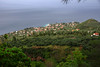

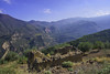
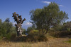

The above images may not be of the site on this page, but were taken nearby. They are loaded from Flickr so please click on them for image credits.
Click here to see more info for this site
Nearby sites
Click here to view sites on an interactive map of the areaKey: Red: member's photo, Blue: 3rd party photo, Yellow: other image, Green: no photo - please go there and take one, Grey: site destroyed
Download sites to:
KML (Google Earth)
GPX (GPS waypoints)
CSV (Garmin/Navman)
CSV (Excel)
To unlock full downloads you need to sign up as a Contributory Member. Otherwise downloads are limited to 50 sites.
Turn off the page maps and other distractions
Nearby sites listing. In the following links * = Image available
1.7km WSW 257° Fourni* Chambered Tomb
1.7km SW 215° Katholiko* Standing Stones
2.0km NNW 338° Tholos of Gaion* Ancient Temple
2.9km NNE 31° Pounta Diakopto Stones* Natural Stone / Erratic / Other Natural Feature
2.9km NNE 31° Pounta Diakopto* Standing Stone (Menhir)
3.1km SSW 206° Lofos Kernitsas* Natural Stone / Erratic / Other Natural Feature
11.0km NW 315° Helike Ancient Village or Settlement
38.2km W 263° Chalandritsa Ancient Village or Settlement
44.2km NNE 34° Delphi Temple* Ancient Temple
46.9km ESE 113° Sikyon Temple of Artemis* Ancient Temple
47.0km SE 137° Aidonia* Rock Cut Tomb
48.3km S 170° Orchomenos (Arcadia) Ancient Village or Settlement
48.7km WNW 302° Velvina Temple Ancient Temple
50.6km SE 132° Phlius* Ancient Village or Settlement
57.0km ESE 104° Heraion of Perachora* Ancient Temple
57.3km SE 131° Nemea* Ancient Village or Settlement
57.7km SE 131° Nemea stadium* Ancient Temple
63.8km ESE 115° Archaia Korinthos Museum* Museum
63.9km ENE 61° Lebadeia Temple of Zeus* Ancient Temple
63.9km ESE 115° Corinth Temple of Apollo* Ancient Temple
63.9km ESE 115° Archaia Korinthos* Ancient Village or Settlement
64.0km ESE 117° Akrokorinthos* Hillfort
64.6km ESE 112° Korakou* Ancient Village or Settlement
64.9km WNW 292° Calydon* Ancient Village or Settlement
65.1km WNW 292° Laphrion Sanctuary of Artemis Laphria and Apollo Laphrios Ancient Temple
View more nearby sites and additional images


 We would like to know more about this location. Please feel free to add a brief description and any relevant information in your own language.
 Wir möchten mehr über diese Stätte erfahren. Bitte zögern Sie nicht, eine kurze Beschreibung und relevante Informationen in Deutsch hinzuzufügen.
 Nous aimerions en savoir encore un peu sur les lieux. S'il vous plaît n'hesitez pas à ajouter une courte description et tous les renseignements pertinents dans votre propre langue.
 Quisieramos informarnos un poco más de las lugares. No dude en añadir una breve descripción y otros datos relevantes en su propio idioma.