<< Other Photo Pages >> Terkéï Massif Rock Art - Rock Art in Chad
Submitted by AlexHunger on Sunday, 15 February 2009 Page Views: 5146
Rock ArtSite Name: Terkéï Massif Rock Art Alternative Name: Ennedi Rock ArtCountry: Chad
NOTE: This site is 250.961 km away from the location you searched for.
Type: Rock Art
Nearest Town: Abeche
Latitude: 16.738412N Longitude: 21.702505E
Condition:
| 5 | Perfect |
| 4 | Almost Perfect |
| 3 | Reasonable but with some damage |
| 2 | Ruined but still recognisable as an ancient site |
| 1 | Pretty much destroyed, possibly visible as crop marks |
| 0 | No data. |
| -1 | Completely destroyed |
| 5 | Superb |
| 4 | Good |
| 3 | Ordinary |
| 2 | Not Good |
| 1 | Awful |
| 0 | No data. |
| 5 | Can be driven to, probably with disabled access |
| 4 | Short walk on a footpath |
| 3 | Requiring a bit more of a walk |
| 2 | A long walk |
| 1 | In the middle of nowhere, a nightmare to find |
| 0 | No data. |
| 5 | co-ordinates taken by GPS or official recorded co-ordinates |
| 4 | co-ordinates scaled from a detailed map |
| 3 | co-ordinates scaled from a bad map |
| 2 | co-ordinates of the nearest village |
| 1 | co-ordinates of the nearest town |
| 0 | no data |
Internal Links:
External Links:
I have visited· I would like to visit
DrewParsons would like to visit
")
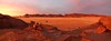
Prehistoric Rock art in cliffs of the Ennedi mountains in the eastern part of Chad, bordering Sudan.
You may be viewing yesterday's version of this page. To see the most up to date information please register for a free account.
Do not use the above information on other web sites or publications without permission of the contributor.
Nearby Images from Flickr


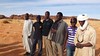
The above images may not be of the site on this page, but were taken nearby. They are loaded from Flickr so please click on them for image credits.
Click here to see more info for this site
Nearby sites
Click here to view sites on an interactive map of the areaKey: Red: member's photo, Blue: 3rd party photo, Yellow: other image, Green: no photo - please go there and take one, Grey: site destroyed
Download sites to:
KML (Google Earth)
GPX (GPS waypoints)
CSV (Garmin/Navman)
CSV (Excel)
To unlock full downloads you need to sign up as a Contributory Member. Otherwise downloads are limited to 50 sites.
Turn off the page maps and other distractions
Nearby sites listing. In the following links * = Image available
668.3km NNE 30° Jebel Uwenat Rock Art Rock Art
683.6km NNE 31° Karkur Talh Rock Art Rock Art
846.7km NNE 25° Cave of Swimmers Rock Art
846.7km NNE 25° Wadi Saura Cave Rock Art
861.4km NNE 29° Cave of the Beasts Rock Art
957.9km NW 313° African Rock Art Vandalised NOT SET
993.1km SE 125° Warina ancient settlement* Ancient Village or Settlement
996.6km SE 127° Dar Kabira Paintings* Rock Art
996.8km SE 127° Dar Kabira settlement* Ancient Village or Settlement
997.9km SE 125° Tareen basin and cup marks* Carving
997.9km ENE 64° Soleb* Ancient Temple
999.3km ENE 64° Sedeinga* Pyramid / Mastaba
1005.1km ENE 67° Sesebi* Ancient Village or Settlement
1028.1km E 82° Wadi Abu Dom Rock Art Rock Art
1079.4km E 79° Zuma Tumuli Round Barrow(s)
1081.2km ENE 79° El-Kurru Tumuli Round Barrow(s)
1081.5km ENE 79° El-Kurru Pyramids* Pyramid / Mastaba
1089.3km ENE 78° Sanam Temple Ancient Temple
1090.0km ENE 78° Gebel Barkal Temple B700 Ancient Temple
1090.0km ENE 78° Gebel Barkal Temple of Mut Ancient Temple
1090.7km ENE 78° Karima Pyramids* Pyramid / Mastaba
1091.4km ENE 78° Gebel Barkal Mountain and Rock Formation* Natural Stone / Erratic / Other Natural Feature
1091.5km ENE 78° Gebel Barkal Temple of Amon* Ancient Temple
1101.0km ENE 78° Nuri Pyramids* Pyramid / Mastaba
1142.0km NE 54° Nabta Playa* Stone Circle
View more nearby sites and additional images


 We would like to know more about this location. Please feel free to add a brief description and any relevant information in your own language.
 Wir möchten mehr über diese Stätte erfahren. Bitte zögern Sie nicht, eine kurze Beschreibung und relevante Informationen in Deutsch hinzuzufügen.
 Nous aimerions en savoir encore un peu sur les lieux. S'il vous plaît n'hesitez pas à ajouter une courte description et tous les renseignements pertinents dans votre propre langue.
 Quisieramos informarnos un poco más de las lugares. No dude en añadir una breve descripción y otros datos relevantes en su propio idioma.