<< Our Photo Pages >> Chindiei 2 Cave - Rock Art in Romania
Submitted by mfrincu on Tuesday, 18 August 2015 Page Views: 1564
Rock ArtSite Name: Chindiei 2 Cave Alternative Name: Chindiei 2 HoleCountry: Romania
NOTE: This site is 6.376 km away from the location you searched for.
Type: Rock Art
Nearest Town: Moldova Noua Nearest Village: Coronini
Latitude: 44.656111N Longitude: 21.730194E
Condition:
| 5 | Perfect |
| 4 | Almost Perfect |
| 3 | Reasonable but with some damage |
| 2 | Ruined but still recognisable as an ancient site |
| 1 | Pretty much destroyed, possibly visible as crop marks |
| 0 | No data. |
| -1 | Completely destroyed |
| 5 | Superb |
| 4 | Good |
| 3 | Ordinary |
| 2 | Not Good |
| 1 | Awful |
| 0 | No data. |
| 5 | Can be driven to, probably with disabled access |
| 4 | Short walk on a footpath |
| 3 | Requiring a bit more of a walk |
| 2 | A long walk |
| 1 | In the middle of nowhere, a nightmare to find |
| 0 | No data. |
| 5 | co-ordinates taken by GPS or official recorded co-ordinates |
| 4 | co-ordinates scaled from a detailed map |
| 3 | co-ordinates scaled from a bad map |
| 2 | co-ordinates of the nearest village |
| 1 | co-ordinates of the nearest town |
| 0 | no data |
Internal Links:
External Links:
I have visited· I would like to visit
mfrincu visited on 15th Aug 2015 - their rating: Cond: 3 Amb: 5 Access: 3 Not easy to find. Follow instructions on the site or ask a local about it. You will need good boots and long pants and sleeves to protect you from the bushes.
")
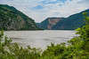
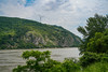
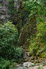
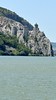
The cave is located about 80m above the Danube. It can be accessed by following a poorly maintained trail on steep terrain. There are two caves Chindiei 1 and Chindiei 2. Chindiei 1 can be seen from the road and is located right above Chindiei 2. The entrance to the cave used to be fortified and the remains of a locked door can be seen. The cave is a historical monument and is protected. It offers a splendid view of the Danube. The paintings, all of them in red color, can be found on the right hand side of the cave. While the cave is not deep it requires a flashlight for viewing the paintings. There is a lot of debate on the age of the drawings.
A total of 425 individual elements have been identified ranging from the VIII millennium B.C. to the medieval age. The oldest drawings depict human hands, birds and human characters while the newest represent crosses, pentagrams and Cyrillic writings. Some solar symbols are correlated with Dacian and proto-Dacian settlements.
To locate look drive 4km past Coronini eastwards towards the city of Orsova. On the left you will see a huge panel with Hungarian writings. Right after it (about 100m) look up and search for a huge cave. That is Chindiei 1 cave. Right under it, on the national road, look for a blue square on a power line pillar. The trail starts there and heads straight up to the cave.
You may be viewing yesterday's version of this page. To see the most up to date information please register for a free account.
")
")
")
Do not use the above information on other web sites or publications without permission of the contributor.
Nearby Images from Flickr
The above images may not be of the site on this page, but were taken nearby. They are loaded from Flickr so please click on them for image credits.
Click here to see more info for this site
Nearby sites
Click here to view sites on an interactive map of the areaKey: Red: member's photo, Blue: 3rd party photo, Yellow: other image, Green: no photo - please go there and take one, Grey: site destroyed
Download sites to:
KML (Google Earth)
GPX (GPS waypoints)
CSV (Garmin/Navman)
CSV (Excel)
To unlock full downloads you need to sign up as a Contributory Member. Otherwise downloads are limited to 50 sites.
Turn off the page maps and other distractions
Nearby sites listing. In the following links * = Image available
25.9km ESE 115° Lepenski Vir* Ancient Village or Settlement
40.5km WNW 282° Viminacium* Ancient Village or Settlement
43.0km SE 142° Rudna Glava Ancient Mine, Quarry or other Industry
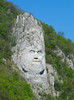
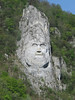
44.4km E 92° The face of Dacian King Decebalus* Sculptured Stone
46.0km E 90° Tabula Traiana* Carving
69.2km E 92° Schela Cladovei* Ancient Village or Settlement
74.2km E 92° Trajan's Roman Bridge* Ancient Trackway
82.9km SW 224° Grncarica Ancient Village or Settlement
88.3km W 278° Vinca Belo Brdo* Ancient Village or Settlement
91.6km SSE 157° Felix Romuliana* Ancient Palace
91.8km SSW 196° Zavičajni Muzej Paraćin* Museum
94.4km SSE 152° Zaječar museum* Museum
101.9km W 281° National Museum in Belgrade* Museum
118.2km NNW 336° Parta Neolithic Sanctuary* Ancient Temple
121.8km ENE 65° Priest's Cave* Rock Art
123.7km SSW 195° Narodni Muzej Kruševac* Museum
128.2km NNW 343° Timisoara Modern Stone Circle Modern Stone Circle etc
128.2km NNW 342° Museum of Banat Museum
131.2km SW 228° Mrcajevci Barrow Cemetery
147.0km NNW 345° Cornesti-Iarcuri Bronze Age Fortification Misc. Earthwork
149.3km S 175° Narodni muzej Niš* Museum
149.4km S 169° Balanica Cave Cave or Rock Shelter
150.6km NE 53° Banita Dacian citadel Hillfort
153.1km NE 46° Luncani-Piatra Rosie Dacian citadel* Hillfort
158.7km NE 44° Ardeu Dacian Hillfort* Hillfort
View more nearby sites and additional images


 We would like to know more about this location. Please feel free to add a brief description and any relevant information in your own language.
 Wir möchten mehr über diese Stätte erfahren. Bitte zögern Sie nicht, eine kurze Beschreibung und relevante Informationen in Deutsch hinzuzufügen.
 Nous aimerions en savoir encore un peu sur les lieux. S'il vous plaît n'hesitez pas à ajouter une courte description et tous les renseignements pertinents dans votre propre langue.
 Quisieramos informarnos un poco más de las lugares. No dude en añadir una breve descripción y otros datos relevantes en su propio idioma.