


<< Other Photo Pages >> Tsodilo Hills - Rock Art in Botswana
Submitted by KaiHofmann on Monday, 28 January 2013 Page Views: 3153
Rock ArtSite Name: Tsodilo HillsCountry: Botswana
NOTE: This site is 327.222 km away from the location you searched for.
Type: Rock Art
Nearest Village: Tsodilo Hills
Latitude: 18.758616S Longitude: 21.743422E
Condition:
| 5 | Perfect |
| 4 | Almost Perfect |
| 3 | Reasonable but with some damage |
| 2 | Ruined but still recognisable as an ancient site |
| 1 | Pretty much destroyed, possibly visible as crop marks |
| 0 | No data. |
| -1 | Completely destroyed |
| 5 | Superb |
| 4 | Good |
| 3 | Ordinary |
| 2 | Not Good |
| 1 | Awful |
| 0 | No data. |
| 5 | Can be driven to, probably with disabled access |
| 4 | Short walk on a footpath |
| 3 | Requiring a bit more of a walk |
| 2 | A long walk |
| 1 | In the middle of nowhere, a nightmare to find |
| 0 | No data. |
| 5 | co-ordinates taken by GPS or official recorded co-ordinates |
| 4 | co-ordinates scaled from a detailed map |
| 3 | co-ordinates scaled from a bad map |
| 2 | co-ordinates of the nearest village |
| 1 | co-ordinates of the nearest town |
| 0 | no data |
Be the first person to rate this site - see the 'Contribute!' box in the right hand menu.
Internal Links:
External Links:
")
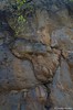
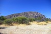
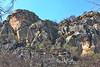
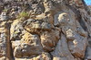
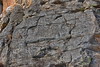
4500 rock paintings in the Tsodilo hills area. This site is protected by the UNESCO. They were painted by the San tribe in the last 24000 years. Most of the paintings were found at the Female Hill. The paintings show mostly animals. It is one of the most important San sanctuaries and painting sites in southern Africa.
You may be viewing yesterday's version of this page. To see the most up to date information please register for a free account.
")
")
Do not use the above information on other web sites or publications without permission of the contributor.
Nearby Images from Flickr
The above images may not be of the site on this page, but were taken nearby. They are loaded from Flickr so please click on them for image credits.
Click here to see more info for this site
Nearby sites
Click here to view sites on an interactive map of the areaKey: Red: member's photo, Blue: 3rd party photo, Yellow: other image, Green: no photo - please go there and take one, Grey: site destroyed
Download sites to:
KML (Google Earth)
GPX (GPS waypoints)
CSV (Garmin/Navman)
CSV (Excel)
To unlock full downloads you need to sign up as a Contributory Member. Otherwise downloads are limited to 50 sites.
Turn off the page maps and other distractions
Nearby sites listing. In the following links * = Image available
410.4km ESE 120° Makgadikgadi* Ancient Village or Settlement
533.7km ENE 65° Sikaunda petroglyphs Rock Art
640.0km WSW 238° Oropoko* Rock Art
683.4km WSW 253° Omburo Ost* Rock Art
685.2km WSW 254° Vingerklip* Natural Stone / Erratic / Other Natural Feature
688.5km WSW 240° Paula's Cave Rock Art
720.6km WSW 241° Phillipp's Cave Rock Art
724.2km ESE 107° Bambata Cave* Cave or Rock Shelter
734.9km ESE 106° World's View Matobo National Park* Natural Stone / Erratic / Other Natural Feature
735.8km ESE 107° Inanke Cave Cave or Rock Shelter
762.4km WSW 242° Bushman Paradise* Rock Art
767.1km SW 229° Rooisand Rock Painting* Rock Art
767.4km SE 145° Matsieng Footprints Rock Art
784.9km WSW 249° The White Lady Group* Rock Art
798.1km WSW 254° Twyfelfontein* Rock Art
798.1km WSW 254° Twyfelfontein* Stone Circle
836.3km NNE 27° Nyambwezu Rock Shelter Rock Art
843.6km SW 231° Mirabib* Natural Stone / Erratic / Other Natural Feature
876.4km ESE 118° Machete I Rock Art
877.3km SE 131° Palala River Bluffs San Rock Paintings* Rock Art
915.4km SSW 194° The Lost City of Kalahari* Ancient Village or Settlement
920.2km WNW 282° Pinturas Rupestres do Monte Negro Rock Art
945.7km NW 323° Moma Rock Art
967.6km WNW 301° Quilengues Gravures Rupestres Rock Art
977.8km ESE 101° Great Zimbabwe* Ancient Village or Settlement
View more nearby sites and additional images


 We would like to know more about this location. Please feel free to add a brief description and any relevant information in your own language.
 Wir möchten mehr über diese Stätte erfahren. Bitte zögern Sie nicht, eine kurze Beschreibung und relevante Informationen in Deutsch hinzuzufügen.
 Nous aimerions en savoir encore un peu sur les lieux. S'il vous plaît n'hesitez pas à ajouter une courte description et tous les renseignements pertinents dans votre propre langue.
 Quisieramos informarnos un poco más de las lugares. No dude en añadir una breve descripción y otros datos relevantes en su propio idioma.