<< Our Photo Pages >> Rambyno kalno akmuo - Marker Stone in Lithuania
Submitted by Alta-Falisa on Saturday, 26 September 2015 Page Views: 1366
Multi-periodSite Name: Rambyno kalno akmuo Alternative Name: Translation : Rambynas Mount's StoneCountry: Lithuania
NOTE: This site is 39.455 km away from the location you searched for.
Type: Marker Stone
Nearest Town: Tauragė Nearest Village: Bardinai
Latitude: 55.087500N Longitude: 22.021400E
Condition:
| 5 | Perfect |
| 4 | Almost Perfect |
| 3 | Reasonable but with some damage |
| 2 | Ruined but still recognisable as an ancient site |
| 1 | Pretty much destroyed, possibly visible as crop marks |
| 0 | No data. |
| -1 | Completely destroyed |
| 5 | Superb |
| 4 | Good |
| 3 | Ordinary |
| 2 | Not Good |
| 1 | Awful |
| 0 | No data. |
| 5 | Can be driven to, probably with disabled access |
| 4 | Short walk on a footpath |
| 3 | Requiring a bit more of a walk |
| 2 | A long walk |
| 1 | In the middle of nowhere, a nightmare to find |
| 0 | No data. |
| 5 | co-ordinates taken by GPS or official recorded co-ordinates |
| 4 | co-ordinates scaled from a detailed map |
| 3 | co-ordinates scaled from a bad map |
| 2 | co-ordinates of the nearest village |
| 1 | co-ordinates of the nearest town |
| 0 | no data |
Internal Links:
External Links:
")
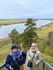
The stone erected at the very top of Rambynas Mount, here filed as (modern) marker stone, bears the incised Pillars of Gidiminias, an ubiquitous symbol of the reign of Gidiminias, born 1275, Grand-Duke of Lithuania from 1315 (or 1316) till his death in 1341.
The hill of Rambynas is all important to the Lithuanian nation -- and culture is not confined to ever fluctuating administrative borders.
Quoting Martynas Jankus (1858-1946) :
Rambynas will always be a holy place, as long as there is at least one Lithuanian in the world
should probably suffice to draw the attention on this site, more amply documented on these pages : Rambyno kalnas and Rambynas, among many others.
The site comprises a small ethnographic museum at (55.0867, 22.0329) and proposes several trails along the Nemunas (River Niemen), which marks the border with Kalinigrad Oblast (Russia).
Best accessed by road 4229, over a signposted T-junction at (55.09495, 22.02236).
You may be viewing yesterday's version of this page. To see the most up to date information please register for a free account.
")
")
")
")
Do not use the above information on other web sites or publications without permission of the contributor.
Nearby Images from Flickr

The above images may not be of the site on this page, but were taken nearby. They are loaded from Flickr so please click on them for image credits.
Click here to see more info for this site
Nearby sites
Click here to view sites on an interactive map of the areaKey: Red: member's photo, Blue: 3rd party photo, Yellow: other image, Green: no photo - please go there and take one, Grey: site destroyed
Download sites to:
KML (Google Earth)
GPX (GPS waypoints)
CSV (Garmin/Navman)
CSV (Excel)
To unlock full downloads you need to sign up as a Contributory Member. Otherwise downloads are limited to 50 sites.
Turn off the page maps and other distractions
Nearby sites listing. In the following links * = Image available
24.5km NE 42° Tauragė's 500th Anniversary Stone* Modern Stone Circle etc
62.4km NNE 17° Požerė akmuo* Natural Stone / Erratic / Other Natural Feature
62.7km NNE 18° Didžiųjų Vankių akmuo* Natural Stone / Erratic / Other Natural Feature
65.2km ESE 123° Lithuanian Millenium Stone* Modern Stone Circle etc
68.7km NE 42° Kriaučiaus akmuo* Natural Stone / Erratic / Other Natural Feature
74.6km N 7° Lopaičiai Dolmen* Burial Chamber or Dolmen
79.1km SE 129° Vilkaviškio krašto akmuo* Marker Stone
81.4km SSE 147° Vištyčio akmuo* Natural Stone / Erratic / Other Natural Feature
87.3km W 267° Curonian Spit Museum* Museum
92.4km WSW 243° Waldau Castle Museum* Museum
93.3km SSW 201° Grodzisko Bajory Wielkie Hillfort
99.7km W 262° Zelenogradsk Museum of Regional Studies* Museum
100.2km W 261° Kaup Barrows* Barrow Cemetery
101.0km SSE 160° Grodzisko Gulberek* Hillfort
102.6km NNW 332° Kretingos muziejus* Museum
104.7km WSW 247° Kaliningrad Regional Museum of History and Art* Museum
106.2km E 86° Karalgirio akmuo* Natural Stone / Erratic / Other Natural Feature
109.3km S 176° Borki Stone Circle (1)* Stone Circle
109.4km S 176° Borki Stone Cirlce (2)* Stone Circle
110.0km SSE 149° Grodzisko Szurpiły* Hillfort
110.4km NNE 12° Duobgirių akmuo* Natural Stone / Erratic / Other Natural Feature
110.8km S 176° Borki Cup-Marked Stone* Rock Art
111.2km NNE 12° Virmėnų akmuo* Modern Stone Circle etc
111.3km S 175° Borecka Forest Alignment* Stone Row / Alignment
111.6km SE 125° Padovinio piliakalnis* Artificial Mound
View more nearby sites and additional images


 We would like to know more about this location. Please feel free to add a brief description and any relevant information in your own language.
 Wir möchten mehr über diese Stätte erfahren. Bitte zögern Sie nicht, eine kurze Beschreibung und relevante Informationen in Deutsch hinzuzufügen.
 Nous aimerions en savoir encore un peu sur les lieux. S'il vous plaît n'hesitez pas à ajouter une courte description et tous les renseignements pertinents dans votre propre langue.
 Quisieramos informarnos un poco más de las lugares. No dude en añadir una breve descripción y otros datos relevantes en su propio idioma.