<< Our Photo Pages >> Waldau Castle Museum - Museum in Russia
Submitted by Ogneslav on Saturday, 02 July 2016 Page Views: 1355
MuseumsSite Name: Waldau Castle Museum Alternative Name: Музей Вальдавский замок.Country: Russia Type: Museum
Nearest Town: Kaliningrad Nearest Village: Nizovye
Latitude: 54.700580N Longitude: 20.742350E
Condition:
| 5 | Perfect |
| 4 | Almost Perfect |
| 3 | Reasonable but with some damage |
| 2 | Ruined but still recognisable as an ancient site |
| 1 | Pretty much destroyed, possibly visible as crop marks |
| 0 | No data. |
| -1 | Completely destroyed |
| 5 | Superb |
| 4 | Good |
| 3 | Ordinary |
| 2 | Not Good |
| 1 | Awful |
| 0 | No data. |
| 5 | Can be driven to, probably with disabled access |
| 4 | Short walk on a footpath |
| 3 | Requiring a bit more of a walk |
| 2 | A long walk |
| 1 | In the middle of nowhere, a nightmare to find |
| 0 | No data. |
| 5 | co-ordinates taken by GPS or official recorded co-ordinates |
| 4 | co-ordinates scaled from a detailed map |
| 3 | co-ordinates scaled from a bad map |
| 2 | co-ordinates of the nearest village |
| 1 | co-ordinates of the nearest town |
| 0 | no data |
Internal Links:
External Links:
")
Official Web Site: Музей Вальдавский замок
You may be viewing yesterday's version of this page. To see the most up to date information please register for a free account.
")
")
")
")
Do not use the above information on other web sites or publications without permission of the contributor.
Nearby Images from Flickr
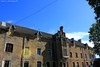
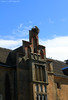
The above images may not be of the site on this page, but were taken nearby. They are loaded from Flickr so please click on them for image credits.
Click here to see more info for this site
Nearby sites
Click here to view sites on an interactive map of the areaKey: Red: member's photo, Blue: 3rd party photo, Yellow: other image, Green: no photo - please go there and take one, Grey: site destroyed
Download sites to:
KML (Google Earth)
GPX (GPS waypoints)
CSV (Garmin/Navman)
CSV (Excel)
To unlock full downloads you need to sign up as a Contributory Member. Otherwise downloads are limited to 50 sites.
Turn off the page maps and other distractions
Nearby sites listing. In the following links * = Image available
14.5km W 276° Kaliningrad Regional Museum of History and Art* Museum
31.0km NNW 326° Kaup Barrows* Barrow Cemetery
33.6km NNW 329° Zelenogradsk Museum of Regional Studies* Museum
37.6km N 351° Curonian Spit Museum* Museum
41.4km S 181° Grodzisko Bezledy Hillfort
43.2km NW 311° Rantawa Museum* Museum
43.6km NW 310° Pionersky* Hillfort
43.7km NW 309° The Lie Stone* Natural Stone / Erratic / Other Natural Feature
45.0km NW 306° Svetlogorsk* Hillfort
47.8km NW 304° Otradnoe* Barrow Cemetery
48.2km SSW 191° Grodzisko Wiewiórki Hillfort
52.5km S 179° Grodzisko Ardapy Promontory Fort / Cliff Castle
66.9km SE 131° Grodzisko Bajory Wielkie Hillfort
69.2km S 171° Bisztynek - Diabelski Kamień Natural Stone / Erratic / Other Natural Feature
69.9km SSW 196° Grodzisko Łaniewo Hillfort
72.1km S 189° Grodzisko Jarandowo Hillfort
73.0km SSE 154° Kurhan Tołkiny Round Barrow(s)
77.1km SW 229° Kurhany Piórkowo Barrow Cemetery
89.5km SSW 192° Grodzisko Kabikiejmy Górne Promontory Fort / Cliff Castle
92.4km ENE 62° Rambyno kalno akmuo* Marker Stone
111.6km SE 126° Borki Stone Circle (1)* Stone Circle
112.1km SE 126° Borki Stone Cirlce (2)* Stone Circle
113.3km SE 126° Borki Cup-Marked Stone* Rock Art
114.0km SE 126° Borecka Forest Alignment* Stone Row / Alignment
114.0km S 180° Kurhan Miłuki Round Barrow(s)
View more nearby sites and additional images


 We would like to know more about this location. Please feel free to add a brief description and any relevant information in your own language.
 Wir möchten mehr über diese Stätte erfahren. Bitte zögern Sie nicht, eine kurze Beschreibung und relevante Informationen in Deutsch hinzuzufügen.
 Nous aimerions en savoir encore un peu sur les lieux. S'il vous plaît n'hesitez pas à ajouter une courte description et tous les renseignements pertinents dans votre propre langue.
 Quisieramos informarnos un poco más de las lugares. No dude en añadir una breve descripción y otros datos relevantes en su propio idioma.