

<< Text Pages >> Dolmen de l'Oliva d'en David - Burial Chamber or Dolmen in France in Languedoc:Pyrénées-Orientales 66
Submitted by TheCaptain on Wednesday, 08 September 2010 Page Views: 2836
Neolithic and Bronze AgeSite Name: Dolmen de l'Oliva d'en DavidCountry: France
NOTE: This site is 5.819 km away from the location you searched for.
Département: Languedoc:Pyrénées-Orientales 66 Type: Burial Chamber or Dolmen
Nearest Town: Plaine du Roussillon Nearest Village: Salses
Latitude: 42.871705N Longitude: 2.947655E
Condition:
| 5 | Perfect |
| 4 | Almost Perfect |
| 3 | Reasonable but with some damage |
| 2 | Ruined but still recognisable as an ancient site |
| 1 | Pretty much destroyed, possibly visible as crop marks |
| 0 | No data. |
| -1 | Completely destroyed |
| 5 | Superb |
| 4 | Good |
| 3 | Ordinary |
| 2 | Not Good |
| 1 | Awful |
| 0 | No data. |
| 5 | Can be driven to, probably with disabled access |
| 4 | Short walk on a footpath |
| 3 | Requiring a bit more of a walk |
| 2 | A long walk |
| 1 | In the middle of nowhere, a nightmare to find |
| 0 | No data. |
| 5 | co-ordinates taken by GPS or official recorded co-ordinates |
| 4 | co-ordinates scaled from a detailed map |
| 3 | co-ordinates scaled from a bad map |
| 2 | co-ordinates of the nearest village |
| 1 | co-ordinates of the nearest town |
| 0 | no data |
Be the first person to rate this site - see the 'Contribute!' box in the right hand menu.
Internal Links:
External Links:
Dolmen de l'Oliva d'en David is a burial chamber in the community of Salses, Departement of Pyrénées-Orientales, Region of Languedoc-Roussillon
You may be viewing yesterday's version of this page. To see the most up to date information please register for a free account.
Do not use the above information on other web sites or publications without permission of the contributor.
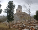
Nearby Images from Flickr
The above images may not be of the site on this page, but were taken nearby. They are loaded from Flickr so please click on them for image credits.
Click here to see more info for this site
Nearby sites
Click here to view sites on an interactive map of the areaKey: Red: member's photo, Blue: 3rd party photo, Yellow: other image, Green: no photo - please go there and take one, Grey: site destroyed
Download sites to:
KML (Google Earth)
GPX (GPS waypoints)
CSV (Garmin/Navman)
CSV (Excel)
To unlock full downloads you need to sign up as a Contributory Member. Otherwise downloads are limited to 50 sites.
Turn off the page maps and other distractions
Nearby sites listing. In the following links * = Image available
4.5km SW 228° Coma Francesca Cave or Rock Shelter
4.8km SSW 208° Combe Janicot Cave or Rock Shelter
4.8km SSW 209° Ossuaire du Portichol Cave or Rock Shelter
4.8km SSW 210° Coma Grillera Cave or Rock Shelter
4.9km SSW 209° Cova de l'Esperit Cave or Rock Shelter
7.3km W 261° Ossuaire du Roboul Cave or Rock Shelter
7.4km W 261° Grotte de Pla del Barrenc Cave or Rock Shelter
7.7km ENE 68° Grotte des Fées (Leucate) Cave or Rock Shelter
12.9km NNW 346° Dolmen de l'Aven Burial Chamber or Dolmen
13.0km WSW 253° Ossuaire des Gorges du Verdouble Cave or Rock Shelter
13.0km WSW 252° Grotte Noire Cave or Rock Shelter
13.0km WSW 253° Grotte St Martin Cave or Rock Shelter
13.1km N 2° Roquefort-des-Corbieres burial chamber Burial Chamber or Dolmen
13.1km WSW 252° Grotte de l'Amitie Cave or Rock Shelter
14.1km W 260° Grotte de Chataigniers Cave or Rock Shelter
16.1km WSW 257° La Caune de l'Arago* Cave or Rock Shelter
17.4km NW 322° Durban-Corbieres burial chamber Burial Chamber or Dolmen
17.8km WSW 249° Tautavel Musee de Prehistoire* Museum
17.9km SW 230° Cova de l'Amaga la Dona Cave or Rock Shelter
18.0km WSW 252° Puijols tumulus* Artificial Mound
18.1km S 181° Ruscino Oppidum* Ancient Village or Settlement
18.4km NNE 25° Grotte des Ramandils Cave or Rock Shelter
19.4km N 2° Oppidum de Pech de Maho* Ancient Village or Settlement
19.5km SSW 192° Pierre incrustée Standing Stone (Menhir)
20.1km SW 234° Grotte de Moli de Vent Cave or Rock Shelter
View more nearby sites and additional images


 We would like to know more about this location. Please feel free to add a brief description and any relevant information in your own language.
 Wir möchten mehr über diese Stätte erfahren. Bitte zögern Sie nicht, eine kurze Beschreibung und relevante Informationen in Deutsch hinzuzufügen.
 Nous aimerions en savoir encore un peu sur les lieux. S'il vous plaît n'hesitez pas à ajouter une courte description et tous les renseignements pertinents dans votre propre langue.
 Quisieramos informarnos un poco más de las lugares. No dude en añadir una breve descripción y otros datos relevantes en su propio idioma.