<< Text Pages >> Menhir d'Orcival - Standing Stone (Menhir) in France in Auvergne:Puy-de-Dôme (63)
Submitted by holger_rix on Wednesday, 22 June 2016 Page Views: 1309
Neolithic and Bronze AgeSite Name: Menhir d'OrcivalCountry: France
NOTE: This site is 4.99 km away from the location you searched for.
Département: Auvergne:Puy-de-Dôme (63) Type: Standing Stone (Menhir)
Nearest Town: Clermont-Ferrand Nearest Village: Orcival
Latitude: 45.682990N Longitude: 2.841600E
Condition:
| 5 | Perfect |
| 4 | Almost Perfect |
| 3 | Reasonable but with some damage |
| 2 | Ruined but still recognisable as an ancient site |
| 1 | Pretty much destroyed, possibly visible as crop marks |
| 0 | No data. |
| -1 | Completely destroyed |
| 5 | Superb |
| 4 | Good |
| 3 | Ordinary |
| 2 | Not Good |
| 1 | Awful |
| 0 | No data. |
| 5 | Can be driven to, probably with disabled access |
| 4 | Short walk on a footpath |
| 3 | Requiring a bit more of a walk |
| 2 | A long walk |
| 1 | In the middle of nowhere, a nightmare to find |
| 0 | No data. |
| 5 | co-ordinates taken by GPS or official recorded co-ordinates |
| 4 | co-ordinates scaled from a detailed map |
| 3 | co-ordinates scaled from a bad map |
| 2 | co-ordinates of the nearest village |
| 1 | co-ordinates of the nearest town |
| 0 | no data |
Be the first person to rate this site - see the 'Contribute!' box in the right hand menu.
Internal Links:
External Links:
Standing Stone (Menhir) in Auvergne:Puy-de-Dôme (63)
Orcival, Clermont-Ferrand, Puy-de-Dôme, Auvergne-Rhône-Alpes
Source: T4T35
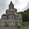
"A menhir is a pillar in the church. A miraculous spring once flowed into the bottom of the narthex which confirms the antiquity of the place Druidic."
You may be viewing yesterday's version of this page. To see the most up to date information please register for a free account.
Do not use the above information on other web sites or publications without permission of the contributor.
Nearby Images from Flickr


The above images may not be of the site on this page, but were taken nearby. They are loaded from Flickr so please click on them for image credits.
Click here to see more info for this site
Nearby sites
Click here to view sites on an interactive map of the areaKey: Red: member's photo, Blue: 3rd party photo, Yellow: other image, Green: no photo - please go there and take one, Grey: site destroyed
Download sites to:
KML (Google Earth)
GPX (GPS waypoints)
CSV (Garmin/Navman)
CSV (Excel)
To unlock full downloads you need to sign up as a Contributory Member. Otherwise downloads are limited to 50 sites.
Turn off the page maps and other distractions
Nearby sites listing. In the following links * = Image available
1.5km SW 227° Tombeau de la Sainte-Vierge Burial Chamber or Dolmen
7.8km NNW 329° Menhirs de Monges* Standing Stone (Menhir)
10.0km E 82° Grotte de Ribbe-Haute Cave or Rock Shelter
10.5km NNW 338° Menhir de Brigaudix* Standing Stone (Menhir)
10.6km NNW 342° Pierre Branlante de Gelles* Natural Stone / Erratic / Other Natural Feature
12.1km ESE 109° Pierre Longue (Fohet)* Standing Stone (Menhir)
12.7km SW 221° Murat-le-Quaire menhir Standing Stone (Menhir)
13.2km ENE 69° Menhir de Chatrat* Standing Stone (Menhir)
13.7km NE 44° Temple de Mercure* Ancient Temple
14.1km SE 132° Freydefond Menhir* Standing Stone (Menhir)
14.2km E 80° Menhir de Theix* Standing Stone (Menhir)
14.4km SE 143° Autel des Druides (Murol) Burial Chamber or Dolmen
14.5km SE 131° Dolmen de Pineyre* Burial Chamber or Dolmen
14.8km SW 235° Dolmen de Mejanesse Burial Chamber or Dolmen
14.8km SE 128° Plateau de Sailles tumulus* Barrow Cemetery
15.0km SE 132° Grottes de Châteauneuf* Cave or Rock Shelter
15.1km SE 135° Saint Roch Menhir* Standing Stone (Menhir)
15.3km ENE 67° Thedes Menhir* Standing Stone (Menhir)
15.5km SE 138° Dolmen de Sapchat 2* Burial Chamber or Dolmen
15.5km SE 138° Sapchat menhir* Standing Stone (Menhir)
15.5km SE 138° Dolmen de Sapchat* Burial Chamber or Dolmen
15.9km ESE 107° Cournols allée couverte* Passage Grave
15.9km ESE 109° Les Pierres Longues de Cournols* Natural Stone / Erratic / Other Natural Feature
15.9km ESE 109° Pierre Branlante de Cournols Natural Stone / Erratic / Other Natural Feature
16.0km ENE 77° Dolmen de Samson* Burial Chamber or Dolmen
View more nearby sites and additional images


 We would like to know more about this location. Please feel free to add a brief description and any relevant information in your own language.
 Wir möchten mehr über diese Stätte erfahren. Bitte zögern Sie nicht, eine kurze Beschreibung und relevante Informationen in Deutsch hinzuzufügen.
 Nous aimerions en savoir encore un peu sur les lieux. S'il vous plaît n'hesitez pas à ajouter une courte description et tous les renseignements pertinents dans votre propre langue.
 Quisieramos informarnos un poco más de las lugares. No dude en añadir una breve descripción y otros datos relevantes en su propio idioma.