


<< Our Photo Pages >> Tombeau de la Chrétienne - Pyramid / Mastaba in Algeria
Submitted by AlexHunger on Friday, 18 April 2008 Page Views: 10603
Multi-periodSite Name: Tombeau de la Chrétienne Alternative Name: la Cava Rumía, Tomb of king Juba II, Kubr-er-RumiaCountry: Algeria
NOTE: This site is 236.243 km away from the location you searched for.
Type: Pyramid / Mastaba
Nearest Town: Algiers Nearest Village: Sidi Rached
Latitude: 36.574457N Longitude: 2.552948E
Condition:
| 5 | Perfect |
| 4 | Almost Perfect |
| 3 | Reasonable but with some damage |
| 2 | Ruined but still recognisable as an ancient site |
| 1 | Pretty much destroyed, possibly visible as crop marks |
| 0 | No data. |
| -1 | Completely destroyed |
| 5 | Superb |
| 4 | Good |
| 3 | Ordinary |
| 2 | Not Good |
| 1 | Awful |
| 0 | No data. |
| 5 | Can be driven to, probably with disabled access |
| 4 | Short walk on a footpath |
| 3 | Requiring a bit more of a walk |
| 2 | A long walk |
| 1 | In the middle of nowhere, a nightmare to find |
| 0 | No data. |
| 5 | co-ordinates taken by GPS or official recorded co-ordinates |
| 4 | co-ordinates scaled from a detailed map |
| 3 | co-ordinates scaled from a bad map |
| 2 | co-ordinates of the nearest village |
| 1 | co-ordinates of the nearest town |
| 0 | no data |
Internal Links:
External Links:
I have visited· I would like to visit
SimonBlackmore visited on 21st Oct 2013 - their rating: Cond: 2 Amb: 5 Access: 5
SimonBlackmore have visited here
")
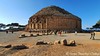
The tomb of the Mauretanian king Juba II and of his wife Cleopatra Selene (daughter of Marcus Antonius and Cleopatra, queen of Egypt). It is built on a hill 250 Meters above the sea. A circular stone building surmounted by a pyramid rests on a lower platform, 60 Meters square. Originally the monument was about 40 Meters in height, but it has been wantonly damaged. Its height is now about 30 Meters. It was ornamented with 60 engaged Ionic columns. The capitals of the columns have disappeared.
You may be viewing yesterday's version of this page. To see the most up to date information please register for a free account.
Do not use the above information on other web sites or publications without permission of the contributor.
Nearby Images from Flickr


The above images may not be of the site on this page, but were taken nearby. They are loaded from Flickr so please click on them for image credits.
Click here to see more info for this site
Nearby sites
Click here to view sites on an interactive map of the areaKey: Red: member's photo, Blue: 3rd party photo, Yellow: other image, Green: no photo - please go there and take one, Grey: site destroyed
Download sites to:
KML (Google Earth)
GPX (GPS waypoints)
CSV (Garmin/Navman)
CSV (Excel)
To unlock full downloads you need to sign up as a Contributory Member. Otherwise downloads are limited to 50 sites.
Turn off the page maps and other distractions
Nearby sites listing. In the following links * = Image available
10.1km WNW 282° Tefessedt* Ancient Village or Settlement
32.6km W 276° Iol.* Ancient Village or Settlement
48.6km ENE 65° Ikosim Ancient Village or Settlement
258.4km NNW 338° Ca Na Costa* Passage Grave
262.1km E 98° Dejmila* Ancient Village or Settlement
276.5km NNW 338° Sa Caleta Ancient Village or Settlement
277.0km NNW 339° Pou Roig* Holy Well or Sacred Spring
277.6km NNW 339° Puig Des Molins* Museum
280.1km NNW 337° Font den Xiquet* Holy Well or Sacred Spring
283.2km NNW 338° Font de Verger* Holy Well or Sacred Spring
286.8km NNW 343° Font de Peralta* Holy Well or Sacred Spring
288.5km NNW 339° Pou de Forada* Holy Well or Sacred Spring
289.0km NNW 341° Font de Balafi* Holy Well or Sacred Spring
289.7km NNW 341° Pou d’Albarqueta Holy Well or Sacred Spring
291.7km NNW 343° Cova d'Es Cuieram Cave or Rock Shelter
292.4km NNW 342° Pou de Labritja* Holy Well or Sacred Spring
293.4km NNW 342° Pou des Baladre* Holy Well or Sacred Spring
294.2km NNW 341° Font des ses Torres Holy Well or Sacred Spring
307.3km N 9° Punta des Baus* Ancient Village or Settlement
309.6km N 8° Ets Antigors* Ancient Village or Settlement
312.1km N 5° Talaies de Cala Pi* Ancient Village or Settlement
313.6km N 6° Talaiot de Ca n'Estela* Broch or Nuraghe
314.8km N 4° Capocorb Vell* Ancient Village or Settlement
315.8km N 9° Talaies de Can Jordi* Ancient Village or Settlement
318.5km N 8° Es Rossells I.* Ancient Village or Settlement
View more nearby sites and additional images


 We would like to know more about this location. Please feel free to add a brief description and any relevant information in your own language.
 Wir möchten mehr über diese Stätte erfahren. Bitte zögern Sie nicht, eine kurze Beschreibung und relevante Informationen in Deutsch hinzuzufügen.
 Nous aimerions en savoir encore un peu sur les lieux. S'il vous plaît n'hesitez pas à ajouter une courte description et tous les renseignements pertinents dans votre propre langue.
 Quisieramos informarnos un poco más de las lugares. No dude en añadir una breve descripción y otros datos relevantes en su propio idioma.