<< Our Photo Pages >> Aquaduc de Saint Polycarpe - Ancient Mine, Quarry or other Industry in France in Midi:Ariège (09)
Submitted by regina on Tuesday, 29 December 2020 Page Views: 445
Multi-periodSite Name: Aquaduc de Saint PolycarpeCountry: France
NOTE: This site is 8.35 km away from the location you searched for.
Département: Midi:Ariège (09) Type: Ancient Mine, Quarry or other Industry
Nearest Town: Limoux Nearest Village: Saint Polycarpe
Latitude: 43.040300N Longitude: 2.290500E
Condition:
| 5 | Perfect |
| 4 | Almost Perfect |
| 3 | Reasonable but with some damage |
| 2 | Ruined but still recognisable as an ancient site |
| 1 | Pretty much destroyed, possibly visible as crop marks |
| 0 | No data. |
| -1 | Completely destroyed |
| 5 | Superb |
| 4 | Good |
| 3 | Ordinary |
| 2 | Not Good |
| 1 | Awful |
| 0 | No data. |
| 5 | Can be driven to, probably with disabled access |
| 4 | Short walk on a footpath |
| 3 | Requiring a bit more of a walk |
| 2 | A long walk |
| 1 | In the middle of nowhere, a nightmare to find |
| 0 | No data. |
| 5 | co-ordinates taken by GPS or official recorded co-ordinates |
| 4 | co-ordinates scaled from a detailed map |
| 3 | co-ordinates scaled from a bad map |
| 2 | co-ordinates of the nearest village |
| 1 | co-ordinates of the nearest town |
| 0 | no data |
Internal Links:
External Links:
I have visited· I would like to visit
cornerstone would like to visit
")
The aqueduct intercepted the water from the Saint-Polycarpe river and transported it to a large stone basin, where the monks did their laundry and the water thus recovered was also used to water the gardens.
You may be viewing yesterday's version of this page. To see the most up to date information please register for a free account.
")
")
")
")
Do not use the above information on other web sites or publications without permission of the contributor.
Nearby Images from Flickr
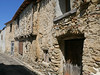
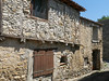
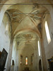

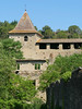

The above images may not be of the site on this page, but were taken nearby. They are loaded from Flickr so please click on them for image credits.
Click here to see more info for this site
Nearby sites
Click here to view sites on an interactive map of the areaKey: Red: member's photo, Blue: 3rd party photo, Yellow: other image, Green: no photo - please go there and take one, Grey: site destroyed
Download sites to:
KML (Google Earth)
GPX (GPS waypoints)
CSV (Garmin/Navman)
CSV (Excel)
To unlock full downloads you need to sign up as a Contributory Member. Otherwise downloads are limited to 50 sites.
Turn off the page maps and other distractions
Nearby sites listing. In the following links * = Image available
3.0km S 187° Saint-Salvayre Menhir* Standing Stone (Menhir)
11.0km SSE 156° La Pierre Droite (Peyrolles)* Standing Stone (Menhir)
13.8km SE 127° Dolmen du Clot de l'Oste Burial Chamber or Dolmen
14.2km S 171° Le Cercle de Rennes-les-Bains Stone Circle
14.6km S 172° Les Pierres Tremblantes (Rennes-les-Bains)* Natural Stone / Erratic / Other Natural Feature
15.7km S 178° Wall near Rennes-le-Chateau* Natural Stone / Erratic / Other Natural Feature
17.8km ESE 110° Salza 3 burial chamber Burial Chamber or Dolmen
17.9km ESE 111° Salza 1 burial chamber Burial Chamber or Dolmen
17.9km ESE 110° Salza 4 burial chamber Burial Chamber or Dolmen
18.0km ESE 111° Salza 2 burial chamber Burial Chamber or Dolmen
18.6km NE 43° Dolmen de la Madeleine d’Albesse* Burial Chamber or Dolmen
19.4km NNE 18° Carcassonne - La Cité* Ancient Village or Settlement
20.5km ENE 76° Menhir de la Pierre Droite (Rieux-en-Val)* Standing Stone (Menhir)
21.1km ESE 115° Mouthoumet burial chamber Burial Chamber or Dolmen
21.5km NE 47° Les Bénitiers Rock Outcrop
22.8km N 6° Pennautier burial chamber Burial Chamber or Dolmen
22.8km NNE 27° Dolmen de Perrières Burial Chamber or Dolmen
23.2km ESE 105° Roc de Fenne Prenz* Cave or Rock Shelter
23.3km SSE 150° Camps-sur-Agly burial chamber Burial Chamber or Dolmen
23.3km SE 144° Dolmen du Col-de-Guilhem* Burial Chamber or Dolmen
23.4km NE 42° Le Mourral Millegrand* Hillfort
23.8km ESE 105° Moulintour menhir* Standing Stone (Menhir)
24.2km SE 145° Cubières-sur-Cinoble 2 burial chamber Burial Chamber or Dolmen
24.3km SE 145° Cubières-sur-Cinoble 3 burial chamber Burial Chamber or Dolmen
24.3km SE 145° Cubières-sur-Cinoble 4 burial chamber Burial Chamber or Dolmen
View more nearby sites and additional images


 We would like to know more about this location. Please feel free to add a brief description and any relevant information in your own language.
 Wir möchten mehr über diese Stätte erfahren. Bitte zögern Sie nicht, eine kurze Beschreibung und relevante Informationen in Deutsch hinzuzufügen.
 Nous aimerions en savoir encore un peu sur les lieux. S'il vous plaît n'hesitez pas à ajouter une courte description et tous les renseignements pertinents dans votre propre langue.
 Quisieramos informarnos un poco más de las lugares. No dude en añadir una breve descripción y otros datos relevantes en su propio idioma.