<< Our Photo Pages >> Smoleń - Zamek Pilcza - Ancient Village or Settlement in Poland in Slaskie
Submitted by SolarMegalith on Thursday, 11 June 2020 Page Views: 721
Multi-periodSite Name: Smoleń - Zamek Pilcza Alternative Name: Pilcza CastleCountry: Poland
NOTE: This site is 4.004 km away from the location you searched for.
Voivodeship: Slaskie Type: Ancient Village or Settlement
Nearest Town: Pilica Nearest Village: Smoleń
Latitude: 50.438424N Longitude: 19.675009E
Condition:
| 5 | Perfect |
| 4 | Almost Perfect |
| 3 | Reasonable but with some damage |
| 2 | Ruined but still recognisable as an ancient site |
| 1 | Pretty much destroyed, possibly visible as crop marks |
| 0 | No data. |
| -1 | Completely destroyed |
| 5 | Superb |
| 4 | Good |
| 3 | Ordinary |
| 2 | Not Good |
| 1 | Awful |
| 0 | No data. |
| 5 | Can be driven to, probably with disabled access |
| 4 | Short walk on a footpath |
| 3 | Requiring a bit more of a walk |
| 2 | A long walk |
| 1 | In the middle of nowhere, a nightmare to find |
| 0 | No data. |
| 5 | co-ordinates taken by GPS or official recorded co-ordinates |
| 4 | co-ordinates scaled from a detailed map |
| 3 | co-ordinates scaled from a bad map |
| 2 | co-ordinates of the nearest village |
| 1 | co-ordinates of the nearest town |
| 0 | no data |
Internal Links:
External Links:
I have visited· I would like to visit
SolarMegalith visited on 6th Jun 2020 - their rating: Cond: 1 Amb: 4 Access: 4
")
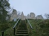
A rocky hill near the village of Smoleń is occupied by ruins of the 14th century castle consisting of an inner ward with a circular tower located on a rocky summit and two outer wards (western and eastern) below it. The site was inhabited in prehistoric times - pottery sherds of Lusatian culture (Late Bronze Age/Early Iron Age) and Przeworsk culture (3rd century BC - 5th century AD) were found here.
You may be viewing yesterday's version of this page. To see the most up to date information please register for a free account.
")
")
")
Do not use the above information on other web sites or publications without permission of the contributor.
Nearby Images from Flickr
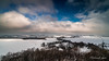
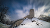
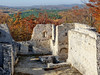
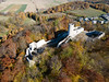

The above images may not be of the site on this page, but were taken nearby. They are loaded from Flickr so please click on them for image credits.
Click here to see more info for this site
Nearby sites
Click here to view sites on an interactive map of the areaKey: Red: member's photo, Blue: 3rd party photo, Yellow: other image, Green: no photo - please go there and take one, Grey: site destroyed
Download sites to:
KML (Google Earth)
GPX (GPS waypoints)
CSV (Garmin/Navman)
CSV (Excel)
To unlock full downloads you need to sign up as a Contributory Member. Otherwise downloads are limited to 50 sites.
Turn off the page maps and other distractions
Nearby sites listing. In the following links * = Image available
1.5km SSW 206° Jaskinia Na Biśniku Cave or Rock Shelter
6.6km E 84° Grodzisko Udórz Hillfort
15.7km NW 320° Jaskinia w Dziadowej Skale Cave or Rock Shelter
18.5km NNW 337° Grodzisko Góra Słupsko* Hillfort
19.9km SSW 212° Grodzisko Stary Olkusz* Hillfort
30.0km S 171° Grodzisko Będkowice* Hillfort
30.8km SSE 162° Jaskinia Wierzchowska Górna* Cave or Rock Shelter
31.1km SSE 162° Jaskinia Mamutowa* Cave or Rock Shelter
32.6km S 186° Grodzisko Bartlowa Góra - Czatkowice Hillfort
33.5km NNW 327° Grodzisko Wały - Potok Złoty* Hillfort
42.2km NW 321° Jaskinia Komarowa Cave or Rock Shelter
42.6km S 176° Grodzisko Mników Hillfort
46.2km SSE 156° Archaeological Museum of Kraków* Museum
46.3km NW 322° Jaskinia Towarna Cave or Rock Shelter
46.6km SSE 157° Kraków - Wawel* Ancient Village or Settlement
47.8km ESE 102° Kurhan Szczotkowice Round Barrow(s)
48.0km ESE 108° Kurhan Pałecznica Round Barrow(s)
48.9km SSE 156° Kopiec Krakusa* Artificial Mound
49.6km SE 146° Kopiec Wandy* Artificial Mound
49.9km S 177° Wołowice Flint Mine Ancient Mine, Quarry or other Industry
52.9km NW 325° Grodzisko Gąszczyk* Hillfort
56.7km NW 322° Wyczerpy Górne Bronze Age Settlement Ancient Village or Settlement
65.0km S 181° Grodzisko Bugaj* Hillfort
65.3km SE 146° Kurhany Jawczyce Barrow Cemetery
66.3km S 190° Grodzisko Gorzeń Górny* Hillfort
View more nearby sites and additional images


 We would like to know more about this location. Please feel free to add a brief description and any relevant information in your own language.
 Wir möchten mehr über diese Stätte erfahren. Bitte zögern Sie nicht, eine kurze Beschreibung und relevante Informationen in Deutsch hinzuzufügen.
 Nous aimerions en savoir encore un peu sur les lieux. S'il vous plaît n'hesitez pas à ajouter une courte description et tous les renseignements pertinents dans votre propre langue.
 Quisieramos informarnos un poco más de las lugares. No dude en añadir una breve descripción y otros datos relevantes en su propio idioma.