<< Our Photo Pages >> Muzeum Miejskie Suchej Beskidzkiej - Museum in Poland in Malopolskie
Submitted by SolarMegalith on Tuesday, 30 October 2018 Page Views: 856
MuseumsSite Name: Muzeum Miejskie Suchej Beskidzkiej Alternative Name: Municipal Museum of Sucha BeskidzkaCountry: Poland Voivodeship: Malopolskie Type: Museum
Nearest Town: Sucha Beskidzka
Latitude: 49.746170N Longitude: 19.601584E
Condition:
| 5 | Perfect |
| 4 | Almost Perfect |
| 3 | Reasonable but with some damage |
| 2 | Ruined but still recognisable as an ancient site |
| 1 | Pretty much destroyed, possibly visible as crop marks |
| 0 | No data. |
| -1 | Completely destroyed |
| 5 | Superb |
| 4 | Good |
| 3 | Ordinary |
| 2 | Not Good |
| 1 | Awful |
| 0 | No data. |
| 5 | Can be driven to, probably with disabled access |
| 4 | Short walk on a footpath |
| 3 | Requiring a bit more of a walk |
| 2 | A long walk |
| 1 | In the middle of nowhere, a nightmare to find |
| 0 | No data. |
| 5 | co-ordinates taken by GPS or official recorded co-ordinates |
| 4 | co-ordinates scaled from a detailed map |
| 3 | co-ordinates scaled from a bad map |
| 2 | co-ordinates of the nearest village |
| 1 | co-ordinates of the nearest town |
| 0 | no data |
Internal Links:
External Links:
I have visited· I would like to visit
SolarMegalith visited on 16th Oct 2018 - their rating: Cond: 5 Amb: 5 Access: 5
")
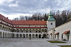
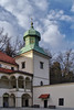
The Municipal Museum of Sucha Beskidzka is located in a 16th century Renessaince castle which was extended in the 17th and 18th century. The groundfloor hosts an archaeological exhibition which includes finds from the valley of Skawa river, ranging from Palaeolithic to medieval periods. Of particular significance is the Early Iron Age hoard of the Lusatian culture from Zagórze (site 8.).
The Museum is open in following hours:
May-September: Tuesday-Saturday 8am-4pm, Sunday 9am-5pm
October-April: Tuesday-Sunday 8am-4pm, Sunday and Monday closed
Museum Website
You may be viewing yesterday's version of this page. To see the most up to date information please register for a free account.
")
")
")
")
Do not use the above information on other web sites or publications without permission of the contributor.
Nearby Images from Flickr


The above images may not be of the site on this page, but were taken nearby. They are loaded from Flickr so please click on them for image credits.
Click here to see more info for this site
Nearby sites
Click here to view sites on an interactive map of the areaKey: Red: member's photo, Blue: 3rd party photo, Yellow: other image, Green: no photo - please go there and take one, Grey: site destroyed
Download sites to:
KML (Google Earth)
GPX (GPS waypoints)
CSV (Garmin/Navman)
CSV (Excel)
To unlock full downloads you need to sign up as a Contributory Member. Otherwise downloads are limited to 50 sites.
Turn off the page maps and other distractions
Nearby sites listing. In the following links * = Image available
2.8km NNW 344° Grodzisko Zembrzyce* Promontory Fort / Cliff Castle
12.6km NNE 18° Grodzisko Bugaj* Hillfort
13.6km NNW 330° Grodzisko Gorzeń Górny* Hillfort
19.3km WSW 254° Grodzisko Gilowice* Hillfort
28.4km NNE 17° Wołowice Flint Mine Ancient Mine, Quarry or other Industry
35.5km NNE 14° Grodzisko Mników Hillfort
39.9km ENE 78° Grodzisko Poznachowice Górne* Hillfort
40.7km E 79° Grodzisko Klasztorzysko* Hillfort
41.3km NE 38° Kopiec Krakusa* Artificial Mound
41.7km NE 35° Kraków - Wawel* Ancient Village or Settlement
42.1km NE 35° Archaeological Museum of Kraków* Museum
42.6km WNW 282° Grodzisko Stare Bielsko* Hillfort
44.6km N 3° Grodzisko Bartlowa Góra - Czatkowice Hillfort
46.1km W 275° Palenica Earthwork* Misc. Earthwork
46.8km W 276° Grodzisko Zómczysko* Ancient Village or Settlement
47.5km ENE 61° Kurhany Jawczyce Barrow Cemetery
48.1km W 278° Młyńska Kępa Settlement* Ancient Village or Settlement
48.4km NNE 12° Grodzisko Będkowice* Hillfort
49.1km NE 43° Kopiec Wandy* Artificial Mound
49.5km NNE 17° Jaskinia Mamutowa* Cave or Rock Shelter
49.8km NNE 17° Jaskinia Wierzchowska Górna* Cave or Rock Shelter
52.6km ENE 62° Kurhan Krakuszowice Round Barrow(s)
59.7km W 275° Grodzisko Międzyświeć* Hillfort
60.3km N 355° Grodzisko Stary Olkusz* Hillfort
60.6km ENE 65° Grodzisko Łapczyca Hillfort
View more nearby sites and additional images


 We would like to know more about this location. Please feel free to add a brief description and any relevant information in your own language.
 Wir möchten mehr über diese Stätte erfahren. Bitte zögern Sie nicht, eine kurze Beschreibung und relevante Informationen in Deutsch hinzuzufügen.
 Nous aimerions en savoir encore un peu sur les lieux. S'il vous plaît n'hesitez pas à ajouter une courte description et tous les renseignements pertinents dans votre propre langue.
 Quisieramos informarnos un poco más de las lugares. No dude en añadir una breve descripción y otros datos relevantes en su propio idioma.