<< Text Pages >> Apollonia (Albania) - Ancient Village or Settlement in North Macedonia
Submitted by AlexHunger on Friday, 22 December 2006 Page Views: 6575
Multi-periodSite Name: Apollonia (Albania)Country: North Macedonia
NOTE: This site is 9.985 km away from the location you searched for.
Type: Ancient Village or Settlement
Nearest Town: Vlorë Nearest Village: Shtyllas
Latitude: 40.720900N Longitude: 19.471230E
Condition:
| 5 | Perfect |
| 4 | Almost Perfect |
| 3 | Reasonable but with some damage |
| 2 | Ruined but still recognisable as an ancient site |
| 1 | Pretty much destroyed, possibly visible as crop marks |
| 0 | No data. |
| -1 | Completely destroyed |
| 5 | Superb |
| 4 | Good |
| 3 | Ordinary |
| 2 | Not Good |
| 1 | Awful |
| 0 | No data. |
| 5 | Can be driven to, probably with disabled access |
| 4 | Short walk on a footpath |
| 3 | Requiring a bit more of a walk |
| 2 | A long walk |
| 1 | In the middle of nowhere, a nightmare to find |
| 0 | No data. |
| 5 | co-ordinates taken by GPS or official recorded co-ordinates |
| 4 | co-ordinates scaled from a detailed map |
| 3 | co-ordinates scaled from a bad map |
| 2 | co-ordinates of the nearest village |
| 1 | co-ordinates of the nearest town |
| 0 | no data |
Internal Links:
External Links:
Ancient Village or Settlement in Albania
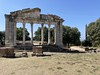
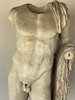
Illyrian town from 6th Century BCE, later conquered by the Greeks and then the Romans. There are remains of temples and a stadium.
The Doric temple measured 40 Meters by 23 Meters and had 11 by 6 Columns dating 500 BCE. One column of the temple survives.
40° 43,254N
19° 28,274E
You may be viewing yesterday's version of this page. To see the most up to date information please register for a free account.
Do not use the above information on other web sites or publications without permission of the contributor.
Nearby Images from Flickr

The above images may not be of the site on this page, but were taken nearby. They are loaded from Flickr so please click on them for image credits.
Click here to see more info for this site
Nearby sites
Click here to view sites on an interactive map of the areaKey: Red: member's photo, Blue: 3rd party photo, Yellow: other image, Green: no photo - please go there and take one, Grey: site destroyed
Download sites to:
KML (Google Earth)
GPX (GPS waypoints)
CSV (Garmin/Navman)
CSV (Excel)
To unlock full downloads you need to sign up as a Contributory Member. Otherwise downloads are limited to 50 sites.
Turn off the page maps and other distractions
Nearby sites listing. In the following links * = Image available
22.7km ESE 111° Lofkënd Tumulus Round Barrow(s)
30.1km SE 132° Byllis Ancient Village or Settlement
32.4km SE 132° Nikaia Ancient Village or Settlement
42.6km SSE 153° Amantia Hillfort
45.2km S 180° Oricum Ancient Village or Settlement
65.8km N 358° Epidamnos Ancient Temple
107.0km E 92° Vashtëmi* Ancient Village or Settlement
107.7km E 100° Kamenicë Tumulus Round Barrow(s)
109.5km WSW 243° Gurgulante Dolmen* Burial Chamber or Dolmen
109.9km SW 233° Fausa Standing Stone* Standing Stone (Menhir)
110.0km SW 233° Madonna del Rosario Menhir* Standing Stone (Menhir)
110.2km SW 235° Palanzano Standing stone* Standing Stone (Menhir)
110.4km SW 233° Madonna di Costantinopoli Standing stone* Standing Stone (Menhir)
110.4km SW 233° Vico Nuovo Menhirs* Standing Stones
110.5km SW 233° San Vincenzo Standing stone* Standing Stone (Menhir)
110.7km SW 233° San Paolo Standing stone* Standing Stone (Menhir)
110.8km SW 233° Vicinanze I Standing stone* Standing Stone (Menhir)
110.9km WSW 243° Placa Dolmen* Burial Chamber or Dolmen
110.9km WSW 239° Staurotomea Standing stone* Standing Stone (Menhir)
111.0km SW 234° Vicinanze II Standing stone* Standing Stone (Menhir)
111.0km SW 233° Peschio Dolmen* Burial Chamber or Dolmen
111.1km WSW 239° Chianca di Santo Stefano Trilithon* Burial Chamber or Dolmen
111.2km SW 236° Santu Lasi Standing stone Standing Stone (Menhir)
111.2km SW 233° Orfine Dolmen* Burial Chamber or Dolmen
111.4km SW 233° Chiancuse Dolmen* Burial Chamber or Dolmen
View more nearby sites and additional images


 We would like to know more about this location. Please feel free to add a brief description and any relevant information in your own language.
 Wir möchten mehr über diese Stätte erfahren. Bitte zögern Sie nicht, eine kurze Beschreibung und relevante Informationen in Deutsch hinzuzufügen.
 Nous aimerions en savoir encore un peu sur les lieux. S'il vous plaît n'hesitez pas à ajouter une courte description et tous les renseignements pertinents dans votre propre langue.
 Quisieramos informarnos un poco más de las lugares. No dude en añadir una breve descripción y otros datos relevantes en su propio idioma.