


<< Our Photo Pages >> Diepkloof - Rock Outcrop in South Africa
Submitted by bat400 on Friday, 05 March 2010 Page Views: 7224
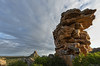
Natural PlacesSite Name: DiepkloofCountry: South Africa Type: Rock Outcrop
Nearest Town: Capetown, South Africa Nearest Village: Elands Bay
Latitude: 32.38685S Longitude: 18.453055E
Condition:
| 5 | Perfect |
| 4 | Almost Perfect |
| 3 | Reasonable but with some damage |
| 2 | Ruined but still recognisable as an ancient site |
| 1 | Pretty much destroyed, possibly visible as crop marks |
| 0 | No data. |
| -1 | Completely destroyed |
| 5 | Superb |
| 4 | Good |
| 3 | Ordinary |
| 2 | Not Good |
| 1 | Awful |
| 0 | No data. |
| 5 | Can be driven to, probably with disabled access |
| 4 | Short walk on a footpath |
| 3 | Requiring a bit more of a walk |
| 2 | A long walk |
| 1 | In the middle of nowhere, a nightmare to find |
| 0 | No data. |
| 5 | co-ordinates taken by GPS or official recorded co-ordinates |
| 4 | co-ordinates scaled from a detailed map |
| 3 | co-ordinates scaled from a bad map |
| 2 | co-ordinates of the nearest village |
| 1 | co-ordinates of the nearest town |
| 0 | no data |
Be the first person to rate this site - see the 'Contribute!' box in the right hand menu.
Internal Links:
External Links:
I have visited· I would like to visit
bat400 would like to visit
")
Note: Engraved Ostrich Eggs Suggest Early Early Man's Symbolic Thought. See comment.
You may be viewing yesterday's version of this page. To see the most up to date information please register for a free account.
Do not use the above information on other web sites or publications without permission of the contributor.
Nearby Images from Flickr
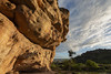
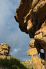
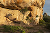
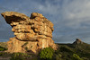

The above images may not be of the site on this page, but were taken nearby. They are loaded from Flickr so please click on them for image credits.
Click here to see more info for this site
Nearby sites
Click here to view sites on an interactive map of the areaKey: Red: member's photo, Blue: 3rd party photo, Yellow: other image, Green: no photo - please go there and take one, Grey: site destroyed
Download sites to:
KML (Google Earth)
GPX (GPS waypoints)
CSV (Garmin/Navman)
CSV (Excel)
To unlock full downloads you need to sign up as a Contributory Member. Otherwise downloads are limited to 50 sites.
Turn off the page maps and other distractions
Nearby sites listing. In the following links * = Image available
171.5km S 181° Iziko South African Museum Museum
341.6km SE 132° Blombos Cave* Cave or Rock Shelter
393.9km ESE 122° Pinnacle Point* Cave or Rock Shelter
413.5km NNW 341° Spitzkloof* Cave or Rock Shelter
535.6km NNW 346° Apollo 11 Cave* Cave or Rock Shelter
583.9km ESE 111° Klasies River Caves* Cave or Rock Shelter
637.1km N 10° The Lost City of Kalahari* Ancient Village or Settlement
650.2km ENE 61° Thomas' Farm Belmont Rock Art Rock Art
672.9km ENE 57° Driekopseiland Rock Art Rock Art
683.5km NE 42° Kathu Pan* Ancient Mine, Quarry or other Industry
703.9km NE 45° Wonderwerk Cave* Cave or Rock Shelter
723.3km ENE 57° Wildebeestkuil* Rock Art
724.5km NE 56° Nooitgedacht Rock art Rock Art
728.1km ENE 58° McGregor Museum Museum
817.2km NE 54° Stowlands Rock art Rock Art
926.6km NE 53° Wolmaransstad Rock Art Rock Art
973.4km ENE 76° Lesob 1 Rock Art
974.0km ENE 76° Lesob 2 Rock Art
974.1km ENE 76° Lesob 3 Rock Art
974.5km ENE 75° Lesob 5 Rock Art
974.5km ENE 76° Lesob 4 Rock Art
1038.8km NNW 342° Mirabib* Natural Stone / Erratic / Other Natural Feature
1051.2km NNW 347° Rooisand Rock Painting* Rock Art
1093.2km ENE 77° Ikanti Shelter I Rock Art
1119.8km ENE 76° Kamberg rock art Rock Art
View more nearby sites and additional images


 We would like to know more about this location. Please feel free to add a brief description and any relevant information in your own language.
 Wir möchten mehr über diese Stätte erfahren. Bitte zögern Sie nicht, eine kurze Beschreibung und relevante Informationen in Deutsch hinzuzufügen.
 Nous aimerions en savoir encore un peu sur les lieux. S'il vous plaît n'hesitez pas à ajouter une courte description et tous les renseignements pertinents dans votre propre langue.
 Quisieramos informarnos un poco más de las lugares. No dude en añadir una breve descripción y otros datos relevantes en su propio idioma.