<< Our Photo Pages >> Moeraki Beach Boulders (Otago) - Natural Stone / Erratic / Other Natural Feature in New Zealand
Submitted by Anne T on Monday, 04 February 2019 Page Views: 4157
Natural PlacesSite Name: Moeraki Beach Boulders (Otago)Country: New Zealand
NOTE: This site is 1518.288 km away from the location you searched for.
Type: Natural Stone / Erratic / Other Natural Feature
Nearest Town: Hampden Nearest Village: Moeraki Boulders Visitor Centre
Latitude: 45.345654S Longitude: 170.826664E
Condition:
| 5 | Perfect |
| 4 | Almost Perfect |
| 3 | Reasonable but with some damage |
| 2 | Ruined but still recognisable as an ancient site |
| 1 | Pretty much destroyed, possibly visible as crop marks |
| 0 | No data. |
| -1 | Completely destroyed |
| 5 | Superb |
| 4 | Good |
| 3 | Ordinary |
| 2 | Not Good |
| 1 | Awful |
| 0 | No data. |
| 5 | Can be driven to, probably with disabled access |
| 4 | Short walk on a footpath |
| 3 | Requiring a bit more of a walk |
| 2 | A long walk |
| 1 | In the middle of nowhere, a nightmare to find |
| 0 | No data. |
| 5 | co-ordinates taken by GPS or official recorded co-ordinates |
| 4 | co-ordinates scaled from a detailed map |
| 3 | co-ordinates scaled from a bad map |
| 2 | co-ordinates of the nearest village |
| 1 | co-ordinates of the nearest town |
| 0 | no data |
Internal Links:
External Links:
I have visited· I would like to visit
Klingon visited - their rating: Cond: 4 Amb: 5 Access: 4
 (PID:211300)")
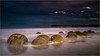
The Journal of Antiquities gives us information about these mysterious oval and spherical-shaped boulders in their entry for The Mysterious Disappearing Boulders, Moeraki Beach, Otago, South Island, New Zealand where they are often half submerged in sand and bedrock.
The Journal tells us these grey boulders are located on Moeraki Beach, Koekohe Beach and Shag Point. "They vary in size but generally they are somewhere between 1 foot 7 inches and 7 foot 2 inches in circumference and in height between 2-8 feet; some are damaged and broken up due to constant erosion from the pounding waves, many others are wonderfully smooth-shaped and ‘naturally patterned’ with unusual circular, diamond and oblong shapes, said to be somewhat similar to ‘the eyes in potatoes’, but with connecting lines. The boulders are made of hardened mud, silt and clay, and they are cemented together with calcite .... which might account for some of the boulders cracking apart".
The JoA also gives a short list of reference sources for more information, including this link to The Mysterious Moeraki Boulders.
Note: Have you visited this site? Do you have any photographs or information to add?
You may be viewing yesterday's version of this page. To see the most up to date information please register for a free account.
 (PID:211319)")
 (PID:211320)")
 (PID:211301)")
Do not use the above information on other web sites or publications without permission of the contributor.
Nearby Images from Flickr


The above images may not be of the site on this page, but were taken nearby. They are loaded from Flickr so please click on them for image credits.
Click here to see more info for this site
Nearby sites
Click here to view sites on an interactive map of the areaKey: Red: member's photo, Blue: 3rd party photo, Yellow: other image, Green: no photo - please go there and take one, Grey: site destroyed
Download sites to:
KML (Google Earth)
GPX (GPS waypoints)
CSV (Garmin/Navman)
CSV (Excel)
To unlock full downloads you need to sign up as a Contributory Member. Otherwise downloads are limited to 50 sites.
Turn off the page maps and other distractions
Nearby sites listing. In the following links * = Image available
55.0km NNW 348° Maerewhenua* Rock Art
57.7km NNW 346° Takiroa Rock Art Site* Cave or Rock Shelter
224.8km WSW 238° Southland Museum and Art Gallery* Museum
245.1km NE 38° Ōhinehou* Ancient Village or Settlement
247.3km NE 36° Canterbury Museum* Museum
252.8km NE 45° Okains Bay Maori and Colonial Museum* Museum
310.8km N 5° Taramakau Pa* Ancient Village or Settlement
495.8km NNE 13° Whakapoāi* Ancient Village or Settlement
524.4km NNE 18° Te Waikoropupu Springs* Holy Well or Sacred Spring
609.0km NE 41° Stonehenge Aotearoa* Modern Stone Circle etc
634.6km NE 40° Wairarapa Stone Circle Modern Stone Circle etc
665.5km SSW 209° Sandy Bay* Ancient Village or Settlement
702.3km NNE 25° Te Uma a Tongahake Pa* Hillfort
702.6km NNE 25° Turuturu Mokai Pa* Hillfort
703.0km NNE 25° Tawhiti Museum* Museum
745.4km NNE 22° Whakawhitiwhiti Pā* Hillfort
748.5km NNE 22° Te Punga a Matori* Sculptured Stone
837.0km NNE 34° Kaimanawa Wall* Natural Stone / Erratic / Other Natural Feature
882.9km NNE 31° Pohaturoa* Hillfort
889.7km NNE 23° Ruapuke Pa* Standing Stone (Menhir)
990.3km NNE 21° Mangere Mountain Pa* Hillfort
993.0km NNE 21° Puketapapa Pa* Hillfort
993.7km NNE 21° Otahuhu Pa* Hillfort
995.6km NNE 21° Maungakiekie Pa* Hillfort
996.0km NNE 21° Cornwall Park Rongo Stone* Standing Stone (Menhir)
View more nearby sites and additional images


 We would like to know more about this location. Please feel free to add a brief description and any relevant information in your own language.
 Wir möchten mehr über diese Stätte erfahren. Bitte zögern Sie nicht, eine kurze Beschreibung und relevante Informationen in Deutsch hinzuzufügen.
 Nous aimerions en savoir encore un peu sur les lieux. S'il vous plaît n'hesitez pas à ajouter une courte description et tous les renseignements pertinents dans votre propre langue.
 Quisieramos informarnos un poco más de las lugares. No dude en añadir una breve descripción y otros datos relevantes en su propio idioma.