<< Text Pages >> Hereheretaura Pā - Hillfort in New Zealand
Submitted by Andy B on Sunday, 17 April 2022 Page Views: 1122
Multi-periodSite Name: Hereheretaura Pā Alternative Name: Hahei Beach Te Pare Historic Reserve, Hahei PāCountry: New Zealand
NOTE: This site is 541.659 km away from the location you searched for.
Type: Hillfort
Latitude: 36.84407S Longitude: 175.817640E
Condition:
| 5 | Perfect |
| 4 | Almost Perfect |
| 3 | Reasonable but with some damage |
| 2 | Ruined but still recognisable as an ancient site |
| 1 | Pretty much destroyed, possibly visible as crop marks |
| 0 | No data. |
| -1 | Completely destroyed |
| 5 | Superb |
| 4 | Good |
| 3 | Ordinary |
| 2 | Not Good |
| 1 | Awful |
| 0 | No data. |
| 5 | Can be driven to, probably with disabled access |
| 4 | Short walk on a footpath |
| 3 | Requiring a bit more of a walk |
| 2 | A long walk |
| 1 | In the middle of nowhere, a nightmare to find |
| 0 | No data. |
| 5 | co-ordinates taken by GPS or official recorded co-ordinates |
| 4 | co-ordinates scaled from a detailed map |
| 3 | co-ordinates scaled from a bad map |
| 2 | co-ordinates of the nearest village |
| 1 | co-ordinates of the nearest town |
| 0 | no data |
Internal Links:
External Links:
At the southern end of Hahei Beach Te Pare Historic Reserve encompasses the remains of two prominent Ngati Hei pā sites. A nearby spring and the remains of several midden suggest the site was a good location for both freshwater and shellfish.
The two pā offered protection to the Ngati Hei people against frequent attacks from Ngati Whanaunga, Ngati Tamatera and Ngapuhi. However, many of these attacks led to considerable loss of life and enslavement.
Hereheretaura Pā is perched on the tip of the headland and surrounded by steep cliffs. The cliffs, coupled with a ditch and bank on the landward side, created a very good defensive position. You can still see the remains of the ditch and bank, several terraces, storage pits, and the living platforms. DOC has repaired the outer earthworks bank, and formed a staircase on to the pā to prevent damage to the midden deposits on the slopes below the terraces.
Hahei Pā is on the ridge above the track leading to Hereheretaura Pā. Steep cliffs on the south drop down to a bay, while on the north side seven terraces fan out around the main platform. Unlike Hereheretaura Pā defensive earthworks appear to have been minimal.
[I haven't done a separate page for this site at the moment by I can do if anyone has any photos - MegP Ed]
Location:
The site is located at the southern end of Hahei Beach. Turn off SH25 between Coroglen and Whenuakite. Before entering Hahei, turn right onto Pa Road. The start of the track is signposted at the end of the road.
A 15 minute walk takes you through an ancient pohutukawa grove to the pā sites. The views from the headland are spectacular, stretching for miles up and down the coast.
Source: New Zealand National Parks
You may be viewing yesterday's version of this page. To see the most up to date information please register for a free account.
Do not use the above information on other web sites or publications without permission of the contributor.
Nearby Images from Flickr
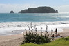
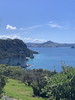
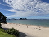
The above images may not be of the site on this page, but were taken nearby. They are loaded from Flickr so please click on them for image credits.
Click here to see more info for this site
Nearby sites
Click here to view sites on an interactive map of the areaKey: Red: member's photo, Blue: 3rd party photo, Yellow: other image, Green: no photo - please go there and take one, Grey: site destroyed
Download sites to:
KML (Google Earth)
GPX (GPS waypoints)
CSV (Garmin/Navman)
CSV (Excel)
To unlock full downloads you need to sign up as a Contributory Member. Otherwise downloads are limited to 50 sites.
Turn off the page maps and other distractions
Nearby sites listing. In the following links * = Image available
52.2km WSW 253° Tapapakanga Park* Ancient Village or Settlement
54.9km W 273° Men's Bay North Pa* Hillfort
73.3km W 273° Matarahui Bay Pa* Hillfort
74.4km W 275° Mokemoke Pa* Hillfort
82.1km W 271° Motukorea Cone Pa* Hillfort
83.0km W 268° Tahuna Torea* Ancient Village or Settlement
84.3km W 268° Taurere Pa* Hillfort
86.5km W 266° Maungarei Pa* Hillfort
87.1km W 266° Maungarei Stonefields* Ancient Village or Settlement
87.5km WNW 288° Tiritiri Matangi Pa* Hillfort
87.5km W 263° Otahuhu Pa* Hillfort
88.1km WNW 288° Papakura Pa* Hillfort
91.6km W 266° Cornwall Park Rongo Stone* Standing Stone (Menhir)
91.7km W 267° Remuera Pa* Hillfort
92.2km W 266° Maungakiekie Pa* Hillfort
92.4km WNW 286° Te Haruhi Bay Kainga* Ancient Village or Settlement
92.4km W 267° Te Kopuke Pa* Hillfort
92.5km W 269° Auckland Museum* Museum
92.6km WNW 286° Shakespear Homestead Pa* Hillfort
92.7km W 262° Mangere Mountain Pa* Hillfort
93.5km W 267° Epsom Modern Megalith* Modern Stone Circle etc
93.8km W 275° Rahopara Pa* Hillfort
93.8km W 267° Maungawhau* Hillfort
94.3km WNW 284° Rakauananga Pa* Hillfort
96.4km WNW 285° Whangaparaoa Stone Folly* Modern Stone Circle etc
View more nearby sites and additional images


 We would like to know more about this location. Please feel free to add a brief description and any relevant information in your own language.
 Wir möchten mehr über diese Stätte erfahren. Bitte zögern Sie nicht, eine kurze Beschreibung und relevante Informationen in Deutsch hinzuzufügen.
 Nous aimerions en savoir encore un peu sur les lieux. S'il vous plaît n'hesitez pas à ajouter une courte description et tous les renseignements pertinents dans votre propre langue.
 Quisieramos informarnos un poco más de las lugares. No dude en añadir una breve descripción y otros datos relevantes en su propio idioma.