<< Our Photo Pages >> Southland Museum and Art Gallery - Museum in New Zealand
Submitted by DrewParsons on Tuesday, 13 January 2015 Page Views: 2169
MuseumsSite Name: Southland Museum and Art GalleryCountry: New Zealand Type: Museum
Nearest Town: Invercargill
Latitude: 46.40527S Longitude: 168.353690E
Condition:
| 5 | Perfect |
| 4 | Almost Perfect |
| 3 | Reasonable but with some damage |
| 2 | Ruined but still recognisable as an ancient site |
| 1 | Pretty much destroyed, possibly visible as crop marks |
| 0 | No data. |
| -1 | Completely destroyed |
| 5 | Superb |
| 4 | Good |
| 3 | Ordinary |
| 2 | Not Good |
| 1 | Awful |
| 0 | No data. |
| 5 | Can be driven to, probably with disabled access |
| 4 | Short walk on a footpath |
| 3 | Requiring a bit more of a walk |
| 2 | A long walk |
| 1 | In the middle of nowhere, a nightmare to find |
| 0 | No data. |
| 5 | co-ordinates taken by GPS or official recorded co-ordinates |
| 4 | co-ordinates scaled from a detailed map |
| 3 | co-ordinates scaled from a bad map |
| 2 | co-ordinates of the nearest village |
| 1 | co-ordinates of the nearest town |
| 0 | no data |
Internal Links:
External Links:
I have visited· I would like to visit
DrewParsons has visited here
")
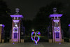
Southland Museum and Art Gallery is located in Invercargill at the southern end of the South Island. It has an excellent display of Maori artifacts including items from the brief 1200 AD Maori settlement on Enderby Island in the Sub Antarctic region. Photography of the exhibits is not permitted without written consent so only the museum building is shown on this page.
You may be viewing yesterday's version of this page. To see the most up to date information please register for a free account.
Do not use the above information on other web sites or publications without permission of the contributor.
Nearby Images from Flickr


The above images may not be of the site on this page, but were taken nearby. They are loaded from Flickr so please click on them for image credits.
Click here to see more info for this site
Nearby sites
Click here to view sites on an interactive map of the areaKey: Red: member's photo, Blue: 3rd party photo, Yellow: other image, Green: no photo - please go there and take one, Grey: site destroyed
Download sites to:
KML (Google Earth)
GPX (GPS waypoints)
CSV (Garmin/Navman)
CSV (Excel)
To unlock full downloads you need to sign up as a Contributory Member. Otherwise downloads are limited to 50 sites.
Turn off the page maps and other distractions
Nearby sites listing. In the following links * = Image available
224.8km ENE 59° Moeraki Beach Boulders (Otago)* Natural Stone / Erratic / Other Natural Feature
248.9km NE 47° Takiroa Rock Art Site* Cave or Rock Shelter
249.8km NE 47° Maerewhenua* Rock Art
463.4km NE 49° Ōhinehou* Ancient Village or Settlement
463.8km NE 48° Canterbury Museum* Museum
474.6km NE 53° Okains Bay Maori and Colonial Museum* Museum
480.3km SSW 198° Sandy Bay* Ancient Village or Settlement
481.4km NNE 28° Taramakau Pa* Ancient Village or Settlement
673.8km NNE 28° Whakapoāi* Ancient Village or Settlement
712.6km NNE 31° Te Waikoropupu Springs* Holy Well or Sacred Spring
826.9km NE 47° Stonehenge Aotearoa* Modern Stone Circle etc
851.7km NE 46° Wairarapa Stone Circle Modern Stone Circle etc
900.1km NE 34° Te Uma a Tongahake Pa* Hillfort
900.3km NE 34° Turuturu Mokai Pa* Hillfort
901.0km NE 35° Tawhiti Museum* Museum
937.3km NNE 32° Whakawhitiwhiti Pā* Hillfort
940.6km NNE 32° Te Punga a Matori* Sculptured Stone
1046.6km NE 40° Kaimanawa Wall* Natural Stone / Erratic / Other Natural Feature
1082.4km NNE 31° Ruapuke Pa* Standing Stone (Menhir)
1088.4km NE 38° Pohaturoa* Hillfort
1178.3km NNE 29° Mangere Mountain Pa* Hillfort
1180.3km NNE 29° Puketapapa Pa* Hillfort
1182.2km NNE 29° Otahuhu Pa* Hillfort
1183.3km NNE 29° Maungakiekie Pa* Hillfort
1183.8km NNE 29° Cornwall Park Rongo Stone* Standing Stone (Menhir)
View more nearby sites and additional images


 We would like to know more about this location. Please feel free to add a brief description and any relevant information in your own language.
 Wir möchten mehr über diese Stätte erfahren. Bitte zögern Sie nicht, eine kurze Beschreibung und relevante Informationen in Deutsch hinzuzufügen.
 Nous aimerions en savoir encore un peu sur les lieux. S'il vous plaît n'hesitez pas à ajouter une courte description et tous les renseignements pertinents dans votre propre langue.
 Quisieramos informarnos un poco más de las lugares. No dude en añadir una breve descripción y otros datos relevantes en su propio idioma.