<< Our Photo Pages >> Vingerklip - Natural Stone / Erratic / Other Natural Feature in Namibia
Submitted by pab on Sunday, 27 January 2013 Page Views: 2645
Natural PlacesSite Name: Vingerklip Alternative Name: Rock FingerCountry: Namibia
NOTE: This site is 248.659 km away from the location you searched for.
Type: Natural Stone / Erratic / Other Natural Feature
Latitude: 20.382849S Longitude: 15.433888E
Condition:
| 5 | Perfect |
| 4 | Almost Perfect |
| 3 | Reasonable but with some damage |
| 2 | Ruined but still recognisable as an ancient site |
| 1 | Pretty much destroyed, possibly visible as crop marks |
| 0 | No data. |
| -1 | Completely destroyed |
| 5 | Superb |
| 4 | Good |
| 3 | Ordinary |
| 2 | Not Good |
| 1 | Awful |
| 0 | No data. |
| 5 | Can be driven to, probably with disabled access |
| 4 | Short walk on a footpath |
| 3 | Requiring a bit more of a walk |
| 2 | A long walk |
| 1 | In the middle of nowhere, a nightmare to find |
| 0 | No data. |
| 5 | co-ordinates taken by GPS or official recorded co-ordinates |
| 4 | co-ordinates scaled from a detailed map |
| 3 | co-ordinates scaled from a bad map |
| 2 | co-ordinates of the nearest village |
| 1 | co-ordinates of the nearest town |
| 0 | no data |
Internal Links:
External Links:
I have visited· I would like to visit
PAB has visited here
")
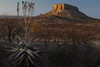
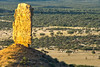
The very impressive natural feature called Rock Finger (Vingerklip in Africaans) stands over 30 metres high. It is probably the most striking structure in the Ugab River valley - an area called the ‘Monument Valley of Namibia’, because of the similarity of much of the area to the famous sites and sights in the US Monument National Park.
The river has cut huge terraces through the area – and local documentation reports that there have been finds dated to ‘Middle Stone Age’ in the various deposits washed down by the river in its occasional flood sequences. I am not sure however how well this period would match to UK interpretation of Middle Stone Age – this after all being considered the cradle of so much human life.
Fuller details of the location and importance of Vingerklip can be found on the Namibian Tourism site: http://www.namibia-1on1.com/vingerklip.html
Site visited May 2012
You may be viewing yesterday's version of this page. To see the most up to date information please register for a free account.
")
Do not use the above information on other web sites or publications without permission of the contributor.
Nearby Images from Flickr


The above images may not be of the site on this page, but were taken nearby. They are loaded from Flickr so please click on them for image credits.
Click here to see more info for this site
Nearby sites
Click here to view sites on an interactive map of the areaKey: Red: member's photo, Blue: 3rd party photo, Yellow: other image, Green: no photo - please go there and take one, Grey: site destroyed
Download sites to:
KML (Google Earth)
GPX (GPS waypoints)
CSV (Garmin/Navman)
CSV (Excel)
To unlock full downloads you need to sign up as a Contributory Member. Otherwise downloads are limited to 50 sites.
Turn off the page maps and other distractions
Nearby sites listing. In the following links * = Image available
5.5km SSE 146° Omburo Ost* Rock Art
112.9km WSW 258° Twyfelfontein* Rock Art
112.9km WSW 258° Twyfelfontein* Stone Circle
113.9km SW 225° The White Lady Group* Rock Art
159.0km S 172° Phillipp's Cave Rock Art
162.2km S 188° Bushman Paradise* Rock Art
165.9km SSE 160° Paula's Cave Rock Art
188.7km SE 144° Oropoko* Rock Art
316.9km SSE 168° Rooisand Rock Painting* Rock Art
341.6km S 181° Mirabib* Natural Stone / Erratic / Other Natural Feature
455.2km NNW 330° Pinturas Rupestres do Monte Negro Rock Art
563.0km NNW 331° Tshitundo Hulo Rock Art
685.2km ENE 76° Tsodilo Hills* Rock Art
713.0km NNW 348° Quilengues Gravures Rupestres Rock Art
732.9km NNW 341° Txipopilu Petroglyphs Rock Art
820.3km SSE 150° The Lost City of Kalahari* Ancient Village or Settlement
832.6km SSE 169° Apollo 11 Cave* Cave or Rock Shelter
945.5km N 7° Moma Rock Art
957.8km S 171° Spitzkloof* Cave or Rock Shelter
1013.4km E 93° Makgadikgadi* Ancient Village or Settlement
1122.0km SE 138° Kathu Pan* Ancient Mine, Quarry or other Industry
1151.3km N 358° Pedra Quissongo Rock Art
1168.8km SE 137° Wonderwerk Cave* Cave or Rock Shelter
1181.1km ESE 114° Matsieng Footprints Rock Art
1191.7km N 1° Pungo Andongo Rock Art
View more nearby sites and additional images


 We would like to know more about this location. Please feel free to add a brief description and any relevant information in your own language.
 Wir möchten mehr über diese Stätte erfahren. Bitte zögern Sie nicht, eine kurze Beschreibung und relevante Informationen in Deutsch hinzuzufügen.
 Nous aimerions en savoir encore un peu sur les lieux. S'il vous plaît n'hesitez pas à ajouter une courte description et tous les renseignements pertinents dans votre propre langue.
 Quisieramos informarnos un poco más de las lugares. No dude en añadir una breve descripción y otros datos relevantes en su propio idioma.