<< Our Photo Pages >> Leivset sacrificial site - Natural Stone / Erratic / Other Natural Feature in Norway
Submitted by kenntha88 on Saturday, 17 November 2007 Page Views: 2963
Natural PlacesSite Name: Leivset sacrificial siteCountry: Norway
NOTE: This site is 43.54 km away from the location you searched for.
Type: Natural Stone / Erratic / Other Natural Feature
Nearest Town: Bodø Nearest Village: Fauske
Latitude: 67.228744N Longitude: 15.407295E
Condition:
| 5 | Perfect |
| 4 | Almost Perfect |
| 3 | Reasonable but with some damage |
| 2 | Ruined but still recognisable as an ancient site |
| 1 | Pretty much destroyed, possibly visible as crop marks |
| 0 | No data. |
| -1 | Completely destroyed |
| 5 | Superb |
| 4 | Good |
| 3 | Ordinary |
| 2 | Not Good |
| 1 | Awful |
| 0 | No data. |
| 5 | Can be driven to, probably with disabled access |
| 4 | Short walk on a footpath |
| 3 | Requiring a bit more of a walk |
| 2 | A long walk |
| 1 | In the middle of nowhere, a nightmare to find |
| 0 | No data. |
| 5 | co-ordinates taken by GPS or official recorded co-ordinates |
| 4 | co-ordinates scaled from a detailed map |
| 3 | co-ordinates scaled from a bad map |
| 2 | co-ordinates of the nearest village |
| 1 | co-ordinates of the nearest town |
| 0 | no data |
Internal Links:
External Links:
")
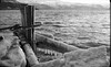
It consists of two natural huge boulders laying with a small space betwen them, but it is also consisting of a low stone wall around it. This has made specualtions that it is maybe not a sami sacrificial place, but maybe far older and maybe of a different origin, however it is most likely that it is of sami origin.
It is a very interesting place, but unfortunately it is very overgrown with small bushes and bigger trees and can be hard to find. It was also difficult to photograph because of the growth.
Note: Coordinates revised in August 2009
You may be viewing yesterday's version of this page. To see the most up to date information please register for a free account.
")
")
Do not use the above information on other web sites or publications without permission of the contributor.
Nearby Images from Flickr
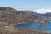
The above images may not be of the site on this page, but were taken nearby. They are loaded from Flickr so please click on them for image credits.
Click here to see more info for this site
Nearby sites
Click here to view sites on an interactive map of the areaKey: Red: member's photo, Blue: 3rd party photo, Yellow: other image, Green: no photo - please go there and take one, Grey: site destroyed
Download sites to:
KML (Google Earth)
GPX (GPS waypoints)
CSV (Garmin/Navman)
CSV (Excel)
To unlock full downloads you need to sign up as a Contributory Member. Otherwise downloads are limited to 50 sites.
Turn off the page maps and other distractions
Nearby sites listing. In the following links * = Image available
17.5km W 274° Ljønes burial site* Barrow Cemetery
18.7km WNW 293° Mjønes burial site* Barrow Cemetery
19.6km W 270° Kvistadvika settlement* Ancient Village or Settlement
28.7km NNE 16° Daumannvikflåget* Natural Stone / Erratic / Other Natural Feature
29.7km W 278° Godøynes* Barrow Cemetery
33.1km W 271° Saltstraumen* Barrow Cemetery
34.3km W 268° Tuv Storåsen* Standing Stones
35.5km W 280° Fenes* Standing Stone (Menhir)
38.0km WSW 256° Øvre Kvikstad* Standing Stone (Menhir)
41.6km W 279° Vågøynes monument* Standing Stones
42.5km W 280° Opplia* Standing Stone (Menhir)
44.3km W 278° Bodø Standing Stone* Standing Stone (Menhir)
44.5km W 278° Nordland Museum, Bodø* Museum
55.9km NNE 19° Mørsvikbotn sacrificial site* Natural Stone / Erratic / Other Natural Feature
73.5km S 182° Stødi sacrificial site* Natural Stone / Erratic / Other Natural Feature
77.2km NNE 14° Sagelv* Carving
77.6km SW 232° Fykan Carvings* Carving
78.6km NNW 348° Gjerdet* Round Barrow(s)
78.8km N 350° Sandvågen altar* Carving
80.2km NNW 347° Langsteinen* Standing Stone (Menhir)
80.6km NNW 347° Hagbardsholmen Island burial field* Barrow Cemetery
81.5km N 353° Hammarhaugen* Barrow Cemetery
81.8km NNW 347° Vollmoen settlement* Ancient Village or Settlement
82.4km NNW 348° Steigskardet burial mounds* Round Barrow(s)
82.9km NNW 348° Bø settlement* Ancient Village or Settlement
View more nearby sites and additional images


 We would like to know more about this location. Please feel free to add a brief description and any relevant information in your own language.
 Wir möchten mehr über diese Stätte erfahren. Bitte zögern Sie nicht, eine kurze Beschreibung und relevante Informationen in Deutsch hinzuzufügen.
 Nous aimerions en savoir encore un peu sur les lieux. S'il vous plaît n'hesitez pas à ajouter une courte description et tous les renseignements pertinents dans votre propre langue.
 Quisieramos informarnos un poco más de las lugares. No dude en añadir una breve descripción y otros datos relevantes en su propio idioma.