

<< Our Photo Pages >> Dolmen di Avola - Natural Stone / Erratic / Other Natural Feature in Italy in Sicily (Sicilia)
Submitted by Salvatore on Sunday, 05 December 2010 Page Views: 10365
Natural PlacesSite Name: Dolmen di Avola Alternative Name: Dolmen Lido Di AvolaCountry: Italy
NOTE: This site is 6.672 km away from the location you searched for.
Region: Sicily (Sicilia) Type: Natural Stone / Erratic / Other Natural Feature
Nearest Town: Avola Nearest Village: Avola
Latitude: 36.930650N Longitude: 15.157570E
Condition:
| 5 | Perfect |
| 4 | Almost Perfect |
| 3 | Reasonable but with some damage |
| 2 | Ruined but still recognisable as an ancient site |
| 1 | Pretty much destroyed, possibly visible as crop marks |
| 0 | No data. |
| -1 | Completely destroyed |
| 5 | Superb |
| 4 | Good |
| 3 | Ordinary |
| 2 | Not Good |
| 1 | Awful |
| 0 | No data. |
| 5 | Can be driven to, probably with disabled access |
| 4 | Short walk on a footpath |
| 3 | Requiring a bit more of a walk |
| 2 | A long walk |
| 1 | In the middle of nowhere, a nightmare to find |
| 0 | No data. |
| 5 | co-ordinates taken by GPS or official recorded co-ordinates |
| 4 | co-ordinates scaled from a detailed map |
| 3 | co-ordinates scaled from a bad map |
| 2 | co-ordinates of the nearest village |
| 1 | co-ordinates of the nearest town |
| 0 | no data |
Be the first person to rate this site - see the 'Contribute!' box in the right hand menu.
Internal Links:
External Links:
I have visited· I would like to visit
Andy B has visited here
")
Avola is a big coastal city which lies between the River Assinaro and River Cassibile, some twenty kilometres south of Syracuse on the eastern coast of the island. No literary source mentions what might have been one of the most ancient cities of Sicily, where, in and around the immediate territory, archaeological evidence of quite remote times can be found. Traces that back up the theory are present on the mountain above [Ref 32], where the mediaeval city stood before an earthquake destroyed it in 1693, so being abandoned for the present site. Greco-Roman statuettes [33], ruins of a 1st century B.C. villa [34] and numerous Christian Hypogeum [35] have come to light.
Along the main road that goes to Syracuse, to the right of the Avola City Hospital a somewhat narrow track opens up and runs along a bed of a torrent. The slow process of waterway erosion has outlined a valley there, called Cava L’Unica. It is here on the right under a low rock face the presumable megalithic monument is situated. This area which is outside of the city centre is indicated with the name Contrada Borgellusa.
The dolmen, discovered by a teacher from Avola, Salvatore Ciancio in 1961, was covered with earth in such a way to seem part of the rock behind. The semblance of an entrance had always given the idea of a cave.
Professor Ciancio ended up convinced he had come across an ancient artefact, after he had carefully examined the ravine, and that it risked remaining hidden away from study. The credibility and seriousness of the researcher convinced the administrators of the local authorities of the time to clear the area near the structure, so freeing a literally unique architectural structure from under the heap that had built up over the centuries. Strong discussion arose between Salvatore Ciancio, who was certain it was a megalith, and the official science of the time.
The civic Assembly of Avola, confiding in the documentation of their illustrious citizen, thought well to fence off and prohibit access to the area to avoid any unlawful building speculation, or intrusion, damaging the find. Unfortunately, at that time much uncontrollable and illegal construction was being carried out even in places that were known to be rich in archaeological sites. The press gave a lot of coverage and importance to the discovery, reporting the visits of important archaeologists to the so-called dolmen in great detail.
Visits followed from Luigi Bernabò Bea, the then Superintendent of Monuments and Fine Arts, Syracuse, and Giorgio Vinicio Gentili an inspector of the same organisation. They were inclined to have many doubts, as picked up from press reports. The same doubts were held by Giuseppe and Santi Luigi Agnello [36], and Paolo Griffo, the Superintendent of Agrigento.
Giuseppe Laghi, a Dominican monk and lecturer in the History of Art at Florence University, was among others who visited too. He showed great interest in the “monument” promising to go into the studies. Daniel F. McCall, Rector of the Faculty of Ethnology, Boston University, who visited in 1964, came to the conclusion that the characteristic construction could have been rightly listed as a Megalithic work [37].
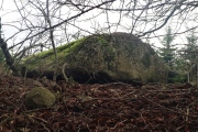
The building which today is surrounded by thick and wild vegetation seems, at first sight, to be made of one enormous “chalk slab” of varying thickness, essentially placed on two “pillars”. Fracturing of the stone necessitated the erection of three brick supports. The work was carried out by the local authorities. The stone is really huge with a corrugated surface. It is almost eight metres in length and five and a half metres in width.
The north-facing part of the platform, which seems to be resting on one isolated and irregular-shaped pillar stone, is more compact. It thins down to approximately half a metre in thickness at the eastern part which, in turn, rests on what could be called a very wide earthen base.
The rock wall behind, from which the enormous slab has objectively broken off because of a fracture line, blocks, in a south-westerly direction, the back part in a semi-circle. The left “pillar” is connected to this wall.
On the surface of the slab, which is broken in two places, ten small rectangular hollows are to be seen. They were worked into the thicker part of the flattish stone, in different directions so that they would not weaken it. The niches are of different lengths, ranging between sixty centimetres and one metre twenty of the last hollow, which is interrupted by the fracture of the southern extremity. The depth does not exceed forty centimetres.
We are perhaps in front of a tomb for children, used in Greek or Paleochristian times. At the time of his discovery, Ciancio found no element to date the construction. But, considering the aversion of early Christians towards burying their dead in places that were easy to find, due to the fact that they were more exposed to plunder, he deduced it was used in the Greek period.
Two grooves run along the outmost eastern side of the slab and they meet at a right-angle. Certain fantastic “literature” of the period came to the conclusion that these two incisions could be defined as draining lines for the blood of sacrifice victims to run along. Instead, they are notches resulting from the extraction of a block of limestone, of about one cubic metre, drawn from the point where the thickness was fitting.
A cavern of 30 sq ms opens up underneath the platform. It is open on two sides (north-west and north-east) and a little more than a metre and a half in height. The error of speaking too soon might have been the result of just a superficial look at the structure. However, this was avoided with the help of the geologist Doctor Giuseppe Ansaldi whose technical judgement brings us to the prologue and, at the same time, the wish to investigate at 360°:
“We are looking at a small grotto that was cut out of Pleistocene chalk by marine abrasion. The site comprises alternating strata of a more substantial competence, between 0.50 and 1.20 metres in thickness, with layers of gritty sand, some centimetres thick.
The wall follows a discontinuous line facing NW-SE, along which, at this point, there is river erosion. There are also minor faults and veins that derive from a sub-perpendicular system to the one described; N 30°- 35° E direction. The intersection of the two discontinuous lines, easy to see on the front face , has dismembered the rock in contiguous blocks of differing volume. Influenced by these geomorphic elements, both fluvial and marine abrasive erosion has taken place.
The formation of the cavity is the result of selective erosive action of the rock, with a more rapid and intense cutting away of the softer basal part (decimetre strata of gritty sand), up to contact with the bank above it which is more compact and resistant, so acting as the roof of the cavity.
The continuing action of erosive processes, rifts, seismic events and Bradisism, involving the area in question, have brought to light submerged settlements and handicrafts of historic and prehistoric eras. Moreover, they caused the detachment of the cavity from the rock wall. It underwent roto-translation downhill with a large breach opening upstream and a tilting of the vault support to the right, as can be seen by the accentuated anomalous dipping of the gritty sand strata it comprises.
The breaking away of the cavity from the wall is chronologically later than the pre-existing tombs made on the surface of the bank overlapping it. This is clearly shown by the fact that the breach produced on the wall snapped some of the existing sepulchral cells on the upper surface of the overhead bank.
With the back-up of observations carried out, there is no doubt this is a natural form of erosion, which is quite frequent along coastal cliffs and river valley banks. It is equally evident that in prehistoric times the original natural form was reshaped by the hand of man following the natural lines of the boulder, intending to amplify and geometrically refine the cavity to its present appearance. Traces of such intervention are visible both around the pillars taken from the side walls of the grotto, giving them a pseudo-parallelepiped form, and in the flat surface of the calcarenite vault. The base of the vault has been cleared of underlying sandy-arenite materials, following the surface of lower stratification”
The geologist’s analysis, therefore, does not preclude the intervention of man on a natural fixture that might have been adapted to experimental architectural elaboration. Perhaps the intervention was for dwelling purposes, though impeded somewhat by its structural appearance: the side openings are incompatible to the logic of a domestic refuge. If an occasional refuge was to be contemplated, the work performed by humans has made it so vulnerable that this possibility of “shelter” is just not logical.
The expedient, instead, seems to be an effort to “monumentalise” a structure provided by Nature, saving man from the bulk of the work. It can be compared to any well-thought out Megalithic construction in Atlantic Europe.
South-eastern Sicily has been witness to the dolmen phenomena, as attested by the numerous reports between 1960-1980, indicating Giarratana, Marina di Modica and Noto. An exceptionally large trilithic (three-stone) construction was found in Belvedere, a panoramic area above Syracuse.
Other traces came to light in Solarino, near the Corruggi manor farm: four vertical stones in a circle, little more than one metre high, bore a boulder which served as a cover. The shape of the building, according to Professor Rodolfo Striccoli, lecturer of Prehistory and Protohistory at Bari University, was reminiscent of a well-known dolmen typology present in Apulia38. There is nothing remaining of the ruin as it was covered by tons of earth during work on an enormous dam for hydro-electric power in that very place. Similar constructions are claimed to have been on that site too. A megalithic work also existed near the River Mulinello, in Villasmundo (Melilli), in the Petraro district.
Just a few faded photographs remain as witness to its presence. They show an enormous block which had once been fitted onto two vertical stones, remaining so fixed only on one column as the other must have accidentally slid on land that had been beaten by centuries of weathering.
Getting back to the “pseudo” dolmen of Avola, it is opportune to clarify that there is no intention to justify its status through simple analyses of the exterior, nor, though, is it wise to consider the archaeological investigations superfluous. On the contrary, however, we must be convinced of the opportune incontrovertible action of the pickaxe, in order to solve a doubt that has been there for more than forty years.
Technical data of the monument.
length of horizontal slab 7.90 ms
width of horizontal slab 5.50 ms
thickness of horizontal slab 1.70 down to 0.60 ms
height of ground-level to the right 1.12 ms
height of ground-level to the left 1.47 ms
length of burial niches (N°. 10) 0.60 up to 1.20 ms
width of burial niches 0.26 up to 0.54 ms
depth of burial niches 0.40 ms
measurement of the incision
carried out in the chalky slab 1.00 x 1.00 ms
depth of the cut 0.60 ms
cavern surface 30 sq ms
cavity height 1.45 up to 1.50 ms
bearings 35° NE
Geographical map reference I.G.M. 1/25.000 – F° 277 IV NE
References:
32 P. Orsi, Avola. Sepolcri siculi e catacombe cristiane, in «Notizie Scavi di antichità», 1899, pp. 69-70.
33 G.V. Gentili, «Fasti archeologici»IX, 1954[1956], n.r. 2792.
34 M. T. Currò, Avola. Casa romana in contrada Borgellusa, in «Boll. D’Arte», LI, 1966, p. 94; cf. also G.M. Bacci, Avola (1980-1983). Villa ellenistico-romana in contrada Borgellusa, in «Kokalos», II 1984-1985, pp.711 on.
35 R. M. Albanese, Notiziario, Avola, in «Studi Etruschi», XLVI, 1978, pp. 569-571.
36 Father and son, both renowned lecturers of Christian Archaeology at Catania University.
37 S. Piccolo, ibidem, XVIII.
38 Cf. Le ruspe travolgono un prezioso dolmen, in «La Domenica», a Syracuse weekly, 25th September 1983.
Information from Salvatore Piccolo's book,
"Antiche Pietre. La cultura dei dolmen nella preistoria della Sicilia sud-orientale",
Morrone editore, Siracusa 2007.
The text comes from an experimental degree thesis in Archaeological Cultural Heritage (University of Palermo 1994/1995) where the author deals with a topic never previously discussed in Sicily: the presence of dolmens. This discovery of the Mediterranean island will facilitate the understanding of the processes of migration occurred from the north to the south of Europe between 4500 B.C. and 1800 B.C. The archaeological evidence gathered by the author shows that at least one of these monuments, namely that of “Cava dei Servi”, was used as a burial place between the end of the 3rd and the first half of the 2nd millennium B.C., making known their purpose.
The first chapter deals with the origin of these huge stone monuments that, according to the Australian archaeologist V. Gordon Childe, were erected by mythical megalithic missionaries, members of some early Aegean tribes, of the eastern Mediterranean. The perfection of the absolute dating system (C14), has proved that the oldest megalithic tombs originated in central-north Europe around 4500 B.C. The principal characteristics of the dolmens (menhir, cromlech) of Britain and England are then described, going on to ponder Mediterranean dolmens (Spain, Balearic Island, Sardinia, Apulia). The chapter ends with the discovery of dolmens in Sicily.
The second chapter is about Sicilian dolmens: Monte Bubbonia, Cava dei Servi, Cava Lazzaro, Avola; every dolmen is different from another, but they all exist in a European typology. In Cava dei Servi the author found anthropological remains that confirm the burial purpose of the artefact, while the few earthenware fragments legitimise dating them back to the early Bronze Age. The dolmen of Avola is a natural structure that has been worked on by hand, as certified by the analysis carried out, only for this text, by a geological laboratory.
The third chapter ends with some conclusions that would clarify the disappearance of a big Maltese civilization that had lived between 4000 B.C. and 2200 B.C.: the Tarxien Culture. Till now, the archaeologist Themistocles Zammit attributed the disappearance of that culture to an epidemic. In the late 50’s, the English archaeologist, J.D.Evans, believed that there had been an Apulian invasion. This is due to the analogy of dolmens present in Malta with that of Apulia.
The discovery, to date, of dolmens also in Sicily, similar to those of Apulia and Malta, disproves this thesis. We can hence assert that the Tarxien civilization disappeared because of a Sicilian population which superimposed the successive “Tarxien cemetery culture”, dolmens bearer.
Finally, this book, intends to make it known to the scholars of the world that also Sicily is a land of dolmens, so to motivate them towards new hypotheses.
The text, written clearly and in easy language, includes an interesting international bibliography, more than 60 notes as well as the quotation of famous books which can be consulted in the most prestigious university libraries of the world.
The text is also easy to be read by an “amateur” public because it is written in plain language, explaining the technicalities. There are 69 pages as the author wanted to be honest with his readers, avoiding topics that have already been mentioned and written about thousands of times, maintaining only the originality of the Sicilian discoveries.
You may be viewing yesterday's version of this page. To see the most up to date information please register for a free account.
")
")
")
")
")
")
")
")
Do not use the above information on other web sites or publications without permission of the contributor.
Click here to see more info for this site
Nearby sites
Click here to view sites on an interactive map of the areaKey: Red: member's photo, Blue: 3rd party photo, Yellow: other image, Green: no photo - please go there and take one, Grey: site destroyed
Download sites to:
KML (Google Earth)
GPX (GPS waypoints)
CSV (Garmin/Navman)
CSV (Excel)
To unlock full downloads you need to sign up as a Contributory Member. Otherwise downloads are limited to 50 sites.
Turn off the page maps and other distractions
Nearby sites listing. In the following links * = Image available
12.0km W 278° Noto antica* Ancient Village or Settlement
16.4km NE 34° Syracuse Temple of Olympian Zeus Ancient Temple
18.7km NE 40° Ortigia Temple of Athena* Ancient Temple
19.1km NE 39° Ortigia Temple of Apollo* Ancient Temple
19.1km NNE 33° Syracuse Archaeological Park* Museum
19.5km NE 37° Paolo Orsi Museo Archeologico Museum
20.2km W 280° Castelluccio Necropolis Rock Cut Tomb
23.7km WSW 255° Cava Lazzaro* Burial Chamber or Dolmen
25.6km NNW 333° The Anaktoron Palace* Ancient Palace
26.0km NNW 331° Pantalica Rock Cut Tombs* Rock Cut Tomb
26.7km WNW 301° Santoni* Carving
27.3km WNW 301° Akrai* Ancient Village or Settlement
29.6km W 268° Cava dei Servi* Burial Chamber or Dolmen
29.7km WSW 253° Cava D'Ispica* Rock Cut Tomb
30.5km N 4° Megara Hyblaea* Ancient Village or Settlement
34.3km NW 308° The neviere of Buccheri* Artificial Mound
63.5km W 264° Kamarina Ancient Village or Settlement
80.6km WNW 297° Monte Bubbonia* Chambered Tomb
81.3km W 281° Archaeological museum (Gela)* Museum
81.8km NW 313° Morgantina* Ancient Village or Settlement
83.8km W 281° Bagni Greci* Ancient Village or Settlement
84.4km W 281° Capo Soprano* Hillfort
87.5km NW 304° Villa imperiale del Casale* Ancient Palace
103.2km N 7° Taormina* Ancient Village or Settlement
117.0km N 1° Grotta Grottona* Cave or Rock Shelter
View more nearby sites and additional images


 We would like to know more about this location. Please feel free to add a brief description and any relevant information in your own language.
 Wir möchten mehr über diese Stätte erfahren. Bitte zögern Sie nicht, eine kurze Beschreibung und relevante Informationen in Deutsch hinzuzufügen.
 Nous aimerions en savoir encore un peu sur les lieux. S'il vous plaît n'hesitez pas à ajouter une courte description et tous les renseignements pertinents dans votre propre langue.
 Quisieramos informarnos un poco más de las lugares. No dude en añadir una breve descripción y otros datos relevantes en su propio idioma.