 with our Megalithic Portal iPhone app")

<< Our Photo Pages >> Tobinitai - Ancient Village or Settlement in Japan in Hokkaidō
Submitted by Aska on Sunday, 19 December 2021 Page Views: 544
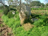
Early Medieval (Dark Age)Site Name: Tobinitai Alternative Name: トビニタイ 飛仁帯Country: Japan
NOTE: This site is 247.486 km away from the location you searched for.
Region: Hokkaidō Type: Ancient Village or Settlement
Nearest Town: Rausu-chō (Hokkaidō prefecture Nearest Village: Kaigan-chō 海岸町
Latitude: 44.043650N Longitude: 145.226670E
Condition:
| 5 | Perfect |
| 4 | Almost Perfect |
| 3 | Reasonable but with some damage |
| 2 | Ruined but still recognisable as an ancient site |
| 1 | Pretty much destroyed, possibly visible as crop marks |
| 0 | No data. |
| -1 | Completely destroyed |
| 5 | Superb |
| 4 | Good |
| 3 | Ordinary |
| 2 | Not Good |
| 1 | Awful |
| 0 | No data. |
| 5 | Can be driven to, probably with disabled access |
| 4 | Short walk on a footpath |
| 3 | Requiring a bit more of a walk |
| 2 | A long walk |
| 1 | In the middle of nowhere, a nightmare to find |
| 0 | No data. |
| 5 | co-ordinates taken by GPS or official recorded co-ordinates |
| 4 | co-ordinates scaled from a detailed map |
| 3 | co-ordinates scaled from a bad map |
| 2 | co-ordinates of the nearest village |
| 1 | co-ordinates of the nearest town |
| 0 | no data |
Internal Links:
External Links:
")
Like Yayoi pottery, they were named after the place name, “Tobinitai pottery”. It seems that the Okhotsk fisherman’s culture from Sakhalin or Kuril islands gradually fused with long-hostiled Hokkaidō native’s farmer culture in 9th C. The excavated pit houses of them also indicates the hybrid style of the square plan of Satsumon culture with central hearth of Okhotsk culture. At last this hybrid culture was absorbed into Satsumon culture in 13th C.
Registered as a UNESCO World Heritage Site.
You may be viewing yesterday's version of this page. To see the most up to date information please register for a free account.
Do not use the above information on other web sites or publications without permission of the contributor.
Nearby Images from Flickr


The above images may not be of the site on this page, but were taken nearby. They are loaded from Flickr so please click on them for image credits.
Click here to see more info for this site
Nearby sites
Click here to view sites on an interactive map of the areaKey: Red: member's photo, Blue: 3rd party photo, Yellow: other image, Green: no photo - please go there and take one, Grey: site destroyed
Download sites to:
KML (Google Earth)
GPX (GPS waypoints)
CSV (Garmin/Navman)
CSV (Excel)
To unlock full downloads you need to sign up as a Contributory Member. Otherwise downloads are limited to 50 sites.
Turn off the page maps and other distractions
Nearby sites listing. In the following links * = Image available
41.1km SSW 194° Ichani Karikariusu Chashi* Hillfort
41.2km SSW 194° Ichani Karikariusu* Ancient Village or Settlement
42.3km WSW 248° Shuen* Henge
46.6km WSW 252° OkushibetsuGawa* Stone Circle
76.5km W 268° KatsuragaOka Toride* Hillfort
76.7km W 269° Moyoro Kaizuka* Ancient Village or Settlement
79.9km W 267° Abashiri prison* Modern Stone Circle etc
85.4km SSE 148° Wonnemoto Chashi* Hillfort
92.2km W 276° Tokor Chashi* Hillfort
96.3km W 276° SakaeUra Iseki* Ancient Village or Settlement
100.6km W 276° Tokoro Iseki* Ancient Village or Settlement
115.4km SSW 195° Shika-otoshi-no Chashi* Hillfort
135.6km SSW 210° Mosirya Chashi* Hillfort
135.7km SSW 209° Charanke Chashi* Hillfort
135.9km WSW 242° Yuk'epira Chashi* Hillfort
175.6km SW 220° Otafunbe Chashi* Hillfort
245.2km W 263° Kamui-Kotan stone circle* Stone Circle
246.0km WSW 256° Nokanan henge* Henge
259.3km W 262° Otoe* Stone Circle
270.7km WSW 259° Hokkaidō Children's Land* Modern Stone Circle etc
295.7km SW 232° Mena Chashi* Hillfort
299.5km SW 232° Sibecar Chashi* Hillfort
300.0km SW 232° Hoinasir Chashi* Hillfort
311.2km WSW 247° Kiusu* Henge
315.9km WSW 252° Ebetsu Chashi* Hillfort
View more nearby sites and additional images


 We would like to know more about this location. Please feel free to add a brief description and any relevant information in your own language.
 Wir möchten mehr über diese Stätte erfahren. Bitte zögern Sie nicht, eine kurze Beschreibung und relevante Informationen in Deutsch hinzuzufügen.
 Nous aimerions en savoir encore un peu sur les lieux. S'il vous plaît n'hesitez pas à ajouter une courte description et tous les renseignements pertinents dans votre propre langue.
 Quisieramos informarnos un poco más de las lugares. No dude en añadir una breve descripción y otros datos relevantes en su propio idioma.