<< Text Pages >> Berglitzl - Rock Art in Austria
Submitted by Kaihofmann on Saturday, 11 February 2012 Page Views: 2748
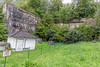
Rock ArtSite Name: BerglitzlCountry: Austria
NOTE: This site is 29.126 km away from the location you searched for.
Type: Rock Art
Nearest Town: Linz Nearest Village: Enns
Latitude: 48.249770N Longitude: 14.458640E
Condition:
| 5 | Perfect |
| 4 | Almost Perfect |
| 3 | Reasonable but with some damage |
| 2 | Ruined but still recognisable as an ancient site |
| 1 | Pretty much destroyed, possibly visible as crop marks |
| 0 | No data. |
| -1 | Completely destroyed |
| 5 | Superb |
| 4 | Good |
| 3 | Ordinary |
| 2 | Not Good |
| 1 | Awful |
| 0 | No data. |
| 5 | Can be driven to, probably with disabled access |
| 4 | Short walk on a footpath |
| 3 | Requiring a bit more of a walk |
| 2 | A long walk |
| 1 | In the middle of nowhere, a nightmare to find |
| 0 | No data. |
| 5 | co-ordinates taken by GPS or official recorded co-ordinates |
| 4 | co-ordinates scaled from a detailed map |
| 3 | co-ordinates scaled from a bad map |
| 2 | co-ordinates of the nearest village |
| 1 | co-ordinates of the nearest town |
| 0 | no data |
Be the first person to rate this site - see the 'Contribute!' box in the right hand menu.
Internal Links:
External Links:
Rock Art in
This site is one of the most important prehistoric sites of the Danube area. The first human traces are Palaeolithic pavings of the Auricnacian (40.000 BCE). In the Mesolithic it was used as a polissoir. From the Neolithic to the Bronze Age it was a sanctuary with a cup-marked stone. Later in the early medieval (8th-10th Century) it was used as a cemetery.
You may be viewing yesterday's version of this page. To see the most up to date information please register for a free account.
Do not use the above information on other web sites or publications without permission of the contributor.
Nearby Images from Flickr


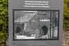
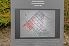
The above images may not be of the site on this page, but were taken nearby. They are loaded from Flickr so please click on them for image credits.
Click here to see more info for this site
Nearby sites
Click here to view sites on an interactive map of the areaKey: Red: member's photo, Blue: 3rd party photo, Yellow: other image, Green: no photo - please go there and take one, Grey: site destroyed
Download sites to:
KML (Google Earth)
GPX (GPS waypoints)
CSV (Garmin/Navman)
CSV (Excel)
To unlock full downloads you need to sign up as a Contributory Member. Otherwise downloads are limited to 50 sites.
Turn off the page maps and other distractions
Nearby sites listing. In the following links * = Image available
18.8km WNW 291° Kuernbergwald Huegelgraeberfeld Barrow Cemetery
45.1km N 3° U svatého Kamene* Sculptured Stone
48.5km NE 45° Wackelstein bei Harruck* Natural Stone / Erratic / Other Natural Feature
51.8km NE 45° Thail Opferstein* Natural Stone / Erratic / Other Natural Feature
51.8km NE 45° Summstein Thail* Modern Stone Circle etc
53.8km NE 42° Kierlingstein* Natural Stone / Erratic / Other Natural Feature
56.1km NE 46° Weltkugel* Natural Stone / Erratic / Other Natural Feature
57.4km NE 51° Gross Gerungs Steinpyramide* Pyramid / Mastaba
59.6km NNE 32° Steinernes Weib* Sculptured Stone
63.0km NE 43° Summstein Thaya* Modern Stone Circle etc
68.1km S 190° In der Höll petroglyphs Rock Art
69.5km E 80° Gars-Thunau Hillfort* Hillfort
69.9km NNW 348° Capuchin Menhir* Standing Stone (Menhir)
70.4km E 83° Venus of Willendorf* Ancient Village or Settlement
70.7km NE 34° Teufelsbett Blockheide* Natural Stone / Erratic / Other Natural Feature
70.7km NE 34° Teufelsbrotlaib* Natural Stone / Erratic / Other Natural Feature
70.7km NE 34° Schuldstein* Natural Stone / Erratic / Other Natural Feature
70.8km NE 34° Schwedenkreuz* Ancient Cross
70.9km NE 34° Cristophstein* Natural Stone / Erratic / Other Natural Feature
70.9km NNW 349° Healers Menhirs* Standing Stones
71.0km NE 34° Wackelstein II Blockheide* Natural Stone / Erratic / Other Natural Feature
71.0km NNE 34° Koboldsteine* Natural Stone / Erratic / Other Natural Feature
71.0km NNE 34° Wackelstein I Blockheide* Natural Stone / Erratic / Other Natural Feature
71.1km NNE 34° Pyramidenstein* Natural Stone / Erratic / Other Natural Feature
71.3km N 354° Třísov Oppidum* Hillfort
View more nearby sites and additional images


 We would like to know more about this location. Please feel free to add a brief description and any relevant information in your own language.
 Wir möchten mehr über diese Stätte erfahren. Bitte zögern Sie nicht, eine kurze Beschreibung und relevante Informationen in Deutsch hinzuzufügen.
 Nous aimerions en savoir encore un peu sur les lieux. S'il vous plaît n'hesitez pas à ajouter une courte description et tous les renseignements pertinents dans votre propre langue.
 Quisieramos informarnos un poco más de las lugares. No dude en añadir una breve descripción y otros datos relevantes en su propio idioma.