<< Our Photo Pages >> Ankoku-ji temple - Modern Stone Circle etc in Japan in Honshū
Submitted by Aska on Sunday, 01 March 2020 Page Views: 405
Medieval (High and Late)Site Name: Ankoku-ji temple Alternative Name: 安国寺Country: Japan
NOTE: This site is 17.307 km away from the location you searched for.
Region: Honshū Type: Modern Stone Circle etc
Nearest Town: Fukuyama (Hiroshima prefecture) Nearest Village: Tomo-chō 鞆町
Latitude: 34.388200N Longitude: 133.379700E
Condition:
| 5 | Perfect |
| 4 | Almost Perfect |
| 3 | Reasonable but with some damage |
| 2 | Ruined but still recognisable as an ancient site |
| 1 | Pretty much destroyed, possibly visible as crop marks |
| 0 | No data. |
| -1 | Completely destroyed |
| 5 | Superb |
| 4 | Good |
| 3 | Ordinary |
| 2 | Not Good |
| 1 | Awful |
| 0 | No data. |
| 5 | Can be driven to, probably with disabled access |
| 4 | Short walk on a footpath |
| 3 | Requiring a bit more of a walk |
| 2 | A long walk |
| 1 | In the middle of nowhere, a nightmare to find |
| 0 | No data. |
| 5 | co-ordinates taken by GPS or official recorded co-ordinates |
| 4 | co-ordinates scaled from a detailed map |
| 3 | co-ordinates scaled from a bad map |
| 2 | co-ordinates of the nearest village |
| 1 | co-ordinates of the nearest town |
| 0 | no data |
Internal Links:
External Links:
")
A temple in a beautiful fisherman village has a dry landscape garden built by a samurai-monk Ekei ANKOKUJI (安国寺恵瓊 1537?-1600) who was executed after the 1600 battle for Japanese unification hegemony.
You may be viewing yesterday's version of this page. To see the most up to date information please register for a free account.
")
Do not use the above information on other web sites or publications without permission of the contributor.
Nearby Images from Flickr

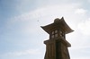

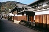
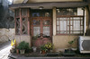

The above images may not be of the site on this page, but were taken nearby. They are loaded from Flickr so please click on them for image credits.
Click here to see more info for this site
Nearby sites
Click here to view sites on an interactive map of the areaKey: Red: member's photo, Blue: 3rd party photo, Yellow: other image, Green: no photo - please go there and take one, Grey: site destroyed
Download sites to:
KML (Google Earth)
GPX (GPS waypoints)
CSV (Garmin/Navman)
CSV (Excel)
To unlock full downloads you need to sign up as a Contributory Member. Otherwise downloads are limited to 50 sites.
Turn off the page maps and other distractions
Nearby sites listing. In the following links * = Image available
4.3km NW 324° Jōkoku-ji temple* Modern Stone Circle etc
15.8km W 280° Jōdo-ji temple* Modern Stone Circle etc
19.9km SW 236° Ōjizuka* Chambered Cairn
25.6km NNW 339° Oichi Kofun* Passage Grave
32.3km WNW 302° Kui-no Gankai* Natural Stone / Erratic / Other Natural Feature
36.9km ENE 60° Hōtō-ji temple* Modern Stone Circle etc
37.3km SE 138° Kōshōjiyama Kofungun* Passage Grave
38.0km WSW 246° Ōmishima Bijutsukan art gallery* Modern Stone Circle etc
38.4km ESE 120° Ōkubo Kyōzuka Kofun* Chambered Cairn
39.0km SE 127° Yaobikuni-tō* Ancient Temple
39.1km NE 53° Mizue Kofun* Chambered Cairn
39.1km NW 321° Yano-no Gankai* Natural Stone / Erratic / Other Natural Feature
39.9km ENE 76° Nozaki Family Residence garden* Modern Stone Circle etc
41.1km ESE 119° Miyagao Kofun* Passage Grave
41.2km ESE 116° Suriusuyama Kofun* Passage Grave
41.3km ESE 119° Kawaratani Kofungun* Passage Grave
42.2km E 100° Shōtsūjiyama Kofun* Chambered Cairn
42.5km ESE 120° Notanoin Kofun* Chambered Cairn
42.7km ESE 118° Oka Kofungun* Passage Grave
42.9km ENE 57° Achi Jinja shrine* Natural Stone / Erratic / Other Natural Feature
43.4km ESE 118° Ōsayama Kyōzuka Kofun* Chambered Cairn
43.4km ESE 118° Ōsayama Wankashizuka Kofun* Chambered Cairn
45.1km ENE 73° Rendai-ji temple* Modern Stone Circle etc
46.4km SSE 156° Uma Mukaiyama Kofun* Long Barrow
46.5km NE 52° Tanukiiwayama Kofun* Chambered Cairn
View more nearby sites and additional images


 We would like to know more about this location. Please feel free to add a brief description and any relevant information in your own language.
 Wir möchten mehr über diese Stätte erfahren. Bitte zögern Sie nicht, eine kurze Beschreibung und relevante Informationen in Deutsch hinzuzufügen.
 Nous aimerions en savoir encore un peu sur les lieux. S'il vous plaît n'hesitez pas à ajouter une courte description et tous les renseignements pertinents dans votre propre langue.
 Quisieramos informarnos un poco más de las lugares. No dude en añadir una breve descripción y otros datos relevantes en su propio idioma.