<< Our Photo Pages >> Iwakiyama - Hillfort in Japan in Honshū
Submitted by Aska on Wednesday, 23 January 2008 Page Views: 4490
Early Medieval (Dark Age)Site Name: Iwakiyama Alternative Name: 石城山Country: Japan
NOTE: This site is 9.47 km away from the location you searched for.
Region: Honshū Type: Hillfort
Nearest Town: Hikari (Yamaguchi pref.) Nearest Village: Shiota 塩田
Latitude: 33.986890N Longitude: 132.040310E
Condition:
| 5 | Perfect |
| 4 | Almost Perfect |
| 3 | Reasonable but with some damage |
| 2 | Ruined but still recognisable as an ancient site |
| 1 | Pretty much destroyed, possibly visible as crop marks |
| 0 | No data. |
| -1 | Completely destroyed |
| 5 | Superb |
| 4 | Good |
| 3 | Ordinary |
| 2 | Not Good |
| 1 | Awful |
| 0 | No data. |
| 5 | Can be driven to, probably with disabled access |
| 4 | Short walk on a footpath |
| 3 | Requiring a bit more of a walk |
| 2 | A long walk |
| 1 | In the middle of nowhere, a nightmare to find |
| 0 | No data. |
| 5 | co-ordinates taken by GPS or official recorded co-ordinates |
| 4 | co-ordinates scaled from a detailed map |
| 3 | co-ordinates scaled from a bad map |
| 2 | co-ordinates of the nearest village |
| 1 | co-ordinates of the nearest town |
| 0 | no data |
Internal Links:
External Links:
")
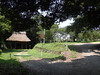
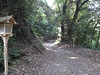
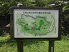
One of "Kōgoishi" hillfort. Although the stone wall was known well, Shinto shrines had been built inside, so the archaeologists misunderstood that the "Kōgoishi" stone wall was built as the boundary of the sacred area. Surrounded area is 2.5 km & 23.6 ha, 2 gate and 4 drain gates were found inside. A parking area and a camping field exists inside.
You may be viewing yesterday's version of this page. To see the most up to date information please register for a free account.
")
")
")
")
Do not use the above information on other web sites or publications without permission of the contributor.
Nearby Images from Flickr
The above images may not be of the site on this page, but were taken nearby. They are loaded from Flickr so please click on them for image credits.
Click here to see more info for this site
Nearby sites
Click here to view sites on an interactive map of the areaKey: Red: member's photo, Blue: 3rd party photo, Yellow: other image, Green: no photo - please go there and take one, Grey: site destroyed
Download sites to:
KML (Google Earth)
GPX (GPS waypoints)
CSV (Garmin/Navman)
CSV (Excel)
To unlock full downloads you need to sign up as a Contributory Member. Otherwise downloads are limited to 50 sites.
Turn off the page maps and other distractions
Nearby sites listing. In the following links * = Image available
23.7km NNE 31° Yōkō-ji temple* Modern Stone Circle etc
23.9km NNE 31° Mekada Family Residence garden* Modern Stone Circle etc
34.6km NW 323° Kan’yō-ji temple* Modern Stone Circle etc
42.6km WNW 282° Mōri Family Residence garden* Modern Stone Circle etc
45.1km WNW 283° Katsura Family Residence garden* Modern Stone Circle etc
55.8km ENE 60° Irifune-yama park* Modern Stone Circle etc
55.9km WNW 295° Jōei-ji temple* Modern Stone Circle etc
55.9km SW 219° JindaiMoji-iwa* Carving
57.7km SW 228° Kiko Resseki* Stone Circle
59.6km NE 43° Hambē restaurant* Modern Stone Circle etc
61.2km WNW 289° Ryūzō-ji temple* Modern Stone Circle etc
62.1km SW 231° Kisaki-no-Yamanokami* Standing Stone (Menhir)
64.3km SW 233° Myōkensha shrine* Stone Circle
65.7km NE 40° Yugama Kofun* Chambered Cairn
66.8km NE 41° Senninzuka Kofun* Chambered Cairn
67.4km SE 141° Semba* Standing Stone (Menhir)
68.1km NE 38° Saiganjiyama Funbogun* Cist
68.2km SE 140° Takayama-Nishinomiya* Standing Stone (Menhir)
68.2km SE 139° Mishima Jinja shrine (in Ehime)* Standing Stone (Menhir)
71.1km SW 228° Anase Yokoana* Rock Cut Tomb
71.8km SE 138° Tomisuyama* Natural Stone / Erratic / Other Natural Feature
72.0km SE 135° Yakaidani* Standing Stone (Menhir)
72.2km SE 140° Awashima Jinja shrine* Natural Stone / Erratic / Other Natural Feature
72.7km W 268° Sōrin-ji temple* Modern Stone Circle etc
73.0km SE 134° Hinaruwa Daba* Natural Stone / Erratic / Other Natural Feature
View more nearby sites and additional images


 We would like to know more about this location. Please feel free to add a brief description and any relevant information in your own language.
 Wir möchten mehr über diese Stätte erfahren. Bitte zögern Sie nicht, eine kurze Beschreibung und relevante Informationen in Deutsch hinzuzufügen.
 Nous aimerions en savoir encore un peu sur les lieux. S'il vous plaît n'hesitez pas à ajouter une courte description et tous les renseignements pertinents dans votre propre langue.
 Quisieramos informarnos un poco más de las lugares. No dude en añadir una breve descripción y otros datos relevantes en su propio idioma.