

<< Our Photo Pages >> Medieval Keep Smrk - Misc. Earthwork in Czech Republic in Bohemia
Submitted by ladrin on Sunday, 12 March 2023 Page Views: 509
Medieval (High and Late)Site Name: Medieval Keep Smrk Alternative Name: Tvrziště SmrkCountry: Czech Republic
NOTE: This site is 4.896 km away from the location you searched for.
Region: Bohemia Type: Misc. Earthwork
Nearest Town: Rakovník Nearest Village: Smrk
Latitude: 50.056678N Longitude: 13.526791E
Condition:
| 5 | Perfect |
| 4 | Almost Perfect |
| 3 | Reasonable but with some damage |
| 2 | Ruined but still recognisable as an ancient site |
| 1 | Pretty much destroyed, possibly visible as crop marks |
| 0 | No data. |
| -1 | Completely destroyed |
| 5 | Superb |
| 4 | Good |
| 3 | Ordinary |
| 2 | Not Good |
| 1 | Awful |
| 0 | No data. |
| 5 | Can be driven to, probably with disabled access |
| 4 | Short walk on a footpath |
| 3 | Requiring a bit more of a walk |
| 2 | A long walk |
| 1 | In the middle of nowhere, a nightmare to find |
| 0 | No data. |
| 5 | co-ordinates taken by GPS or official recorded co-ordinates |
| 4 | co-ordinates scaled from a detailed map |
| 3 | co-ordinates scaled from a bad map |
| 2 | co-ordinates of the nearest village |
| 1 | co-ordinates of the nearest town |
| 0 | no data |
Internal Links:
External Links:
")
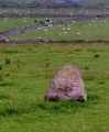
The site is well documented, archaeologically explored somehow and protected by the state. According to sources available it is remains of a medieval fortress from the 13th century. And also a medieval village was located in close vicinity. Fortress and village were destroyed and abandoned allegedly during the Hussite wars in the early 15th century.
Central island has about 20 metres in diameter surrounded by ditch 2,5 m deep. The outer rampart reaches a width up to 15m. Keep is quite a challenge to locate, being situated out of beaten track. Anyway short visit is definitely worth it!
You may be viewing yesterday's version of this page. To see the most up to date information please register for a free account.
")
")
")
")
")
")
Do not use the above information on other web sites or publications without permission of the contributor.
Click here to see more info for this site
Nearby sites
Click here to view sites on an interactive map of the areaKey: Red: member's photo, Blue: 3rd party photo, Yellow: other image, Green: no photo - please go there and take one, Grey: site destroyed
Download sites to:
KML (Google Earth)
GPX (GPS waypoints)
CSV (Garmin/Navman)
CSV (Excel)
To unlock full downloads you need to sign up as a Contributory Member. Otherwise downloads are limited to 50 sites.
Turn off the page maps and other distractions
Nearby sites listing. In the following links * = Image available
2.8km N 4° God's Stone Soseň* Natural Stone / Erratic / Other Natural Feature
5.5km NW 314° Jesenice Cross Stone* Ancient Cross
6.0km NW 320° Jesenice Propitiatory Crosses* Ancient Cross
6.3km WNW 297° Petrified Heart* Natural Stone / Erratic / Other Natural Feature
7.4km WNW 296° Krty Devil's Stone* Natural Stone / Erratic / Other Natural Feature
9.8km NW 314° Stebno Stone Cross* Ancient Cross
10.9km W 263° Zihle Rocks* Natural Stone / Erratic / Other Natural Feature
12.3km W 270° Dědek* Natural Stone / Erratic / Other Natural Feature
12.3km W 271° Bába* Natural Stone / Erratic / Other Natural Feature
13.5km W 271° Logan Stones* Natural Stone / Erratic / Other Natural Feature
14.4km W 273° Rock Town* Natural Stone / Erratic / Other Natural Feature
15.7km ENE 64° Viereckschanze Na Kokrdech* Misc. Earthwork
16.2km ENE 65° Rakovník Menhir* Standing Stone (Menhir)
16.6km W 266° Rabštejn propitiatory cross* Ancient Cross
20.4km NNE 32° Kounov maze* Modern Stone Circle etc
21.5km NNE 24° Něčemice stone alignment II* Stone Row / Alignment
21.8km NNE 31° St. Vojtech Holy Well* Holy Well or Sacred Spring
21.9km NNE 27° Menhir Belgičan (Belgian)* Standing Stone (Menhir)
22.1km NNE 28° Vizír Stones* Standing Stones
22.1km NNE 27° Špičák 14* Standing Stone (Menhir)
22.1km NNE 28° Kámen Chodník (Footway stone)* Standing Stone (Menhir)
22.1km NNE 27° Špičák 15* Stone Row / Alignment
22.3km NNE 28° Galeje* Standing Stones
22.3km NNE 33° Kounov Alignments* Stone Row / Alignment
22.3km W 281° Protivec Propitiatory Cross 1* Ancient Cross
View more nearby sites and additional images


 We would like to know more about this location. Please feel free to add a brief description and any relevant information in your own language.
 Wir möchten mehr über diese Stätte erfahren. Bitte zögern Sie nicht, eine kurze Beschreibung und relevante Informationen in Deutsch hinzuzufügen.
 Nous aimerions en savoir encore un peu sur les lieux. S'il vous plaît n'hesitez pas à ajouter une courte description et tous les renseignements pertinents dans votre propre langue.
 Quisieramos informarnos un poco más de las lugares. No dude en añadir una breve descripción y otros datos relevantes en su propio idioma.