<< Our Photo Pages >> Oea. - Ancient Village or Settlement in Libya
Submitted by AlexHunger on Wednesday, 16 April 2008 Page Views: 4685
Multi-periodSite Name: Oea.Country: Libya
NOTE: This site is 133.151 km away from the location you searched for.
Type: Ancient Village or Settlement
Nearest Town: Tripoli Nearest Village: Tripoli
Latitude: 32.899885N Longitude: 13.175880E
Condition:
| 5 | Perfect |
| 4 | Almost Perfect |
| 3 | Reasonable but with some damage |
| 2 | Ruined but still recognisable as an ancient site |
| 1 | Pretty much destroyed, possibly visible as crop marks |
| 0 | No data. |
| -1 | Completely destroyed |
| 5 | Superb |
| 4 | Good |
| 3 | Ordinary |
| 2 | Not Good |
| 1 | Awful |
| 0 | No data. |
| 5 | Can be driven to, probably with disabled access |
| 4 | Short walk on a footpath |
| 3 | Requiring a bit more of a walk |
| 2 | A long walk |
| 1 | In the middle of nowhere, a nightmare to find |
| 0 | No data. |
| 5 | co-ordinates taken by GPS or official recorded co-ordinates |
| 4 | co-ordinates scaled from a detailed map |
| 3 | co-ordinates scaled from a bad map |
| 2 | co-ordinates of the nearest village |
| 1 | co-ordinates of the nearest town |
| 0 | no data |
Internal Links:
External Links:
")
Oea was founded by the Phoenician in the 7th century BCE. Oea came under the control of Carthaginians after the Assyrians conquered Phoenecia. The Numidians took it after the Punic empire crumbled in 162 BCE and the Romans took it from them in 46 BCE.
The vandals captured it in 450 CE but the Byzantines took it back in 533 CE. After 645 CE, the population of Oea, nearby Leptis Magna and Sabratha was consolidated here, which led to the name Tripoli (three towns).
The location is given for the arch of Marcus Aurelius. There is also a plynth of a Roman temple nearby, but most of the antike remains are buried under the modern city. See nearby national museum for other relics.
You may be viewing yesterday's version of this page. To see the most up to date information please register for a free account.
Do not use the above information on other web sites or publications without permission of the contributor.
Nearby Images from Flickr


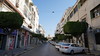
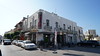
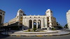
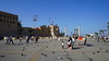
The above images may not be of the site on this page, but were taken nearby. They are loaded from Flickr so please click on them for image credits.
Click here to see more info for this site
Nearby sites
Click here to view sites on an interactive map of the areaKey: Red: member's photo, Blue: 3rd party photo, Yellow: other image, Green: no photo - please go there and take one, Grey: site destroyed
Download sites to:
KML (Google Earth)
GPX (GPS waypoints)
CSV (Garmin/Navman)
CSV (Excel)
To unlock full downloads you need to sign up as a Contributory Member. Otherwise downloads are limited to 50 sites.
Turn off the page maps and other distractions
Nearby sites listing. In the following links * = Image available
637m SE 136° Tripoli National Museum Museum
65.0km SE 139° Tarhuna Rock Art* Rock Art
65.4km W 261° Sabratha Ancient Village or Settlement
108.1km ESE 106° Leptis Magna Museum* Museum
108.4km ESE 105° Leptis Magna* Ancient Village or Settlement
127.5km ESE 111° Suq al Jumah Mausoleum Portal Tomb
295.9km N 349° Lampedusa* Ancient Village or Settlement
301.4km NW 311° Thaenae Ancient Village or Settlement
301.9km NW 313° Municipalité de Sfax Musee Museum
305.3km WNW 292° Gabes Archeology Museum Museum
345.4km NNE 19° Mnajdra* Ancient Temple
345.6km NNE 19° Misqa Tanks* NOT SET
345.7km NNE 19° Hagar Qim* Ancient Temple
345.9km NNE 19° Wardija Ta'San Ġorġ* Ancient Village or Settlement
346.0km NNE 19° Wardija Ta'San Gorg* Ancient Trackway
346.1km NNE 20° Wied Znuber* Burial Chamber or Dolmen
346.5km NNE 18° Kappella ta' Santa Marija Maddalena Cart Ruts* Ancient Trackway
346.7km NNE 19° Għar Mundu Cart Ruts* Ancient Trackway
346.7km NNE 18° Ghar il-Kbir* Cave or Rock Shelter
346.8km NNE 19° Ghar il-Kbir Shaft Tomb III* Rock Cut Tomb
346.8km NNE 19° Ghar il-Kbir Shaft Tomb II* Rock Cut Tomb
346.8km NNE 19° Ghar il-Kbir Shaft Tomb I* Rock Cut Tomb
346.9km NNE 19° Clapham Junction Cart Ruts* Ancient Trackway
347.4km NNE 19° Misrah is-Sinjura* Burial Chamber or Dolmen
348.5km NNE 18° Għar Ilma Cart Ruts* Ancient Trackway
View more nearby sites and additional images


 We would like to know more about this location. Please feel free to add a brief description and any relevant information in your own language.
 Wir möchten mehr über diese Stätte erfahren. Bitte zögern Sie nicht, eine kurze Beschreibung und relevante Informationen in Deutsch hinzuzufügen.
 Nous aimerions en savoir encore un peu sur les lieux. S'il vous plaît n'hesitez pas à ajouter une courte description et tous les renseignements pertinents dans votre propre langue.
 Quisieramos informarnos un poco más de las lugares. No dude en añadir una breve descripción y otros datos relevantes en su propio idioma.