<< Our Photo Pages >> Dalen Gravfelt - Standing Stone (Menhir) in Norway in Nordland
Submitted by kenntha88 on Monday, 19 October 2009 Page Views: 2399
Neolithic and Bronze AgeSite Name: Dalen Gravfelt Alternative Name: ReipåCountry: Norway
NOTE: This site is 2.867 km away from the location you searched for.
Fylke: Nordland Type: Standing Stone (Menhir)
Nearest Town: Bodø Nearest Village: Ørnes
Latitude: 66.929989N Longitude: 13.611374E
Condition:
| 5 | Perfect |
| 4 | Almost Perfect |
| 3 | Reasonable but with some damage |
| 2 | Ruined but still recognisable as an ancient site |
| 1 | Pretty much destroyed, possibly visible as crop marks |
| 0 | No data. |
| -1 | Completely destroyed |
| 5 | Superb |
| 4 | Good |
| 3 | Ordinary |
| 2 | Not Good |
| 1 | Awful |
| 0 | No data. |
| 5 | Can be driven to, probably with disabled access |
| 4 | Short walk on a footpath |
| 3 | Requiring a bit more of a walk |
| 2 | A long walk |
| 1 | In the middle of nowhere, a nightmare to find |
| 0 | No data. |
| 5 | co-ordinates taken by GPS or official recorded co-ordinates |
| 4 | co-ordinates scaled from a detailed map |
| 3 | co-ordinates scaled from a bad map |
| 2 | co-ordinates of the nearest village |
| 1 | co-ordinates of the nearest town |
| 0 | no data |
Internal Links:
External Links:
")
This beautiful standing stone is situated in a small valley running north-west to south-east between two very steep mountain sides. This wonderful landscape adds to sites great ambience. It is next to the coastal highway running from Bodø to Steinkjer, which is a very popular route for tourists visiting Norway.
The stone is about 3 metres tall, about 70cm broad and just 10cm wide, making it a slender appearance. It is still standing straight and does not tilt to any side. It is located on top of a small burial mound, three more low burial mounds are known to have been in the area around the stone, but have later been destroyed during the construction of the highway and some nearby houses.
You may be viewing yesterday's version of this page. To see the most up to date information please register for a free account.
")
")
")
Do not use the above information on other web sites or publications without permission of the contributor.
Nearby Images from Flickr

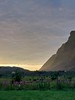

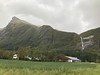

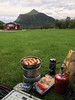
The above images may not be of the site on this page, but were taken nearby. They are loaded from Flickr so please click on them for image credits.
Click here to see more info for this site
Nearby sites
Click here to view sites on an interactive map of the areaKey: Red: member's photo, Blue: 3rd party photo, Yellow: other image, Green: no photo - please go there and take one, Grey: site destroyed
Download sites to:
KML (Google Earth)
GPX (GPS waypoints)
CSV (Garmin/Navman)
CSV (Excel)
To unlock full downloads you need to sign up as a Contributory Member. Otherwise downloads are limited to 50 sites.
Turn off the page maps and other distractions
Nearby sites listing. In the following links * = Image available
10.9km SSE 152° Eidbukta Cemetery* Barrow Cemetery
16.2km SSW 198° Nedre Vall Standing Stone* Standing Stone (Menhir)
18.4km SSW 202° Åmøy Carvings* Carving
23.1km SE 131° Fykan Carvings* Carving
47.2km ENE 60° Øvre Kvikstad* Standing Stone (Menhir)
51.4km NE 40° Nordland Museum, Bodø* Museum
51.7km NE 40° Bodø Standing Stone* Standing Stone (Menhir)
53.8km NE 42° Vågøynes monument* Standing Stones
53.8km NE 53° Tuv Storåsen* Standing Stones
53.9km NE 41° Opplia* Standing Stone (Menhir)
55.7km NE 52° Saltstraumen* Barrow Cemetery
57.8km NE 47° Fenes* Standing Stone (Menhir)
60.9km NE 52° Godøynes* Barrow Cemetery
66.8km ENE 60° Kvistadvika settlement* Ancient Village or Settlement
69.4km ENE 60° Ljønes burial site* Barrow Cemetery
72.6km NE 55° Mjønes burial site* Barrow Cemetery
84.6km ENE 66° Leivset sacrificial site* Natural Stone / Erratic / Other Natural Feature
85.8km ESE 117° Stødi sacrificial site* Natural Stone / Erratic / Other Natural Feature
96.4km SSW 207° Gleinsneset Cemetery* Barrow Cemetery
96.7km SSW 208° Valhaugen* Round Barrow(s)
104.7km NE 54° Daumannvikflåget* Natural Stone / Erratic / Other Natural Feature
125.7km NNE 27° Hagbardsholmen Island burial field* Barrow Cemetery
125.8km NNE 28° Gjerdet* Round Barrow(s)
125.9km NNE 27° Langsteinen* Standing Stone (Menhir)
127.0km NNE 29° Sandvågen altar* Carving
View more nearby sites and additional images


 We would like to know more about this location. Please feel free to add a brief description and any relevant information in your own language.
 Wir möchten mehr über diese Stätte erfahren. Bitte zögern Sie nicht, eine kurze Beschreibung und relevante Informationen in Deutsch hinzuzufügen.
 Nous aimerions en savoir encore un peu sur les lieux. S'il vous plaît n'hesitez pas à ajouter une courte description et tous les renseignements pertinents dans votre propre langue.
 Quisieramos informarnos un poco más de las lugares. No dude en añadir una breve descripción y otros datos relevantes en su propio idioma.