

<< Our Photo Pages >> Ridderhaugen - Round Barrow(s) in Norway in Akershus
Submitted by kenntha88 on Saturday, 06 October 2012 Page Views: 1812
Neolithic and Bronze AgeSite Name: Ridderhaugen Alternative Name: The Knights moundCountry: Norway
NOTE: This site is 8.465 km away from the location you searched for.
Fylke: Akershus Type: Round Barrow(s)
Nearest Town: Lillestrøm Nearest Village: Fetsund
Latitude: 59.915717N Longitude: 11.169791E
Condition:
| 5 | Perfect |
| 4 | Almost Perfect |
| 3 | Reasonable but with some damage |
| 2 | Ruined but still recognisable as an ancient site |
| 1 | Pretty much destroyed, possibly visible as crop marks |
| 0 | No data. |
| -1 | Completely destroyed |
| 5 | Superb |
| 4 | Good |
| 3 | Ordinary |
| 2 | Not Good |
| 1 | Awful |
| 0 | No data. |
| 5 | Can be driven to, probably with disabled access |
| 4 | Short walk on a footpath |
| 3 | Requiring a bit more of a walk |
| 2 | A long walk |
| 1 | In the middle of nowhere, a nightmare to find |
| 0 | No data. |
| 5 | co-ordinates taken by GPS or official recorded co-ordinates |
| 4 | co-ordinates scaled from a detailed map |
| 3 | co-ordinates scaled from a bad map |
| 2 | co-ordinates of the nearest village |
| 1 | co-ordinates of the nearest town |
| 0 | no data |
Internal Links:
External Links:
")
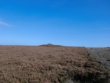
In the schoolyard of Sand School in Fet is one of Akershus' more impressive tombs. The barrow is a round barrow made of earth and is overgrown with grass and some trees. It is called "Ridderhaugen" or "The Knight's Mound".
The massive round barrow is almost 40 metres in diameter and around 5 metres in height.
The flattened top also bears traces of looting of ancient times, with a crater measuring 11m x 9m and is 1.5m in depth.
The barrow is located on a hill with great views down to Øyeren. The barrow is also only 200m from the Fet church. The church that stands today was built in the late 1800's but since the Middle Ages there has been a church on this site. It is thus interesting to see the mound in relation to early Christianity.
You may be viewing yesterday's version of this page. To see the most up to date information please register for a free account.
")
")
Do not use the above information on other web sites or publications without permission of the contributor.
Nearby Images from Flickr


The above images may not be of the site on this page, but were taken nearby. They are loaded from Flickr so please click on them for image credits.
Click here to see more info for this site
Nearby sites
Click here to view sites on an interactive map of the areaKey: Red: member's photo, Blue: 3rd party photo, Yellow: other image, Green: no photo - please go there and take one, Grey: site destroyed
Download sites to:
KML (Google Earth)
GPX (GPS waypoints)
CSV (Garmin/Navman)
CSV (Excel)
To unlock full downloads you need to sign up as a Contributory Member. Otherwise downloads are limited to 50 sites.
Turn off the page maps and other distractions
Nearby sites listing. In the following links * = Image available
2.5km NNE 33° Guriholtet barrow cemetery* Barrow Cemetery
6.7km SE 145° Tølleren Gan* Barrow Cemetery
8.4km NNW 334° Asak Cemetery* Barrow Cemetery
9.6km NNE 29° Bingsfossen Helleristninger* Rock Art
10.1km ENE 61° Jødal Lille* Barrow Cemetery
10.9km NNE 22° Valsmoen* Barrow Cemetery
11.0km NW 322° Skedsmo Kirke Phallitic Stone* Standing Stone (Menhir)
11.4km NW 322° Sten-Tærud* Barrow Cemetery
12.4km NE 41° Lille Huseby og Kjempehaugen* Round Barrow(s)
12.6km NE 42° Hellerudåsen cemetery* Barrow Cemetery
16.3km N 349° Brotnuhaugen-Snilehaugen* Round Barrow(s)
21.2km NNW 348° Torshov* Barrow Cemetery
22.4km W 267° St. Olav`s Way Oslo* Marker Stone
22.5km W 265° Ekeberg Bronze Age Carvings* Rock Art
22.5km W 264° Ekeberg Stone Settings* Stone Circle
22.7km W 267° Kongsgaarden* Ancient Palace
22.9km W 265° Ekeberg Rock Art* Rock Art
23.8km N 8° Åssand* Round Barrow(s)
24.2km W 270° Oslo Historical Museum* Museum
24.3km N 7° Skinnfellbråtan* Barrow Cemetery
24.4km N 6° Bekkedalsgutua* Round Barrow(s)
24.6km N 10° Fonbekkhagan* Barrow Cemetery
25.4km N 354° The Prince's Mound* Round Barrow(s)
25.8km N 356° Rakni's Mound* Round Barrow(s)
25.8km N 355° Hertelshaugen* Round Barrow(s)
View more nearby sites and additional images


 We would like to know more about this location. Please feel free to add a brief description and any relevant information in your own language.
 Wir möchten mehr über diese Stätte erfahren. Bitte zögern Sie nicht, eine kurze Beschreibung und relevante Informationen in Deutsch hinzuzufügen.
 Nous aimerions en savoir encore un peu sur les lieux. S'il vous plaît n'hesitez pas à ajouter une courte description et tous les renseignements pertinents dans votre propre langue.
 Quisieramos informarnos un poco más de las lugares. No dude en añadir una breve descripción y otros datos relevantes en su propio idioma.