<< Our Photo Pages >> Untere Grübelplatte (Schalenstein) - Rock Art in Italy in Trentino-Alto Adige
Submitted by MaRe on Friday, 02 December 2016 Page Views: 2023
Rock ArtSite Name: Untere Grübelplatte (Schalenstein) Alternative Name: Untergrübelplatte, Untere Griabeleplott, UntergrüblplatteCountry: Italy
NOTE: This site is 19.888 km away from the location you searched for.
Region: Trentino-Alto Adige Type: Rock Art
Nearest Town: Meran Nearest Village: Latsch
Latitude: 46.626650N Longitude: 10.879083E
Condition:
| 5 | Perfect |
| 4 | Almost Perfect |
| 3 | Reasonable but with some damage |
| 2 | Ruined but still recognisable as an ancient site |
| 1 | Pretty much destroyed, possibly visible as crop marks |
| 0 | No data. |
| -1 | Completely destroyed |
| 5 | Superb |
| 4 | Good |
| 3 | Ordinary |
| 2 | Not Good |
| 1 | Awful |
| 0 | No data. |
| 5 | Can be driven to, probably with disabled access |
| 4 | Short walk on a footpath |
| 3 | Requiring a bit more of a walk |
| 2 | A long walk |
| 1 | In the middle of nowhere, a nightmare to find |
| 0 | No data. |
| 5 | co-ordinates taken by GPS or official recorded co-ordinates |
| 4 | co-ordinates scaled from a detailed map |
| 3 | co-ordinates scaled from a bad map |
| 2 | co-ordinates of the nearest village |
| 1 | co-ordinates of the nearest town |
| 0 | no data |
Internal Links:
External Links:
 (PID:160102)")
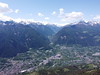
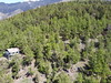
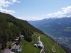
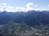
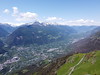
Prehistoric site with a big rock with 173 cupmarks, different lines and an astronomically oriented cross. It is one of the most beautiful pieces of rock art of the Vinschgau valley. Situated at an altitude of 940m on the "sun"-mountain (Sonnenberg) between Latsch and Kastelbell (ital.: Laces and Castelbello) it is one of more than 50 stones with cup-marks. Some meters above the Grübelplatte there are other cups on a vertical rock. There are no archaeological finds from this site, the age of the cups should be at least from the Bronze Age.
German: Die Untere Grübelplatte ist einer der schönsten Schalensteine im Vinschgau. Am Hang des Sonnenberg über der Latschander gelegen bietet sich von ihrem Standort ein Panoramablick über das Tal zwischen Kastelbell und Latsch auf eine beeindruckende Bergwelt. Insgesamt befinden sich etwa 50 Schalensteine am Sonnenberg zwischen Tschars und Goldrain, wobei dieser mit 173 Schälchen unterschiedlicher Größen, teilweise Verbindungslinien und einem astronomisch ausgerichteten Kreuz sicherlich einer der Beeindruckendsten ist. Etwas oberhalb der Grübelplatte ist ein weiterer Schalenstein zu erkennen, der vertikal aus der Erde ragt. Zu der Seite gibt es keine archäologischen Erkenntnisse bzw. keine Ausgrabung und bekannte Funde.
You may be viewing yesterday's version of this page. To see the most up to date information please register for a free account.
 (PID:160104)")
 (PID:160103)")
 (PID:160105)")
Do not use the above information on other web sites or publications without permission of the contributor.
Nearby Images from Flickr

The above images may not be of the site on this page, but were taken nearby. They are loaded from Flickr so please click on them for image credits.
Click here to see more info for this site
Nearby sites
Click here to view sites on an interactive map of the areaKey: Red: member's photo, Blue: 3rd party photo, Yellow: other image, Green: no photo - please go there and take one, Grey: site destroyed
Download sites to:
KML (Google Earth)
GPX (GPS waypoints)
CSV (Garmin/Navman)
CSV (Excel)
To unlock full downloads you need to sign up as a Contributory Member. Otherwise downloads are limited to 50 sites.
Turn off the page maps and other distractions
Nearby sites listing. In the following links * = Image available
11.0km N 351° ArcheoPark and Museum Val Senales* Museum
17.2km N 350° Ötzi Memorial* Marker Stone
19.7km ENE 73° Stone Age 2001* Modern Stone Circle etc
20.5km ENE 57° Spronser Seen (Sprons Lakes)* Rock Art
22.9km N 6° Kaser Menhir Standing Stone (Menhir)
25.1km N 6° Hohler Stein Kaser Natural Stone / Erratic / Other Natural Feature
26.4km N 8° Mutsbichl Schalensteine Rock Art
32.3km NNE 13° Heiligkreuz Teufelsfelsen Rock Art
34.5km NNE 20° Lenzenalm Schalenstein Rock Art
38.6km ESE 111° South Tyrol Museum of Archaeology* Museum
39.0km NNE 15° Schlangenfelsen (Snake's rock) Rock Art
39.4km NNE 15° Sölden menhir* Standing Stone (Menhir)
39.7km NNE 18° Windachtal Schalenstein I Rock Art
40.1km NNE 28° Windachtal Schalenstein II Rock Art
43.7km ESE 105° Der Menhir von Wolfsgruben* Standing Stone (Menhir)
48.6km N 8° Burgstein Schalenstein Rock Art
50.1km N 4° Innerbergalm Schalenstein Rock Art
52.6km NNW 342° Schalenstein Prutz Rock Art
53.3km WNW 303° Heidelberg Hut Ancient Village or Settlement
54.4km ESE 103° Schlern Natural Stone / Erratic / Other Natural Feature
56.3km N 4° Ötzi Village* Museum
60.0km SW 232° Rupe Magna* Rock Art
61.2km E 79° Bildstein (Elvas)* Rock Art
62.3km NNE 29° Cupstone Lithagrub-Profegl Alm* Rock Art
63.2km N 359° Sautens Opferstein Natural Stone / Erratic / Other Natural Feature
View more nearby sites and additional images


 We would like to know more about this location. Please feel free to add a brief description and any relevant information in your own language.
 Wir möchten mehr über diese Stätte erfahren. Bitte zögern Sie nicht, eine kurze Beschreibung und relevante Informationen in Deutsch hinzuzufügen.
 Nous aimerions en savoir encore un peu sur les lieux. S'il vous plaît n'hesitez pas à ajouter une courte description et tous les renseignements pertinents dans votre propre langue.
 Quisieramos informarnos un poco más de las lugares. No dude en añadir una breve descripción y otros datos relevantes en su propio idioma.