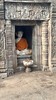
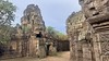
<< Our Photo Pages >> Wat Nokor - Ancient Temple in Cambodia
Submitted by AlexHunger on Saturday, 02 October 2010 Page Views: 7457
Multi-periodSite Name: Wat NokorCountry: Cambodia Type: Ancient Temple
Nearest Town: Kampong Cham Nearest Village: Kampong Cham
Latitude: 11.997682N Longitude: 105.448837E
Condition:
| 5 | Perfect |
| 4 | Almost Perfect |
| 3 | Reasonable but with some damage |
| 2 | Ruined but still recognisable as an ancient site |
| 1 | Pretty much destroyed, possibly visible as crop marks |
| 0 | No data. |
| -1 | Completely destroyed |
| 5 | Superb |
| 4 | Good |
| 3 | Ordinary |
| 2 | Not Good |
| 1 | Awful |
| 0 | No data. |
| 5 | Can be driven to, probably with disabled access |
| 4 | Short walk on a footpath |
| 3 | Requiring a bit more of a walk |
| 2 | A long walk |
| 1 | In the middle of nowhere, a nightmare to find |
| 0 | No data. |
| 5 | co-ordinates taken by GPS or official recorded co-ordinates |
| 4 | co-ordinates scaled from a detailed map |
| 3 | co-ordinates scaled from a bad map |
| 2 | co-ordinates of the nearest village |
| 1 | co-ordinates of the nearest town |
| 0 | no data |
Internal Links:
External Links:
")
Ancient Khmer Temple west of Kampong Cham
You may be viewing yesterday's version of this page. To see the most up to date information please register for a free account.
Do not use the above information on other web sites or publications without permission of the contributor.
Nearby Images from Flickr
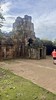
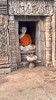
The above images may not be of the site on this page, but were taken nearby. They are loaded from Flickr so please click on them for image credits.
Click here to see more info for this site
Nearby sites
Click here to view sites on an interactive map of the areaKey: Red: member's photo, Blue: 3rd party photo, Yellow: other image, Green: no photo - please go there and take one, Grey: site destroyed
Download sites to:
KML (Google Earth)
GPX (GPS waypoints)
CSV (Garmin/Navman)
CSV (Excel)
To unlock full downloads you need to sign up as a Contributory Member. Otherwise downloads are limited to 50 sites.
Turn off the page maps and other distractions
Nearby sites listing. In the following links * = Image available
74.2km SW 230° National Museum of Cambodia* Museum
100.8km NW 323° Sambor Preah Kuk* Ancient Temple
174.3km NNW 334° Preah Khan Kampong Svay Ancient Temple
198.0km SW 221° Phnom Chhngok Cave Temple Cave or Rock Shelter
211.0km NW 321° Beng Mealea Ancient Temple
211.5km SE 144° Rach Nui* Artificial Mound
217.0km NW 312° Prasat Trapeang Phong Ancient Temple
218.1km NW 312° Prasat Totoeng Thngai Ancient Temple
218.3km NW 313° Prasat Prei Monti* Ancient Temple
218.5km NW 313° Bakong* Ancient Temple
219.2km NW 313° Preah Ko* Ancient Temple
219.8km NW 313° Lolei* Ancient Temple
221.0km NW 316° Chau Srei Vibol* Ancient Temple
222.0km NNW 334° Koh Ker* Ancient Village or Settlement
227.8km NW 315° Banteay Samré* Ancient Temple
228.0km NW 316° Phnom Bok* Ancient Temple
228.1km NW 309° Phnom Krom* Ancient Temple
228.4km NW 310° Wat Athvea* Ancient Temple
230.0km NW 312° Angkor National Museum* Museum
230.2km NW 314° Prasat Leak Neang* Ancient Temple
230.3km NW 314° Pre Rup* Ancient Temple
230.5km NW 314° Bat Chum* Ancient Temple
230.7km NW 313° Prasat Kravan* Ancient Temple
231.2km NW 314° East Mebon* Ancient Temple
231.3km NW 314° Srah Srang* Ancient Temple
View more nearby sites and additional images


 We would like to know more about this location. Please feel free to add a brief description and any relevant information in your own language.
 Wir möchten mehr über diese Stätte erfahren. Bitte zögern Sie nicht, eine kurze Beschreibung und relevante Informationen in Deutsch hinzuzufügen.
 Nous aimerions en savoir encore un peu sur les lieux. S'il vous plaît n'hesitez pas à ajouter une courte description et tous les renseignements pertinents dans votre propre langue.
 Quisieramos informarnos un poco más de las lugares. No dude en añadir una breve descripción y otros datos relevantes en su propio idioma.