

<< Other Photo Pages >> Hang Con Moong - Cave or Rock Shelter in Vietnam
Submitted by bat400 on Saturday, 16 November 2013 Page Views: 4944
Natural PlacesSite Name: Hang Con Moong Alternative Name: Con Moong CaveCountry: Vietnam
NOTE: This site is 25.504 km away from the location you searched for.
Type: Cave or Rock Shelter
Latitude: 20.317000N Longitude: 105.608000E
Condition:
| 5 | Perfect |
| 4 | Almost Perfect |
| 3 | Reasonable but with some damage |
| 2 | Ruined but still recognisable as an ancient site |
| 1 | Pretty much destroyed, possibly visible as crop marks |
| 0 | No data. |
| -1 | Completely destroyed |
| 5 | Superb |
| 4 | Good |
| 3 | Ordinary |
| 2 | Not Good |
| 1 | Awful |
| 0 | No data. |
| 5 | Can be driven to, probably with disabled access |
| 4 | Short walk on a footpath |
| 3 | Requiring a bit more of a walk |
| 2 | A long walk |
| 1 | In the middle of nowhere, a nightmare to find |
| 0 | No data. |
| 5 | co-ordinates taken by GPS or official recorded co-ordinates |
| 4 | co-ordinates scaled from a detailed map |
| 3 | co-ordinates scaled from a bad map |
| 2 | co-ordinates of the nearest village |
| 1 | co-ordinates of the nearest town |
| 0 | no data |
Be the first person to rate this site - see the 'Contribute!' box in the right hand menu.
Internal Links:
External Links:
")
It has been confirmed that the continuation of art techniques to make cobble tools with representatives from Sơn Vi culture [Palaeolithic] to Hòa Bình culture [Mesolithic,] and then Bắc Sơn culture [Neolithic (10,000-8,000 BC).] Con Moong Cave may show the evolution of human beings ... from hunting and gathering, to [plant and animal domestication.] - summation from Wikipedia.
Lies within the Cúc Phương National Park.
Note: Vietnamese archaeologists found tons of shells and tools and the remains of burials dating back more than ten thousand of year
You may be viewing yesterday's version of this page. To see the most up to date information please register for a free account.
Do not use the above information on other web sites or publications without permission of the contributor.
Nearby Images from Flickr


The above images may not be of the site on this page, but were taken nearby. They are loaded from Flickr so please click on them for image credits.
Click here to see more info for this site
Nearby sites
Click here to view sites on an interactive map of the areaKey: Red: member's photo, Blue: 3rd party photo, Yellow: other image, Green: no photo - please go there and take one, Grey: site destroyed
Download sites to:
KML (Google Earth)
GPX (GPS waypoints)
CSV (Garmin/Navman)
CSV (Excel)
To unlock full downloads you need to sign up as a Contributory Member. Otherwise downloads are limited to 50 sites.
Turn off the page maps and other distractions
Nearby sites listing. In the following links * = Image available
82.9km NNE 18° Vietnam National Museum of History Museum
83.5km NNE 17° Dong Anh metal age furnaces Ancient Mine, Quarry or other Industry
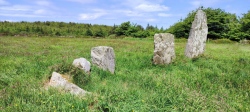
161.0km W 274° Hintang Archaeological Park* Standing Stones
235.2km N 353° Tham Choong Cave Cave or Rock Shelter
258.7km WSW 245° The Plain of Jars* Ancient Mine, Quarry or other Industry
418.6km SSW 199° Phu Pha Yol Rock Engravings Rock Art
446.6km SW 230° Phu Phra Bat Historical Park Rock Art
546.9km S 181° Pha Taem Rock Art Rock Art
599.6km SSE 154° Mỹ Sơn* Ancient Temple
630.5km S 176° Wat Phou* Ancient Village or Settlement
639.2km WSW 253° San Chao Pho Pratu Pha Rock Art
662.8km SSW 213° Ban Non Wat Ancient Village or Settlement
665.7km S 189° Prasat Preah Vihear* Ancient Temple
735.5km S 189° Koh Ker* Ancient Village or Settlement
742.6km WSW 241° Sukothai* Ancient Village or Settlement
743.8km SSW 201° Banteay Chhmar Ancient Temple
756.5km SSW 193° Kbal Spean* Carving
767.2km SSW 193° Banteay Srei* Ancient Temple
773.7km S 187° Preah Khan Kampong Svay Ancient Temple
774.8km S 191° Beng Mealea Ancient Temple
781.2km SSW 193° Phnom Bok* Ancient Temple
783.0km SSW 194° Ta Som* Ancient Temple
783.1km SSW 194° Krol Ko* Ancient Temple
783.4km SSW 194° Banteay Prei* Ancient Temple
783.5km SSW 194° Prasat Prei* Ancient Temple
View more nearby sites and additional images


 We would like to know more about this location. Please feel free to add a brief description and any relevant information in your own language.
 Wir möchten mehr über diese Stätte erfahren. Bitte zögern Sie nicht, eine kurze Beschreibung und relevante Informationen in Deutsch hinzuzufügen.
 Nous aimerions en savoir encore un peu sur les lieux. S'il vous plaît n'hesitez pas à ajouter une courte description et tous les renseignements pertinents dans votre propre langue.
 Quisieramos informarnos un poco más de las lugares. No dude en añadir una breve descripción y otros datos relevantes en su propio idioma.