 with our Megalithic Portal iPhone app")


<< Our Photo Pages >> St. Olav`s Way Oslo - Marker Stone in Norway in Oslo
Submitted by Harald_Platta on Wednesday, 25 March 2020 Page Views: 822
Multi-periodSite Name: St. Olav`s Way Oslo Alternative Name: GudbrandsdalsledenCountry: Norway
NOTE: This site is 4.014 km away from the location you searched for.
Fylke: Oslo Type: Marker Stone
Nearest Town: Oalo
Latitude: 59.906039N Longitude: 10.768161E
Condition:
| 5 | Perfect |
| 4 | Almost Perfect |
| 3 | Reasonable but with some damage |
| 2 | Ruined but still recognisable as an ancient site |
| 1 | Pretty much destroyed, possibly visible as crop marks |
| 0 | No data. |
| -1 | Completely destroyed |
| 5 | Superb |
| 4 | Good |
| 3 | Ordinary |
| 2 | Not Good |
| 1 | Awful |
| 0 | No data. |
| 5 | Can be driven to, probably with disabled access |
| 4 | Short walk on a footpath |
| 3 | Requiring a bit more of a walk |
| 2 | A long walk |
| 1 | In the middle of nowhere, a nightmare to find |
| 0 | No data. |
| 5 | co-ordinates taken by GPS or official recorded co-ordinates |
| 4 | co-ordinates scaled from a detailed map |
| 3 | co-ordinates scaled from a bad map |
| 2 | co-ordinates of the nearest village |
| 1 | co-ordinates of the nearest town |
| 0 | no data |
Internal Links:
External Links:
I have visited· I would like to visit
Harald_Platta visited on 15th Sep 2010 - their rating: Cond: 5 Amb: 4 Access: 5
")
The pilgrim road was already an important trading and travelling route in the Iron Age.
References:
[01] Raju, A.:The Pilgrim Road to Trondheim: Oslo to Nidaros Cathedral (Trondheim: Museumsforlaget) / (2015).
[02] Luthen, E.: I pilegrimenes fotspor til Nidaros (Oslo: Cappelen) /(1992).
[03] Kollandsrud, M.: Pilgrimsleden til Nidaros (Oslo: Gyldendal) / (1997).
[04] Knut, I.: Pilegrimsgang til Nidaros (Oslo: Gyldendal Tiden) / (1992).
[05] Söderlund, S.: Marie Sjöström (2016).
You may be viewing yesterday's version of this page. To see the most up to date information please register for a free account.
Do not use the above information on other web sites or publications without permission of the contributor.
Nearby Images from Flickr


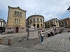
The above images may not be of the site on this page, but were taken nearby. They are loaded from Flickr so please click on them for image credits.
Click here to see more info for this site
Nearby sites
Click here to view sites on an interactive map of the areaKey: Red: member's photo, Blue: 3rd party photo, Yellow: other image, Green: no photo - please go there and take one, Grey: site destroyed
Download sites to:
KML (Google Earth)
GPX (GPS waypoints)
CSV (Garmin/Navman)
CSV (Excel)
To unlock full downloads you need to sign up as a Contributory Member. Otherwise downloads are limited to 50 sites.
Turn off the page maps and other distractions
Nearby sites listing. In the following links * = Image available
393m SW 225° Kongsgaarden* Ancient Palace
1.1km SSW 205° Ekeberg Rock Art* Rock Art
1.1km S 178° Ekeberg Bronze Age Carvings* Rock Art
1.2km S 178° Ekeberg Stone Settings* Stone Circle
2.2km WNW 304° Oslo Historical Museum* Museum
4.6km W 268° Oslo Ship Museum* Museum
13.2km W 279° Dalbo Helleristninger* Rock Art
16.2km W 267° Tanumplatået* Barrow Cemetery
18.3km ENE 57° Sten-Tærud* Barrow Cemetery
18.4km ENE 58° Skedsmo Kirke Phallitic Stone* Standing Stone (Menhir)
19.7km WSW 249° Asker Barrows* Barrow Cemetery
20.4km S 179° Nordby-Østre* Barrow Cemetery
20.5km SSE 168° Vardehaug* Barrow Cemetery
20.6km ENE 65° Asak Cemetery* Barrow Cemetery
22.4km E 87° Ridderhaugen* Round Barrow(s)
24.0km E 82° Guriholtet barrow cemetery* Barrow Cemetery
24.1km SSE 163° Mellegård* Barrow Cemetery
24.8km SSE 163° St Hanshaugen* Round Barrow(s)
25.0km S 182° Kinnsås* Hillfort
25.2km S 174° Skuterudsletta* Barrow Cemetery
25.7km S 179° Østby-Kongeveien* Barrow Cemetery
25.8km S 170° Bernhus* Stone Circle
25.9km NE 48° Brotnuhaugen-Snilehaugen* Round Barrow(s)
26.1km SSE 167° Prestegårdshavna* Barrow Cemetery
26.4km SSE 166° Kråkstad* Barrow Cemetery
View more nearby sites and additional images


 We would like to know more about this location. Please feel free to add a brief description and any relevant information in your own language.
 Wir möchten mehr über diese Stätte erfahren. Bitte zögern Sie nicht, eine kurze Beschreibung und relevante Informationen in Deutsch hinzuzufügen.
 Nous aimerions en savoir encore un peu sur les lieux. S'il vous plaît n'hesitez pas à ajouter une courte description et tous les renseignements pertinents dans votre propre langue.
 Quisieramos informarnos un poco más de las lugares. No dude en añadir una breve descripción y otros datos relevantes en su propio idioma.