 with our Megalithic Portal iPhone app")


<< Our Photo Pages >> Hadrumet - Ancient Village or Settlement in Tunisia
Submitted by AlexHunger on Saturday, 16 February 2008 Page Views: 4253
Multi-periodSite Name: Hadrumet Alternative Name: HadrumetumCountry: Tunisia Type: Ancient Village or Settlement
Nearest Town: Sousse Nearest Village: Susah
Latitude: 35.798350N Longitude: 10.625980E
Condition:
| 5 | Perfect |
| 4 | Almost Perfect |
| 3 | Reasonable but with some damage |
| 2 | Ruined but still recognisable as an ancient site |
| 1 | Pretty much destroyed, possibly visible as crop marks |
| 0 | No data. |
| -1 | Completely destroyed |
| 5 | Superb |
| 4 | Good |
| 3 | Ordinary |
| 2 | Not Good |
| 1 | Awful |
| 0 | No data. |
| 5 | Can be driven to, probably with disabled access |
| 4 | Short walk on a footpath |
| 3 | Requiring a bit more of a walk |
| 2 | A long walk |
| 1 | In the middle of nowhere, a nightmare to find |
| 0 | No data. |
| 5 | co-ordinates taken by GPS or official recorded co-ordinates |
| 4 | co-ordinates scaled from a detailed map |
| 3 | co-ordinates scaled from a bad map |
| 2 | co-ordinates of the nearest village |
| 1 | co-ordinates of the nearest town |
| 0 | no data |
Internal Links:
External Links:
")
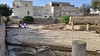
Punic town dating to 9th Century BCE, then Roman town and still inhabited. A tophet, or Punic Temple, was found here but much of the archeology is covered by the vibrant modern town.
You may be viewing yesterday's version of this page. To see the most up to date information please register for a free account.
")
Do not use the above information on other web sites or publications without permission of the contributor.
Nearby Images from Flickr


The above images may not be of the site on this page, but were taken nearby. They are loaded from Flickr so please click on them for image credits.
Click here to see more info for this site
Nearby sites
Click here to view sites on an interactive map of the areaKey: Red: member's photo, Blue: 3rd party photo, Yellow: other image, Green: no photo - please go there and take one, Grey: site destroyed
Download sites to:
KML (Google Earth)
GPX (GPS waypoints)
CSV (Garmin/Navman)
CSV (Excel)
To unlock full downloads you need to sign up as a Contributory Member. Otherwise downloads are limited to 50 sites.
Turn off the page maps and other distractions
Nearby sites listing. In the following links * = Image available
2.9km NNE 19° Sousse Museum* Museum
43.6km NNW 330° Enfidhia Museum* Museum
45.8km NNW 336° Castres Shgrania* Ancient Village or Settlement
56.3km S 173° Thysdrus* Ancient Village or Settlement
56.9km S 173° El Jem Museum* Museum
66.5km N 355° Pupput* Ancient Village or Settlement
71.7km N 7° Nabeul Museum Museum
71.9km N 7° Neapolis (Nabeul)* Ancient Village or Settlement
93.4km NW 316° Thuburbo Majus* Ancient Village or Settlement
119.2km S 174° Municipalité de Sfax Musee Museum
119.2km NNW 347° Carthage Tophet* Ancient Temple
119.6km NNW 347° Carthage Punic Port* Ancient Mine, Quarry or other Industry
120.1km NNW 347° Carthage Magon Quarter* Ancient Village or Settlement
120.4km NNW 347° Carthage Byrsa* Ancient Village or Settlement
120.5km NNW 348° Carthage Punic Tomb 3* Barrow Cemetery
120.5km NNW 348° Carthage Punic Tomb 2* Barrow Cemetery
120.5km NNW 348° Carthage Punic Tomb 1* Rock Cut Tomb
120.9km NNW 347° Carthage Temple of Saturn* Ancient Village or Settlement
120.9km NNW 339° Musee du Bardo* Museum
122.6km NNE 17° El Harouri Necropolis Rock Cut Tomb
123.5km NNE 21° Cloupia* Ancient Village or Settlement
123.6km NNE 21° Kelibia Fortress* Hillfort
127.9km S 178° Thaenae Ancient Village or Settlement
128.0km W 273° Mactaris* Ancient Village or Settlement
128.1km W 273° Maktar Museum* Museum
View more nearby sites and additional images


 We would like to know more about this location. Please feel free to add a brief description and any relevant information in your own language.
 Wir möchten mehr über diese Stätte erfahren. Bitte zögern Sie nicht, eine kurze Beschreibung und relevante Informationen in Deutsch hinzuzufügen.
 Nous aimerions en savoir encore un peu sur les lieux. S'il vous plaît n'hesitez pas à ajouter une courte description et tous les renseignements pertinents dans votre propre langue.
 Quisieramos informarnos un poco más de las lugares. No dude en añadir una breve descripción y otros datos relevantes en su propio idioma.