

<< Our Photo Pages >> Djupedalsborgen - Hillfort in Norway in Oppland
Submitted by kenntha88 on Sunday, 18 September 2022 Page Views: 343
Iron Age and Later PrehistorySite Name: DjupedalsborgenCountry: Norway
NOTE: This site is 2.163 km away from the location you searched for.
Fylke: Oppland Type: Hillfort
Nearest Town: Gjøvik Nearest Village: Kapp
Latitude: 60.711888N Longitude: 10.807098E
Condition:
| 5 | Perfect |
| 4 | Almost Perfect |
| 3 | Reasonable but with some damage |
| 2 | Ruined but still recognisable as an ancient site |
| 1 | Pretty much destroyed, possibly visible as crop marks |
| 0 | No data. |
| -1 | Completely destroyed |
| 5 | Superb |
| 4 | Good |
| 3 | Ordinary |
| 2 | Not Good |
| 1 | Awful |
| 0 | No data. |
| 5 | Can be driven to, probably with disabled access |
| 4 | Short walk on a footpath |
| 3 | Requiring a bit more of a walk |
| 2 | A long walk |
| 1 | In the middle of nowhere, a nightmare to find |
| 0 | No data. |
| 5 | co-ordinates taken by GPS or official recorded co-ordinates |
| 4 | co-ordinates scaled from a detailed map |
| 3 | co-ordinates scaled from a bad map |
| 2 | co-ordinates of the nearest village |
| 1 | co-ordinates of the nearest town |
| 0 | no data |
Internal Links:
External Links:
")
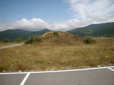
This hillfort is different from a several typical hillforts as it is not located on a hill or rocky outcrop but rather in a flat landscape with a river valley separating it from the nearby landscape. The river that was once larger has sloopes around 20 metres in height and would be a natural barrier. The almost dry river valley is called Djupedalen, after which the fort takes its name.
An almost dry river with steep slopes down to the river surrounds the fort on 3 sides, to the east, north and west. The only flat ground access to the fort is from the south and this flat area separates the fort from the nearby fields by a ditch and a high rampart made of earth and stone.
The ditch is around 2 metres deep and the wall or rampart is 2-5 metres in height and from 2 to 4 metres wide with the ditch on the outer side to the south. They seem to have been made mostly of earth dug out from the ditch rather than stone walls. The fort has two access points or openings in the wall, one to the east and one to the west. The walls are mostly overgrown with trees and smaller brush but are still easy to follow. The fort is dated to around 400-500AD but has not been closely researched.
You may be viewing yesterday's version of this page. To see the most up to date information please register for a free account.
")
")
")
")
")
")
")
Do not use the above information on other web sites or publications without permission of the contributor.
Click here to see more info for this site
Nearby sites
Click here to view sites on an interactive map of the areaKey: Red: member's photo, Blue: 3rd party photo, Yellow: other image, Green: no photo - please go there and take one, Grey: site destroyed
Download sites to:
KML (Google Earth)
GPX (GPS waypoints)
CSV (Garmin/Navman)
CSV (Excel)
To unlock full downloads you need to sign up as a Contributory Member. Otherwise downloads are limited to 50 sites.
Turn off the page maps and other distractions
Nearby sites listing. In the following links * = Image available
2.2km S 183° Lunden-Nordlivegen* Cairn
2.2km S 186° Nedre-La* Round Barrow(s)
2.4km SSW 198° Kongsengen* Round Barrow(s)
2.6km S 190° Slettavegen-Grimstad* Round Barrow(s)
2.8km S 187° Prinsehaugen/Kongehaugen* Round Barrow(s)
3.0km S 178° Nedre Stabo* Round Barrow(s)
3.3km SSE 167° Alstadsteinen runestone* Carving
3.5km SSE 161° Alfstadhaug-Totenvegen* Stone Circle
3.8km SSE 147° Hoff (Oppland)* Round Barrow(s)
4.1km S 187° Kolbuvegen-Hammerstad* Round Barrow(s)
4.5km SE 135° Gile (Rondehaugen)* Barrow Cemetery
4.6km SE 141° Storhaugen-Totenvegen* Round Barrow(s)
5.5km SE 135° Balkeenga* Round Barrow(s)
5.6km ESE 122° Hatbøl* Round Barrow(s)
6.4km SE 126° Hveem Standing Stone* Standing Stone (Menhir)
7.3km NNE 19° Sterud Østre* Barrow Cemetery
7.8km NNE 33° Fossum (Hedmark)* Carving
9.8km ENE 74° Eiksberget* Hillfort
10.1km S 188° Hol-Mellom* Round Barrow(s)
10.5km NNE 30° Ousdal Nordre* Barrow Cemetery
10.6km NNE 34° Duengerhøgda-Ousdal* Round Barrow(s)
10.7km SSW 192° Haugset Runestone* Carving
11.3km NNE 24° Trosteberget Hillfort* Hillfort
16.1km NE 43° Furuberget* Hillfort
16.6km NW 314° Mælum* Barrow Cemetery
View more nearby sites and additional images


 We would like to know more about this location. Please feel free to add a brief description and any relevant information in your own language.
 Wir möchten mehr über diese Stätte erfahren. Bitte zögern Sie nicht, eine kurze Beschreibung und relevante Informationen in Deutsch hinzuzufügen.
 Nous aimerions en savoir encore un peu sur les lieux. S'il vous plaît n'hesitez pas à ajouter une courte description et tous les renseignements pertinents dans votre propre langue.
 Quisieramos informarnos un poco más de las lugares. No dude en añadir una breve descripción y otros datos relevantes en su propio idioma.