<< Our Photo Pages >> Druid's Stone (Bungay) - Natural Stone / Erratic / Other Natural Feature in England in Suffolk
Submitted by hamstermoon on Wednesday, 12 October 2022 Page Views: 6599
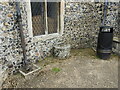
Natural PlacesSite Name: Druid's Stone (Bungay) Alternative Name: Devil's Stone, Giant's GraveCountry: England County: Suffolk Type: Natural Stone / Erratic / Other Natural Feature
Nearest Town: Bungay
Map Ref: TM3366689739
Latitude: 52.455583N Longitude: 1.437720E
Condition:
| 5 | Perfect |
| 4 | Almost Perfect |
| 3 | Reasonable but with some damage |
| 2 | Ruined but still recognisable as an ancient site |
| 1 | Pretty much destroyed, possibly visible as crop marks |
| 0 | No data. |
| -1 | Completely destroyed |
| 5 | Superb |
| 4 | Good |
| 3 | Ordinary |
| 2 | Not Good |
| 1 | Awful |
| 0 | No data. |
| 5 | Can be driven to, probably with disabled access |
| 4 | Short walk on a footpath |
| 3 | Requiring a bit more of a walk |
| 2 | A long walk |
| 1 | In the middle of nowhere, a nightmare to find |
| 0 | No data. |
| 5 | co-ordinates taken by GPS or official recorded co-ordinates |
| 4 | co-ordinates scaled from a detailed map |
| 3 | co-ordinates scaled from a bad map |
| 2 | co-ordinates of the nearest village |
| 1 | co-ordinates of the nearest town |
| 0 | no data |
Internal Links:
External Links:
 (PID:158606)")
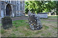
In the early 1920s it was referred to as a "fallen monolith", but was re-erected on its original site in about 1925.
One theory proposed it had been taken from the ruins of Bungay Castle for use as a headstone. The legend of the Druid's Stone says that after having danced about it, or knocked upon it, 12 times, young girls would place their ears against the stone to hear the answers to their questions or wishes. Another version states that children would dance around it 7 times on a certain day of the year, then wait for the Devil to appear.
Source: Hidden East Anglia:
Local writer W.A. Dutt wrote that "some consider it to be a Ley or Direction Stone..."
See also The Northern Antiquarian's page for Druid’s Stone, Bungay, Suffolk for local folklore.
Ref: Dutt, W.A., The Ancient Mark-Stones of East Anglia, Flood & Sons: Lowestoft 1926. (see below for links)
You may be viewing yesterday's version of this page. To see the most up to date information please register for a free account.
 (PID:158607)")
Do not use the above information on other web sites or publications without permission of the contributor.
Nearby Images from Geograph Britain and Ireland:
©2010(licence)
©2011(licence)
©2016(licence)
©2016(licence)
©2023(licence)
The above images may not be of the site on this page, they are loaded from Geograph.
Please Submit an Image of this site or go out and take one for us!
Click here to see more info for this site
Nearby sites
Key: Red: member's photo, Blue: 3rd party photo, Yellow: other image, Green: no photo - please go there and take one, Grey: site destroyed
Download sites to:
KML (Google Earth)
GPX (GPS waypoints)
CSV (Garmin/Navman)
CSV (Excel)
To unlock full downloads you need to sign up as a Contributory Member. Otherwise downloads are limited to 50 sites.
Turn off the page maps and other distractions
Nearby sites listing. In the following links * = Image available
1.7km NNE 28° Broome Heath Long Barrow Long Barrow (TM344913)
4.8km SW 227° Flixton Park Quarry Timber Circle (TM303863)
6.9km NE 48° Stockton Stone* Standing Stone (Menhir) (TM386946)
14.9km WNW 298° Tasburgh Fort* Hillfort (TM201960)
17.3km NW 325° Venta Icenorum* Ancient Village or Settlement (TG230034)
17.6km SE 143° Ladywell (Blythborough)* Holy Well or Sacred Spring (TM450762)
18.2km NE 55° Mill Hill Round Barrow(s) (TG480010)
18.2km NE 55° Bell Hill Round Barrow(s) (TG480010)
18.9km NNW 332° Arminghall Henge* Henge (TG240060)
19.2km SW 220° Kesgrave Bowl Barrow 2 Round Barrow(s) (TM220745)
20.0km NE 46° Burgh Castle Shore Fort Stone Fort or Dun (TG474044)
20.1km SE 141° Walberswick Burial Mounds* Round Barrow(s) (TM4718274820)
20.1km SW 234° St. Edmund's Cross Ancient Cross (TM1877)
20.4km NW 326° Eaton Heath Barrow Cemetery (TG21280605)
21.5km NNW 333° Norwich Castle Museum and Art Gallery* Museum (TG231085)
21.8km E 81° The Witches' Stones, Lowestoft Modern Stone Circle etc (TM5505294359)
23.2km ENE 56° Gull Stones (Great Yarmouth) Sculptured Stone (TG524035)
24.0km WSW 249° Diss Museum* Museum (TM1171179980)
25.8km WNW 300° St Thomas's Well (Wymondham)* Holy Well or Sacred Spring (TG10550146)
26.4km NW 319° St Walstan's Well* Holy Well or Sacred Spring (TG15350878)
26.6km NW 324° Roundwell* Holy Well or Sacred Spring (TG168104)
29.7km WSW 256° South Lopham Ox-Foot Stone* Natural Stone / Erratic / Other Natural Feature (TM05178098)
31.0km W 269° Vikings Mound* Artificial Mound (TM02678781)
31.8km NNW 335° Horsford Woods Barrow Cemetary* Barrow Cemetery (TG18571780)
32.1km W 274° Gallows Hill Tumulus Round Barrow(s) (TM01419019)
View more nearby sites and additional images


 We would like to know more about this location. Please feel free to add a brief description and any relevant information in your own language.
 Wir möchten mehr über diese Stätte erfahren. Bitte zögern Sie nicht, eine kurze Beschreibung und relevante Informationen in Deutsch hinzuzufügen.
 Nous aimerions en savoir encore un peu sur les lieux. S'il vous plaît n'hesitez pas à ajouter une courte description et tous les renseignements pertinents dans votre propre langue.
 Quisieramos informarnos un poco más de las lugares. No dude en añadir una breve descripción y otros datos relevantes en su propio idioma.